쿠어
쿠어(독일어: Chur, 이탈리아어: Coira 코이라[*], 프랑스어: Coire 쿠아르[*])는 스위스 그라우뷘덴주의 주도이자 가장 큰 도시이다. 라인강이 북쪽으로 향하는 그리송 강 계곡, 주의 북부에 있다. 라인강 오른쪽 강둑에 위치한 이 도시는 스위스에서 가장 오래된 도시로 유명하다.
| 쿠어 Chur | |||
|---|---|---|---|
 상류에서 서쪽으로 본 쿠어의 풍경 | |||
| |||
| 행정 | |||
| 국가 | |||
| 행정 구역 | 그라우뷘덴주 | ||
| 지리 | |||
| 면적 | 28.09㎢ | ||
| 해발 | 592m | ||
| 시간대 | CET (UTC+1) · 일광 절약 시간제: CEST (UTC+2) | ||
| 인문 | |||
| 인구 | 35,373명 (2018년) | ||
| 인구 밀도 | 1,300명/㎢ | ||
| 지역 부호 | |||
| 우편번호 | 7000 | ||
| 지역번호 | 3901 | ||
| 웹사이트 | (독일어) 공식 웹사이트 | ||


쿠어의 공식 언어는 독일어이지만, 주요 구어는 그리종 독일어로 알려진 알레만어의 현지 변종이다. 로만슈어와 이탈리아어는 한 주의 3개 국어를 사용하기 때문에 이 도시에서 상당히 많이 사용된다.
2020년 1월 1일 Maladers의 이전 지자체는 쿠어에 병합되었으며 2021년 1월 1일에는 할텐슈타인(Haldenstein)도 병합되었다.
역사 편집
동부 알프스에 있는 이 유적지에 정착했다는 고고학적 증거는 핀 문화(Pfyn, BC 3900-3500년)까지 거슬러 올라가며 쿠어를 스위스에서 가장 오래된 정착지 중 하나로 만든다. 청동기 시대와 철기 시대의 유물과 유물도 현재 도시 중심부의 동쪽 구역에서 발견되었다. 여기에는 기원전 1300-800년의 청동기 시대 우른필트(Urnfield)와 라우겐-멜라운(Laugen-Melaun) 정착지와 기원전 5세기에서 3세기의 철기 시대 정착지가 포함된다.
로마 제국은 BC 15년에 로마의 속주인 라이티아(Raetia)로 알려지게 된 지역을 정복했다. 3세기 후반 디오클레티아누스 황제 치하, 기존 정착지인 쿠리아 라에토룸(후에 쿠어)이 새로 설립된 라이티아 프리마 속주의 수도가 되었다.
4세기에 쿠어는 알프스 북쪽에 있는 최초의 기독교 주교구의 소재지가 되었다. 영국 왕으로 추정되는 성 루시우스(St. Lucius)에게 기초를 할당했다는 전설에도 불구하고, 최초의 알려진 주교는 서기 451년의 아시니오이다.
동고트족의 침략 이후에 테오도 리코폴리스로 이름이 바뀌었을 것이다. 6세기에는 프랑크인들에게 정복당했다. 이 도시는 대성당이 파괴되었을 때 925년 ~ 926년에 마자르인들과 사라센족(940년과 954년)에 의해 여러 차례 침략을 받았지만, 이후 여러 곳에서 오는 도로가 있는 위치 덕분에 번성했다. 주요 알파인 대중교통 경로가 함께 모여 라인강을 따라 계속된다. 이 경로는 이미 로마 시대에 사용되었지만, 신성 로마 제국의 오토 왕조 시대에 더 큰 중요성을 얻었다. 황제 오토 1세는 952년에 이 도시에 통행료를 징수할 수 있는 권리를 부여하고, 958년에 그의 봉신인 하트퍼트를 쿠어의 주교로 임명하여 주교관에게 수많은 특권을 부여했다. 1170년에 주교는 대주교가 되어 쿠어와 키아벤나 사이의 도로를 완전히 통제했다.
13세기에 이 도시는 약 1,300명의 주민이 있었고 벽으로 둘러싸여 있었다. 14세기에는 최소 6건의 화재로 성 루지 수도원과 성 니콜라이 수도원, 성 마틴 교회가 피해를 입었고, 두 번이나 마을 대부분이 파괴되었다. 1367년 쿠어 주교단과 합스부르크 가문의 세력이 커지는 것에 저항하기 위해 쿠어에서 신의 가문 동맹이 결성되었다. 쿠어는 연맹의 주요 도시이자 연맹 회의가 정기적으로 열리는 장소 중 하나였다. 1413년 쿠어의 부르크마이스터(시장)가 처음 언급되었으며, 1418년과 1422년에 주교의 거주지가 주민들의 공격을 받았으며, 그때 일련의 양보가 취소되었다.
1464년 4월 27일, 도시 대부분이 화재로 파괴되었고, 주교의 영지와 성 루지 수도원만 살아남았다. 근처의 합스부르크 티롤 후백국의 영향을 받아 주교의 권력이 약해지자 시민들은 황제 프리드리히 3세에게 사절단을 보냈다. 황제는 쿠어의 역사적 권리를 재확인하고 주교의 권력에서 도시를 해방시키는 광범위한 새로운 권리를 부여했다. 1465년 시민들은 쿠어의 길드에 모든 정부 권한을 부여하는 헌법을 작성했다. 모든 정부 직위는 길드원으로 제한되어 길드가 쿠어 생활의 모든 측면을 통제할 수 있었다. 길드 회원이 정치 권력에 이르는 유일한 통로였기 때문에, 지역 귀족과 귀족들은 빠르게 길드 회원이 되었고 종종 포도주 양조장 길드에 합류했다.
1471년에 신의 가문 동맹의 쿠어가 이끄는 연맹은 회색 동맹 및 십재판구 동맹과 연합하여 삼동맹을 형성했다. 1489년에 쿠어는 자체 재판소를 가질 권리를 얻었지만, 자유 제국 도시라는 칭호는 갖지 못했다. 1497-98년에 합스부르크의 확장과 쿠어의 주교가 오스트리아와 다투는 것을 우려하여 삼동맹은 구스위스 연방과 동맹을 맺었다. 1499년에 슈바벤 전쟁은 3개 동맹과 오스트리아 사이에 발발했고, 빠르게 연방을 포함하도록 확장되었다. 전쟁 기간 동안 쿠어의 군대는 보그트 하인리히 암만 주교의 지휘 하에 프레티가우 및 발저 근교에서 싸웠다. 쿠어의 군대는 1512년 발텔리나 침공과 1530~31년의 제2차 무쏘 전쟁에도 참전했다.
1523년 요하네스(도르프만) 코만더는 성 마르틴 교회의 교구 사제로 임명되어 종교 개혁의 새로운 신앙을 전파하기 시작했다. 종교개혁은 빠르게 확산되었고, 1524-25년까지 주교는 도시를 떠났다. 세인트 마틴과 세인트 레귤라 교회에서 개신교 예배가 열리고 있었다. 1524년과 1526년의 일란츠 조항은 삼 동맹의 각 거주자가 종교를 선택할 수 있도록 허용했으며, 동맹 영토에 있는 쿠어의 주교와 모든 수도원의 정치적, 세속적 권력을 급격히 감소시켰다. 1527년까지 주교의 영지를 제외한 모든 쿠어가 종교 개혁을 받아들였다. 1529년 1월 1일 아봇 테오도르 실레겔(Abbot Theodore Schlegel)은 공개적으로 참수되었다. 성 카를로 보로메오의 친구인 토마스 플란타 주교는 개신교를 진압하려고 시도했지만, 성공하지 못했다. 그는 1565년 5월 5일 독살된 것으로 추정되어 사망했다.
16세기 동안 독일어가 로만슈어보다 우세해지기 시작했다. 1479년에는 또 다른 화재로 약 300채의 가옥과 포장마차가 전소되었다. 거의 한 세기 후인 1574년 7월 23일, 화재로 174채의 집과 114개의 포장마차가 전소되었고, 이는 도시의 절반에 해당한다. 2년 후인 1576년 10월 21일에 또 다른 53채의 집이 불탔다. 1576년 화재가 발생한 지 2년 후, 가해자인 하우프트만 슈퇴르(Hauptmann Stör)가 처형당했다.
나폴레옹 전쟁 이후 삼동맹은 1803년 그라우뷘덴주가 되었다. 쿠어 시의 길드 구성은 1839년까지 지속되었으며, 1874년에는 부르커게마인데가 아인보너게마인데(Einwohnergemeinde)로 대체되었다. 1803년 그라우뷘덴이 주가 되자 쿠어가 수도로 선택되었다.
지리 편집
2004년 9월 조사 기준으로 쿠어는 54.33k㎡의 면적을 가지고 있다. 이 면적 중 약 17.6%가 농업용으로 사용되며 52.1%는 산림이다. 나머지 토지 중 26.5%는 정착지(건물 또는 도로)이고 3.9%는 불모지이다. 1979년/1985년부터 2004년 9월까지 지난 20년 동안 정착된 토지의 양은 86ha 증가하고 농경지는 87ha 감소했다.[1]
쿠어는 해발 594m 높이의 샨피그(Schanfigg) 계곡에서 발원하는 급류 플레수어강의 오른쪽 제방에 위치하고 있으며, 라인강과의 교차점에서 약 1.6km 높이로 거의 완전히 둘러싸여 있다. 푹 패인 깊은 계곡인 샤니그 계곡의 입구를 지키고 있는 북동쪽으로 미텐베르크(Mittenberg)와 남서쪽으로 피초겔(Pizoggel) 능선으로 드리워진 알프스 산맥으로 둘러싸여 있다.
도시 지역의 고도는 해발 600m에서 해발 1,800m까지 다양하며, 쿠어러 하우스베르크 브람브뤼시(구시가지에서 접근 가능)는 해발 2,174m에 위치해 있다.
쿠어의 샘물은 파수거(Passugger) 미네랄워터로 수출되어 판매되고 있다.
기후 편집
쿠어는 내륙에 위치함에도 불구하고, 해양성 기후를 가지고 있다. 여름은 따뜻하고 때때로 덥다. 일반적으로 낮에는 평균 약 25°C이며, 겨울 평균은 거의 영하로 내려가고 주간 온도는 약 5°C이다. 1981년과 2010년 사이에 쿠어의 연간 강우량은 평균 104.6일이었고 평균 강수량 은 849mm였다. 가장 습한 달은 8월로 이 기간 동안 쿠어의 평균 강수량은 112mm였다. 이 달 동안 평균 강수량은 11.2일이었다. 연중 가장 건조한 달은 2월로 6.6일 동안 평균 강수량이 47mm이다.[2]
| 쿠어 (1991–2020)의 기후 | |||||||||||||
|---|---|---|---|---|---|---|---|---|---|---|---|---|---|
| 월 | 1월 | 2월 | 3월 | 4월 | 5월 | 6월 | 7월 | 8월 | 9월 | 10월 | 11월 | 12월 | 연간 |
| 평균 일 최고 기온 °C (°F) | 5.2 (41.4) |
7.0 (44.6) |
11.9 (53.4) |
16.1 (61.0) |
20.3 (68.5) |
23.6 (74.5) |
25.3 (77.5) |
24.8 (76.6) |
20.3 (68.5) |
16.1 (61.0) |
10.2 (50.4) |
5.7 (42.3) |
15.5 (59.9) |
| 일 평균 기온 °C (°F) | 1.0 (33.8) |
2.1 (35.8) |
6.3 (43.3) |
10.2 (50.4) |
14.4 (57.9) |
17.7 (63.9) |
19.3 (66.7) |
18.9 (66.0) |
14.9 (58.8) |
10.8 (51.4) |
5.6 (42.1) |
1.9 (35.4) |
10.3 (50.5) |
| 평균 일 최저 기온 °C (°F) | −2.1 (28.2) |
−1.4 (29.5) |
1.9 (35.4) |
5.1 (41.2) |
9.3 (48.7) |
12.6 (54.7) |
14.3 (57.7) |
14.3 (57.7) |
10.6 (51.1) |
6.8 (44.2) |
2.4 (36.3) |
−1.0 (30.2) |
6.1 (43.0) |
| 평균 강수량 mm (인치) | 54 (2.1) |
40 (1.6) |
53 (2.1) |
50 (2.0) |
70 (2.8) |
93 (3.7) |
101 (4.0) |
119 (4.7) |
77 (3.0) |
67 (2.6) |
69 (2.7) |
58 (2.3) |
852 (33.5) |
| 평균 강설량 cm (인치) | 20 (7.9) |
18 (7.1) |
6 (2.4) |
1 (0.4) |
0 (0) |
0 (0) |
0 (0) |
0 (0) |
0 (0) |
1 (0.4) |
6 (2.4) |
17 (6.7) |
69 (27) |
| 평균 강수일수 (≥ 1.0 mm) | 7.8 | 6.5 | 7.1 | 7.1 | 9.7 | 11.4 | 11.3 | 11.5 | 8.6 | 7.7 | 8.3 | 8.0 | 105.0 |
| 평균 강설일수 (≥ 1.0 cm) | 4.1 | 3.2 | 1.9 | 0.3 | 0.0 | 0.0 | 0.0 | 0.0 | 0.0 | 0.1 | 1.2 | 3.3 | 14.1 |
| 평균 상대 습도 (%) | 74 | 69 | 64 | 61 | 64 | 67 | 68 | 71 | 74 | 74 | 75 | 75 | 70 |
| 평균 월간 일조시간 | 97 | 112 | 145 | 159 | 174 | 190 | 208 | 192 | 158 | 132 | 93 | 82 | 1,740 |
| 가능 일조율 | 49 | 53 | 54 | 53 | 49 | 52 | 57 | 59 | 58 | 54 | 46 | 45 | 53 |
| 출처: MeteoSwiss[2] | |||||||||||||
인구 통계 편집
쿠어의 인구(2020년 12월 31일 기준)는 36,336명이다. 2008년에는 인구의 17.8%가 외국인으로 구성되어 있었는데, 2014년에는 그 수치가 19.2%로 증가했다. 지난 4년(2010-2014) 동안 인구는 2.34%의 비율로 변경되었다. 2014년 시정촌의 출생률은 9.2명이었고 사망률은 인구 1000명당 10.0명이었다.[1] 2000년 기준 인구 대부분은 독일어(81.0%)를 사용하며 로만슈어가 두 번째로 많이 사용(5.4%)하고, 이탈리아어가 세 번째(5.1%)로 사용된다.[3]
2000년 기준으로 인구의 성별 분포는 남성 47.9%, 여성 52.1%였다.[4] 2000년을 기준으로 쿠어의 연령 분포는 다음과 같다. 인구의 9.4%인 3,087명이 0세에서 9세 사이이다. 10~14세는 1,602명(4.9%)이고 15~19세는 2,194명(6.7%)이다. 성인 인구 중 4,770명(인구의 14.5%)이 20~29세이다. 5,517명(16.7%)은 30~39세, 4,616명(14.0%)은 40~49세, 4,254명(12.9%)은 50~59세이다. 고령자 분포는 3,090명(인구의 9.4%(69세~60세))이다. 70~79세는 2,314명(7.0%), 80~89세는 1,307명(4.0%), 90~99세는 233명(0.7%), 100세 이상은 5명이다.[5]
2015년에는 독신 거주자 15,557명, 기혼 또는 동거 중인 13,722명, 미망인 1,948명, 이혼한 거주자 3,423명, 질문에 답변하지 않은 사람이 2명이었다.[6]
2014년에 쿠어에는 16,970개의 개인 가구가 있었고 평균 가구 규모는 2.00명이었다. 2000년 기준으로 시정촌 3,792채의 주거동 중 단독주택이 약 37.8%, 다가구주택이 39.7%를 차지하고 있다. 또한 건물의 약 20.5%가 1919년 이전에 지어졌고, 8.8%는 1991년에서 2000년 사이에 지어진 것이다.[7] 2013년 인구 1000명당 신축 주택 건설 비율은 7.71이다. 2015년 시정촌 공실률은 0.6%였다.[1]
과거 인구 통계 편집
역사적 인구는 다음 차트에 나와 있다.[8]

| 역사적 인구 데이터[8] | |||||||||||
|---|---|---|---|---|---|---|---|---|---|---|---|
| 년도 | 인구 | 스위스 | % 독일어 | % 이탈리아어 | % 로만쉬어 | % 개신교 | % 로마 가톨릭 | ||||
| 13세기 | 1,000-1,500 | ||||||||||
| 15세기 말 | ca. 1,500 | ||||||||||
| 1780 | 2,331 | ||||||||||
| 1860 | 6,990 | 6,373 | 60.8% | 39.1% | |||||||
| 1880a | 8,753 | 7,866 | 86.6% | 3.2% | 11.3% | 73.6% | 27.8% | ||||
| 1888 | 9,259 | 8,094 | 84.2% | 2.7% | 12.5% | 70.4% | 29.5% | ||||
| 1900 | 11,532 | 9,687 | 80.5% | 5.9% | 12.7% | 65.6% | 34.4% | ||||
| 1910 | 14,639 | 12,042 | 79.4% | 8.0% | 11.6% | 62.8% | 36.8% | ||||
| 1930 | 15,574 | 13,685 | 83.0% | 5.3% | 10.8% | 62.8% | 36.7% | ||||
| 1950 | 19,382 | 17,852 | 83.2% | 5.2% | 10.2% | 60.4% | 38.5% | ||||
| 1970 | 31,193 | 26,332 | 75.6% | 9.7% | 10.6% | 49.1% | 49.6% | ||||
| 1990 | 32,868 | 27,259 | 78.2% | 6.2% | 6.9% | 42.7% | 48.5% | ||||
| 2000 | 32,989 | 27,061 | 81.0% | 5.1% | 5.4% | 38.5% | 44.6% | ||||
| 2010 | 36,690 | 29,695 | 33.3% | 42.0% | |||||||
- ^a 언어는 제1언어뿐만 아니라 모든 언어를 세고 있기 때문에 100%가 넘는다.
종교 편집
2000년 인구 조사에 따르면 14,713명(44.6%)이 로마 가톨릭 신자이고, 12,199명(37.0%)이 스위스 개혁 교회에 속해 있다. 나머지 인구 중 크리스찬 가톨릭 교회 신자는 15명(전체 인구의 약 0.05%), 동방 정교회 신자는 589명(인구의 약 1.79%)이다. 그리고 다른 기독교 교회에 속한 532명의 개인(또는 인구의 약 1.61%)이 있다. 유대인은 13명(인구의 약 0.04%) 이고 무슬림은 917명(인구의 약 2.78%)이다. 다른 교회에 속해 있는 개인은 424명(인구의 약 1.29%)(인구 조사에 등재되지 않음), 1,998명(또는 인구의 약 6.06%)이 교회에 속하지 않고, 불가지론 또는 무신론자이며, 1,589명(인구의 약 4.82%)가 질문에 대답하지 않았다.[5]
교육 편집
쿠어에서 인구의 약 70.3%(25세에서 64세 사이)는 필수가 아닌 고등 교육 또는 추가 고등 교육(대학교 또는 응용학문대학)을 완료했다.[3] 이 마을에는 그라우뷘덴의 주립 학교가 있다.
경제 편집
2014년 기준으로 시정촌에 고용된 사람은 총 32,448명이다. 이 중 108명이 1차 경제 부문의 26개 기업에서 일했다. 1차 부문 직원의 대다수(68.5%)는 매우 작은 사업(직원 10명 미만)에서 일했다. 나머지는 총 34명의 직원이 있는 2개의 소규모 사업체에서 일했다. 2차 부문은 345개의 개별 사업에서 3,645명의 근로자를 고용했다. 2차 부문 직원의 소수(21.2%)는 매우 작은 사업체에서 일했다. 총 1,731명의 직원이 있는 75개의 중소기업과 1,141명의 직원이 있는 12개의 중소기업이 있었다. 마지막으로 3차산업 3,375개 기업에서 28,695개의 일자리를 제공했다. 2014년 기준 총 16,854명의 직원이 3,306개 중소기업(50인 미만)에서 근무했다. 9,093명의 직원을 둔 65개의 중소기업과 2,748명의 직원을 가진 4개의 대기업(평균 규모 687명)이 있었다.[9]
2014년에는 전체 인구의 7.7%가 사회 지원을 받았다.[1]
2015년 국내 호텔은 총 152,629건의 숙박을 했으며 그중 47.8%가 해외 방문객이었다.[10]
2015년 기준 2개의 영화관이 있었고 총 4개의 스크린과 736석의 좌석이 있었다.[11]
교통 편집


쿠어는 취리히에서 철도로 120km 떨어져 있으며, 이탈리아에서 출발하는 많은 고산 고개(루크마니에 고개, 스플뤼겐 고개 및 산베르나르디노 고개)와 엥가딘(알불라 고개, 율리어 고개)을 통과하는 경로의 만남의 지점이다. 활발한 무역(특히 발텔리나산 와인)의 중심지이지만, 몇 개의 지역 공장도 있다.[12]
도시의 주요 기차역인 쿠어역은 스위스 연방 철도 시스템이 래티셰 철도(RhB)와 연결되는 곳이다. SBB 노선이 대부분의 스위스에 서비스를 제공하는 반면, 대부분의 그라우뷘덴 내부 철도 교통은 RhB 노선이 운행한다. (아로자까지) RhB 노선 중 하나는 역에 도달하기 위해 쿠어와 잔드의 중심에 있는 거리를 가로질러 달리는 도로를 사용한다. (쿠어 슈타트반 참조)
쿠어에는 3개의 다른 기차역이 있다:
기차역 위에는 포스트버스 정류장도 있다.
쿠어는 A13 고속도로로 연결되어 있다.
관광 편집
쿠어에는 국가적으로 중요한 스위스 유산으로 등록된 많은 건물이나 기타 유적지가 있다. 쿠어에는 중세 도시인 구시가지와 선사 시대 정착지인 벨쉬도르피(Welschdörfi)와 로마 비쿠스가 있다. 4개의 아카이브 또는 라이브러리가 있다. 주교의 궁전(도서관 및 기록 보관소), 주립 도서관, 그라우뷘덴의 주립 기록 보관소와 쿠어의 도시 기록 보관소. 목록에는 4개의 박물관도 있다.
- Bündner Kunstmuseum (미술관)
- Bündner Naturmuseum (자연사 박물관)
- Dommuseum
- Haus Buol의 Rätisches 박물관
3개의 교회가 목록에 포함되어 있다.
- Assumption 대성당
- 성 루치의 가톨릭 교회
- 세인트 마틴의 개혁 교회
문화유산이기도 한 15개의 다른 건물이 있다. 여기에는 조이크하우스(Zeughaus) 3의 옛 무기고, 연방 제지 공장, 중앙 우체국, 새로운 시청, 레티쉬 철도의 본부와 여러 오래된 귀족 가옥이 포함된다. 2021년 할덴슈타인이 쿠어로 합병되면서 할덴슈타인 요새 유적과 할덴슈타인 성이 쿠어의 일부가 되었다.
갤러리 편집
-
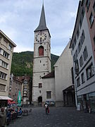
 포스트슈트라세, 구도심
 -
 그리소니안 예술 박물관 (Grisonian Art Museum).
 -
 성 마틴 교회
 -
 주립 법원
주립 법원 -
 the Assumption 대성당
 -
 알트슈타트의 거리


_41.jpg)
대성당 부지의 첫 번째 교회는 5세기 전반부에 세워졌다. 로마네스크 양식의 지하실은 아마도 텔로 주교(758-73)에 의해 지어졌을 것이다. 여기에는 알브레히트 뒤러와 한스 홀바인의 놀라운 그림이 포함되어 있다. 현재 건물은 1154년에서 1270년 사이에 지어졌다. 1272년에는 성모 승천에 헌정되었다. 중앙 축을 따라 있는 둥근 아치창은 그라우뷘덴에서 가장 큰 중세 창이다. 후기 고딕 양식의 높은 제단은 1492년 야콥 루스(Jakob Russ)에 의해 완성되었다.
성 루지 교회는 8세기에 지어진 것으로 추정되지만, 성 루지우스의 유물이 교회에서 제거된 821년에 첫 번째 기록이 나타난다. 중세 초기에 카롤루스 서기관 학교가 있던 곳이었을 것이다. 1149년에는 Premonstratensian 수도원의 교회가 되었다.
이 마을에는 스위스 예술가 HR 기거가 디자인한 기거 바, 구시가지, 미술관 및 자연사 박물관이 있다.
스포츠 편집
쿠어의 아이스하키팀인 EHC 쿠어는 스위스 아이스하키 리그 시스템의 3부 리그인 스위스 1. 리가에서 뛰고 있다. 그들은 6,500석의 할렌슈타디온에서 홈 경기를 한다.
미식축구팀 칼란다 브론코스 (구 란트콰르트 브론코스)는 2009년에 쿠어로 이적하여 링스트라세 경기장에서 홈 경기를 펼쳤다. 브론코스는 현재 내셔널 리가 A에서 뛰고 있으며 2010년 EFAF 컵 우승, 2012년 유로볼 우승을 비롯해 최다 스위스 볼 우승(8승) 기록을 가진 가장 성공적인 스위스 미식 축구팀이다. 2017년 현재 그들은 1위를 차지했다. 리그에서 7월 8일에 링슈트라세 스타디움에서 스위스 볼 XXXII를 개최하여 바젤 글래디 에이터즈를 42-6으로 꺾었다.
지역 축구팀은 스위스 축구 6부 리그에서 뛰고 있는 FC 쿠어 97이 있다. 그들은 링슈트라세에서 홈 게임을 한다.
자매 도시 편집
각주 편집
- ↑ 가 나 다 라 Swiss Federal Statistical Office - Regional portraits accessed 27 October 2016.
- ↑ 가 나 “Climate Normals Chur (Reference period 1991−2020)” (PDF) (독일어프랑스어이탈리아어). 연방 기상청. 2022년 1월 20일에 원본 문서 (PDF)에서 보존된 문서. 2022년 1월 20일에 확인함., 기상관측소는 해발 556 m지점에 있다.
- ↑ 가 나 Swiss Federal Statistical Office 보관됨 5 1월 2016 - 웨이백 머신 accessed 27-Oct-2009.
- ↑ Graubunden in Numbers 보관됨 24 9월 2009 - 웨이백 머신 (독일어) accessed 21 September 2009.
- ↑ 가 나 Graubunden Population Statistics 보관됨 27 8월 2009 - 웨이백 머신 (독일어) accessed 21 September 2009.
- ↑ Swiss Federal Statistical Office - Ständige und nichtständige Wohnbevölkerung nach institutionellen Gliederungen, Geschlecht, Zivilstand und Geburtsort (독일어) accessed 8 September 2016.
- ↑ Swiss Federal Statistical Office STAT-TAB - Thema 09 - Bau- und Wohnungswesen (독일어) accessed 5 May 2016.
- ↑ 가 나 Chur in 독일어, 프랑스어, 이태리어 in 온라인 Historical Dictionary of Switzerland.
- ↑ Federal Statistical Office -Arbeitsstätten und Beschäftigte nach Gemeinde, Wirtschaftssektor und Grössenklasse accessed 31 October 2016.
- ↑ Federal Statistical Office - Hotellerie: Ankünfte und Logiernächte der geöffneten Betriebe accessed 31 October 2016.
- ↑ Swiss Federal Statistical Office - Kinoinfrastruktur nach Gemeinde und Kinotyp 보관됨 26 9월 2016 - 웨이백 머신 (독일어) accessed 9 August 2016.
- ↑ Coolidge 1911.