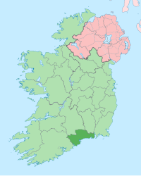
워터퍼드주
워터퍼드주(영어: County Waterford, 아일랜드어: Contae Phort Láirge 콘테 포르트 라르게)는 아일랜드의 주로 주도는 워터퍼드이며 면적은 1,857km2, 인구는 113,795명(2011년 기준)이다.

인구 편집
| 연도 | 인구 | ±% |
|---|---|---|
| 1600 | 14,456 | — |
| 1610 | 9,887 | −31.6% |
| 1653 | 13,136 | +32.9% |
| 1659 | 13,286 | +1.1% |
| 1821 | 76,103 | +472.8% |
| 1831 | 85,217 | +12.0% |
| 1841 | 196,187 | +130.2% |
| 1851 | 164,035 | −16.4% |
| 1861 | 134,252 | −18.2% |
| 1871 | 123,310 | −8.2% |
| 1881 | 112,768 | −8.5% |
| 1891 | 98,251 | −12.9% |
| 1901 | 87,187 | −11.3% |
| 1911 | 83,966 | −3.7% |
| 1926 | 78,562 | −6.4% |
| 1936 | 77,614 | −1.2% |
| 1946 | 76,108 | −1.9% |
| 1951 | 75,061 | −1.4% |
| 1956 | 74,031 | −1.4% |
| 1961 | 71,439 | −3.5% |
| 1966 | 73,080 | +2.3% |
| 1971 | 77,315 | +5.8% |
| 1979 | 87,278 | +12.9% |
| 1981 | 88,591 | +1.5% |
| 1986 | 91,151 | +2.9% |
| 1991 | 91,624 | +0.5% |
| 1996 | 94,680 | +3.3% |
| 2002 | 101,546 | +7.3% |
| 2006 | 107,961 | +6.3% |
| 2011 | 113,795 | +5.4% |
| 2016 | 116,176 | +2.1% |
| [1][2][3][4][5][6][7] | ||
각주 편집
- ↑ “Census 2016 Sapmap Area: County Waterford City And County”. Central Statistics Office (Ireland). 2018년 11월 18일에 원본 문서에서 보존된 문서. 2018년 11월 18일에 확인함.
- ↑ For 1653 and 1659 figures from Civil Survey Census of those years, Paper of Mr Hardinge to Royal Irish Academy 14 March 1865.
- ↑ “Census for post 1821 figures.”. Cso.ie. 2014년 8월 8일에 확인함.
- ↑ histpop.org 보관됨 7 5월 2016 - 웨이백 머신
- ↑ “NISRA – Northern Ireland Statistics and Research Agency (c) 2013”. Nisranew.nisra.gov.uk. 27 September 2010. 17 February 2012에 원본 문서에서 보존된 문서. 2014년 8월 8일에 확인함.
- ↑ Lee, JJ (1981). 〈On the accuracy of the Pre-famine Irish censuses〉. Goldstrom, J. M.; Clarkson, L. A. 《Irish Population, Economy, and Society: Essays in Honour of the Late K. H. Connell》. Oxford, England: Clarendon Press.
- ↑ Mokyr, Joel; O Grada, Cormac (November 1984). “New Developments in Irish Population History, 1700–1850”. 《The Economic History Review》 37 (4): 473–488. doi:10.1111/j.1468-0289.1984.tb00344.x. hdl:10197/1406. 2012년 12월 4일에 원본 문서에서 보존된 문서.
외부 링크 편집
| 이 글은 아일랜드에 관한 토막글입니다. 여러분의 지식으로 알차게 문서를 완성해 갑시다. |