파일:4U9525 flight path v1.svg

SVG 파일의 PNG 형식의 미리보기 크기: 440 × 366 픽셀. 다른 해상도: 289 × 240 픽셀 | 577 × 480 픽셀 | 923 × 768 픽셀 | 1,231 × 1,024 픽셀 | 2,462 × 2,048 픽셀
원본 파일 (SVG 파일, 실제 크기 440 × 366 픽셀, 파일 크기: 187 KB)
파일 설명
File:4U9525 flight path v1.svg has 2 translations.

카탈로니아어

영어


| 설명 |
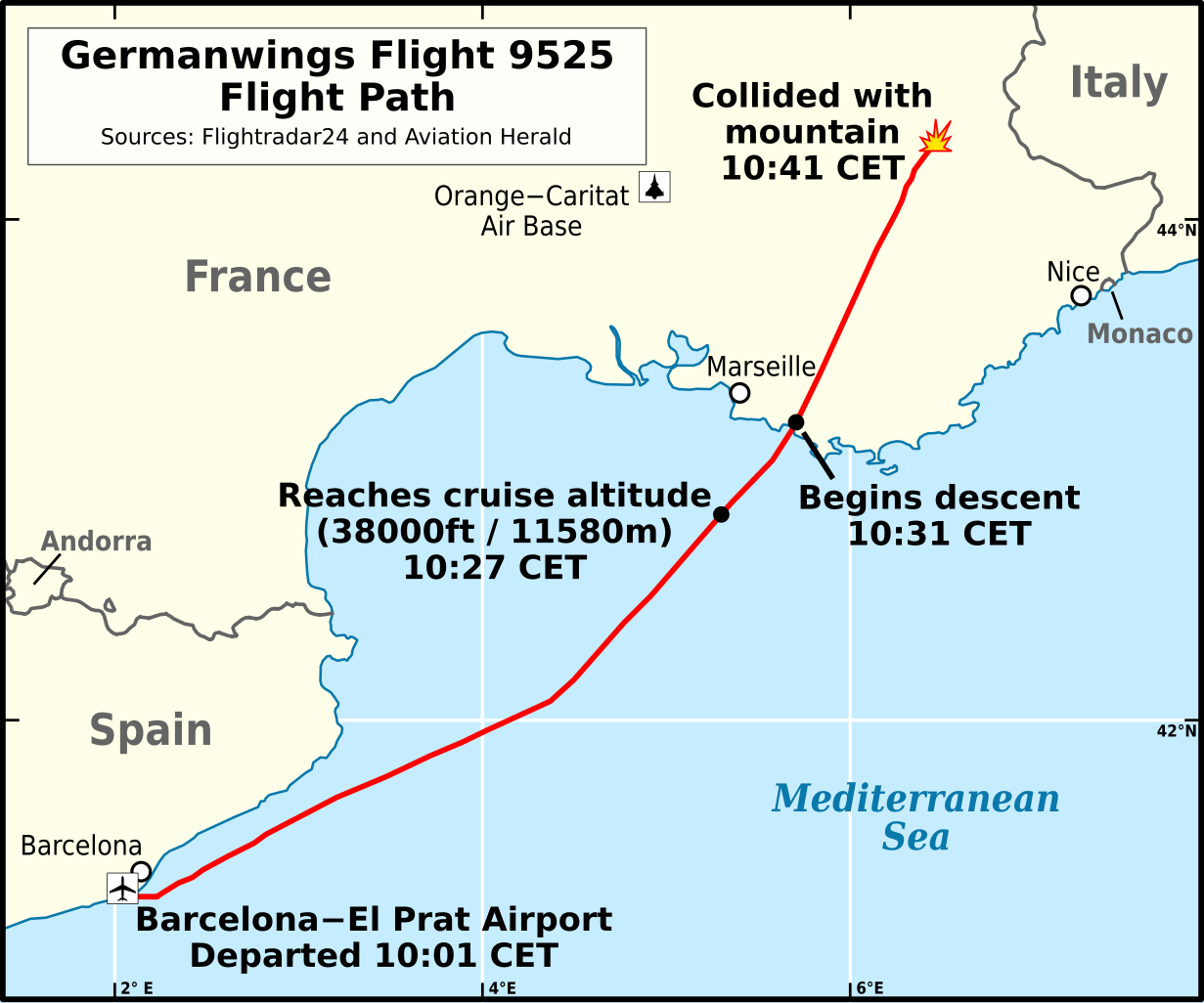
English: Flight path of Germanwings Flight 9525 (English).
Català: Trajectòria de vol Vol 9525 de Germanwings
Deutsch: Verlauf von Germanwings-Flug 9525 (Englisch).
Español: Trayectoria de Vuelo 9525 de Germanwings (Inglés).
Français : Trajectoire de vol Vol 9525 Germanwings (Anglais) |
|||
| 날짜 | ||||
| 출처 |
다음을 기초로 한 자작:
|
|||
| 저자 | Andrew Heneen | |||
| 저작권 (이 파일을 인용하기) |
나는 아래 작품의 저작권자로서, 이 저작물을 다음과 같은 라이선스로 배포합니다: 이 파일은 크리에이티브 커먼즈 저작자표시 4.0 국제 라이선스로 배포됩니다.
|
|||
| 다른 버전 | ||||
| SVG 발전 | 이 SVG 파일의 소스 코드를 194가지의 실수입니다. 이 SVG 지도는은 내장된 문자열을 사용하고 있으며 문서 편집기를 사용해서 쉽게 번역할 수 있습니다. |

파일 역사
날짜/시간 링크를 클릭하면 해당 시간의 파일을 볼 수 있습니다.
| 날짜/시간 | 섬네일 | 크기 | 사용자 | 설명 | |
|---|---|---|---|---|---|
| 현재 | 2023년 9월 20일 (수) 21:28 | | 440 × 366 (187 KB) | Lalpino | File uploaded using svgtranslate tool (https://svgtranslate.toolforge.org/). Added translation for ca. |
| 2023년 9월 20일 (수) 21:24 |  | 440 × 366 (187 KB) | Lalpino | File uploaded using svgtranslate tool (https://svgtranslate.toolforge.org/). Added translation for ca. | |
| 2020년 10월 18일 (일) 19:11 |  | 440 × 366 (173 KB) | Athozus | File uploaded using svgtranslate tool (https://svgtranslate.toolforge.org/). Added translation for fr. | |
| 2015년 3월 29일 (일) 06:34 |  | 440 × 366 (171 KB) | AHeneen | Remove rivers, move map boundaries (further north, south, & west), add air base, change font size of event labels (10-->12) | |
| 2015년 3월 25일 (수) 20:10 |  | 429 × 343 (166 KB) | AHeneen | decent-->descent | |
| 2015년 3월 25일 (수) 20:08 |  | 429 × 343 (166 KB) | AHeneen | User created page with UploadWizard |
이 파일을 사용하는 문서
다음 문서 1개가 이 파일을 사용하고 있습니다:
이 파일을 사용하고 있는 모든 위키의 문서 목록
다음 위키에서 이 파일을 사용하고 있습니다:
- af.wikipedia.org에서 이 파일을 사용하고 있는 문서 목록
- ca.wikipedia.org에서 이 파일을 사용하고 있는 문서 목록
- ca.wikinews.org에서 이 파일을 사용하고 있는 문서 목록
- cs.wikipedia.org에서 이 파일을 사용하고 있는 문서 목록
- en.wikipedia.org에서 이 파일을 사용하고 있는 문서 목록
- en.wikinews.org에서 이 파일을 사용하고 있는 문서 목록
- et.wikipedia.org에서 이 파일을 사용하고 있는 문서 목록
- fa.wikipedia.org에서 이 파일을 사용하고 있는 문서 목록
- fr.wikinews.org에서 이 파일을 사용하고 있는 문서 목록
- ga.wikipedia.org에서 이 파일을 사용하고 있는 문서 목록
- hu.wikipedia.org에서 이 파일을 사용하고 있는 문서 목록
- it.wikipedia.org에서 이 파일을 사용하고 있는 문서 목록
- mr.wikipedia.org에서 이 파일을 사용하고 있는 문서 목록
- no.wikipedia.org에서 이 파일을 사용하고 있는 문서 목록
- oc.wikipedia.org에서 이 파일을 사용하고 있는 문서 목록
- pl.wikipedia.org에서 이 파일을 사용하고 있는 문서 목록
- pt.wikipedia.org에서 이 파일을 사용하고 있는 문서 목록
- ru.wikipedia.org에서 이 파일을 사용하고 있는 문서 목록
- sr.wikinews.org에서 이 파일을 사용하고 있는 문서 목록
- th.wikipedia.org에서 이 파일을 사용하고 있는 문서 목록
- tr.wikipedia.org에서 이 파일을 사용하고 있는 문서 목록
- uk.wikipedia.org에서 이 파일을 사용하고 있는 문서 목록