파일:After Hama Massacre.jpg
미리 보기 크기: 589 × 600 픽셀 다른 해상도: 236 × 240 픽셀 | 607 × 618 픽셀
원본 파일 (607 × 618 픽셀, 파일 크기: 241 KB, MIME 종류: image/jpeg)
파일 설명
| 설명 |
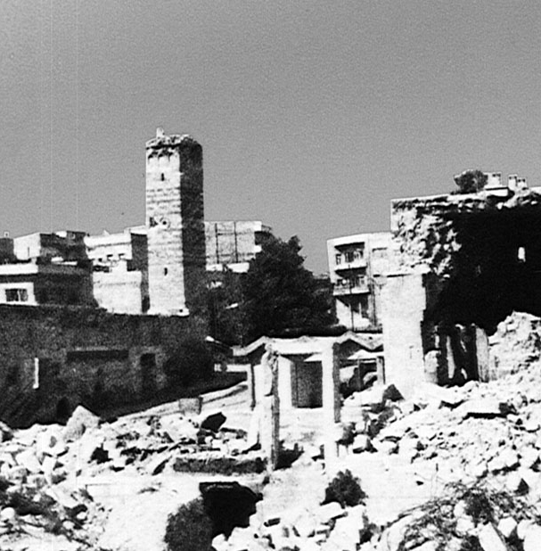
English: Image of Hama after Massacre in 1982, the compliment image of "Before Hama Massacre." Photograph shows the destroyed Al-Nuri Mosque, on the western bank of the Orontes River, next to the Hama Castle.
العربية: صورة لحماة بعد مجزرة عام 1982 |
| 출처 | http://lcweb2.loc.gov/cgi-bin/query/r?frd/cstdy:@field(DOCID+sy0027) "Library of Congress:A Country Study, Syria" |
| 저자 | Library of Congress |
| 저작권 (이 파일을 인용하기) |
US federal government in Public Domain |
| 다른 버전 |
 |
| 카메라 위치 | | 이 지역의 다른 사진을 보기: OpenStreetMap |
|---|
라이선스
이 파일은 미국 법전 제17편 제1장 제105조에 따른 미국 연방정부의 공무원 또는 피고용인이 공무상 작성한 저작물로, 미국에서 퍼블릭 도메인입니다.
주의: 본 라이선스는 미국 연방정부의 저작물에 관해서만 효력이 있습니다. 미국의 주, 군, 기타 지방자치단체가 만든 저작물에 대해서는 적용되지 않습니다. 또한 미국 우정청이 1978년부터 발행한 우표 디자인에도 적용되지 않습니다.
|
 | |
| 이 저작물은 모든 저작인접권을 포함한 저작권법하의 규제로부터 자유로운 것으로 확인되었습니다. | ||
기존 올리기 기록
Muhends 사용자가 CommonsHelper 도구를 사용하여 en.wikipedia에서 공용으로 옮겨왔습니다.
The original description page was here. All following user names refer to en.wikipedia.
- 2011-07-22 16:36 Guest2625 607×618 (91633 bytes) {{Information |Description = Image of Hama after Massacre in 1982, the compliment image of "Before Hama Massacre" |Source = http://lcweb2.loc.gov/cgi-bin/query/r?frd/cstdy:@field(DOCID+sy0027) "Library of Congress:A Country Study, Syria" |Da
파일 역사
날짜/시간 링크를 클릭하면 해당 시간의 파일을 볼 수 있습니다.
| 날짜/시간 | 섬네일 | 크기 | 사용자 | 설명 | |
|---|---|---|---|---|---|
| 현재 | 2017년 4월 4일 (화) 06:40 | | 607 × 618 (241 KB) | MrPenguin20 | Image was reversed. |
| 2012년 5월 4일 (금) 06:18 |  | 607 × 618 (89 KB) | File Upload Bot (Magnus Manske) | Transfered from en.wikipedia by User:muhends using CommonsHelper |
이 파일을 사용하는 문서
다음 문서 1개가 이 파일을 사용하고 있습니다:
이 파일을 사용하고 있는 모든 위키의 문서 목록
다음 위키에서 이 파일을 사용하고 있습니다:
- ar.wikipedia.org에서 이 파일을 사용하고 있는 문서 목록
- azb.wikipedia.org에서 이 파일을 사용하고 있는 문서 목록
- az.wikipedia.org에서 이 파일을 사용하고 있는 문서 목록
- da.wikipedia.org에서 이 파일을 사용하고 있는 문서 목록
- de.wikipedia.org에서 이 파일을 사용하고 있는 문서 목록
- en.wikipedia.org에서 이 파일을 사용하고 있는 문서 목록
- fa.wikipedia.org에서 이 파일을 사용하고 있는 문서 목록
- fi.wikipedia.org에서 이 파일을 사용하고 있는 문서 목록
- fr.wikipedia.org에서 이 파일을 사용하고 있는 문서 목록
- he.wikipedia.org에서 이 파일을 사용하고 있는 문서 목록
- hy.wikipedia.org에서 이 파일을 사용하고 있는 문서 목록
- it.wikipedia.org에서 이 파일을 사용하고 있는 문서 목록
- ja.wikipedia.org에서 이 파일을 사용하고 있는 문서 목록
- nn.wikipedia.org에서 이 파일을 사용하고 있는 문서 목록
- no.wikipedia.org에서 이 파일을 사용하고 있는 문서 목록
- pl.wikipedia.org에서 이 파일을 사용하고 있는 문서 목록
- pt.wikipedia.org에서 이 파일을 사용하고 있는 문서 목록
- ru.wikipedia.org에서 이 파일을 사용하고 있는 문서 목록
- sh.wikipedia.org에서 이 파일을 사용하고 있는 문서 목록
- sl.wikipedia.org에서 이 파일을 사용하고 있는 문서 목록
- tr.wikipedia.org에서 이 파일을 사용하고 있는 문서 목록
- uk.wikipedia.org에서 이 파일을 사용하고 있는 문서 목록
- uz.wikipedia.org에서 이 파일을 사용하고 있는 문서 목록
- war.wikipedia.org에서 이 파일을 사용하고 있는 문서 목록
- www.wikidata.org에서 이 파일을 사용하고 있는 문서 목록
- zh.wikipedia.org에서 이 파일을 사용하고 있는 문서 목록