파일:Antarctica 6400px from Blue Marble.jpg

미리 보기 크기: 600 × 600 픽셀 다른 해상도: 240 × 240 픽셀 | 480 × 480 픽셀 | 768 × 768 픽셀 | 1,024 × 1,024 픽셀 | 2,048 × 2,048 픽셀 | 6,400 × 6,400 픽셀
원본 파일 (6,400 × 6,400 픽셀, 파일 크기: 3.31 MB, MIME 종류: image/jpeg)
파일 설명
| 설명 |
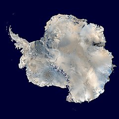
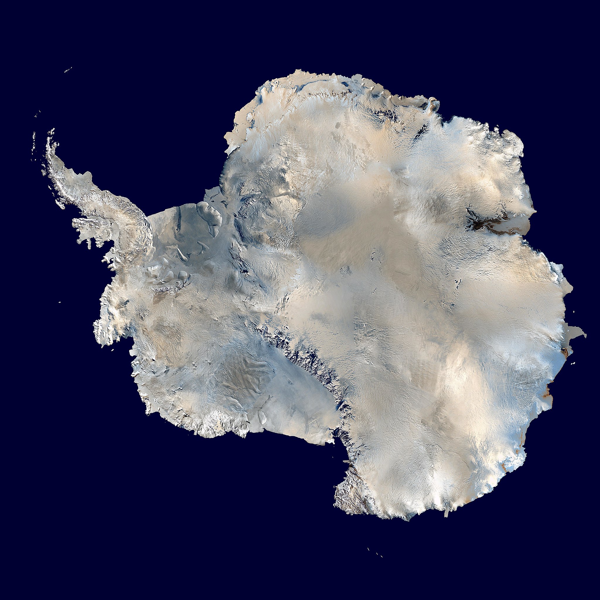
العربية: القارَّة القُطبيَّة الجنوبيَّة (أنتاركتيكا). صورة ساتليَّة تابعة لِوكالة ناسا، من ضمن بيانات الگُلَّة الزرقاء المُرسلة عبر الأقمار الاصطناعيَّة (من على بُعد كيلومترٍ واحد من العدسة الساتليَّة المُستخدمة). "تمَّ مزج بينات "MODIS" المُخصصة لِدراسة حالة الجليد القطبي مع تلك الخاصَّة بالإدارة القوميَّة لِدراسة المُحيطات والمُناخ—التي تمَّ الحصول عليها عبر الراديومتر الأكثر تطوُّرًا." تمَّ توليد الصورة باستخدام برنامج C مُخصص للتعامل مع صور وبيانات الگُلَّة الزرقاء، كما تمَّ الحصول على مُعادلات الإسقاط الشاقولي من موقع عالم الرِّياضيَّات.
مُلاحظة: تمَّ تعديل هذه الصورة يدويًّا في سبيل ملء بعض المناطق ذات العُنصورات (الپكسلات) السوداء، في الرُبعيَّة العُليا اليُمنى. يُعتقد بأنَّ تلك العُنصورات السوداء ظهرت نتيجة فُقدان بعض البيانات الخاصَّة بغطاء الأرض \ البحر المُستعملة في صناعة صورة الگُلَّة الزرقاء الأصليَّة. English: Antarctica. An orthographic projection of NASA's Blue Marble data set (1 km resolution global satellite composite). "MODIS observations of polar sea ice were combined with observations of Antarctica made by the National Oceanic and Atmospheric Administration’s AVHRR sensor—the Advanced Very High Resolution Radiometer." Image was generated using a custom C program for handling the Blue Marble files, with orthographic projection formulas from MathWorld.
Note: this image has been manually modified to fill in an area of black pixels in the ocean, in the upper right quadrant. The black pixels are presumed to be due to missing data in the land/sea mask used in making the original Blue Marble image. Español: El continente antártico. La imagen es una proyección ortogonal creada a partir del conjunto de datos satelitales Blue Marble de la NASA con una resolución de un kilómetro.
Français : Le continent Antarctique. L’image est construite en projection orthographique à partir des données satellites « Blue Marble » de la NASA, ayant une résolution d’un kilomètre. Les images de la banquise, prises par MODIS, ont été combinées avec celles du radiomètre avancé à très haute résolution de la National Oceanic and Atmospheric Administration pour former celle-ci. Elle a été générée en utilisant le logiciel MathWorld.
Note : cette image a été modifiée manuellement pour remplir une zone de pixels noir dans l’océan, dans le coin en haut à droite. Ces pixels manquants sont supposés être dus à des données manquantes dans le masque terre-mer utilisé pour construire l'image original de Blue Marble. Napulitano: Antartide, vista d’ ’o cielo.
Polski: Antarktyda. Odwzorowanie prostokątne opublikowanego w 2002 roku przez NASA zestawu danych Blue Marble.
مصرى: انتاركتيكا
فارسی: جنوبگان
Українська: Антарктида в ортографічній проекції з роздільною здатністю 1 км, на основі даних супутника MODIS. |
||
| 날짜 | |||
| 출처 | 다음을 사용한 자신의 작품: 2002 Blue Marble data @ http://visibleearth.nasa.gov/view_rec.php?id=2433 | ||
| 저자 | Dave Pape | ||
| 저작권 (이 파일을 인용하기) |
|
||
| 다른 버전 | 이 파일은 다음으로 파생됨: Antarctic Peninsula satellite image.jpgImage:Antarctica satellite globe.jpg |
수상
|

이 이미지는 2014년 10월 5일의 오늘의 이미지로 선정되었습니다. 이미지 설명은 다음과 같습니다. 다른 언어들:
Čeština: Antarktida v ortografické projekci ze souboru dat a fotografií NASA - NASA's Blue Marble data set. Français : Le continent Antarctique, image construite en projection orthographique à partir des données satellites « Blue Marble » de la NASA. Italiano: Proiezione ortogonale dell'Antartide della serie Blue Marble Next Generation della NASA, scattate con strumenti MODIS. Magyar: A NASA MODIS (Moderate-resolution Imaging Spectroradiometer) műszerével készült műholdkép az Antarktisz földrajzi zónában elhelyezkedő Antarktika kontinensről Polski: Antarktyda. Odwzorowanie prostokątne opublikowanego w 2002 roku przez NASA zestawu danych Blue Marble. Русский: Спутниковая фотография Антарктиды. |
| 주석 | 이 이미지에는 주석이 있습니다: 공용에서 주석을 보기 |
파일 역사
날짜/시간 링크를 클릭하면 해당 시간의 파일을 볼 수 있습니다.
| 날짜/시간 | 섬네일 | 크기 | 사용자 | 설명 | |
|---|---|---|---|---|---|
| 현재 | 2006년 10월 5일 (목) 23:21 | | 6,400 × 6,400 (3.31 MB) | Davepape | touched up part with missing data |
| 2006년 10월 5일 (목) 16:49 |  | 6,400 × 6,400 (3.31 MB) | Davepape | {{Information |Description=Antarctica. An orthographic projection of NASA's Blue Marble data set (1 km resolution global satellite composite). "MODIS observations of polar sea ice were combined with observations of Antarctica made by th |
이 파일을 사용하는 문서
다음 문서 4개가 이 파일을 사용하고 있습니다:
이 파일을 사용하고 있는 모든 위키의 문서 목록
다음 위키에서 이 파일을 사용하고 있습니다:
- ace.wikipedia.org에서 이 파일을 사용하고 있는 문서 목록
- ady.wikipedia.org에서 이 파일을 사용하고 있는 문서 목록
- af.wikipedia.org에서 이 파일을 사용하고 있는 문서 목록
- als.wikipedia.org에서 이 파일을 사용하고 있는 문서 목록
- ang.wikipedia.org에서 이 파일을 사용하고 있는 문서 목록
- anp.wikipedia.org에서 이 파일을 사용하고 있는 문서 목록
- ar.wikipedia.org에서 이 파일을 사용하고 있는 문서 목록
- القارة القطبية الجنوبية
- قائمة الصحاري حسب المساحة
- مستخدم:Almountasir
- بوابة:القارة القطبية الجنوبية/مشاريع ويكي
- مستخدم:لينيوس العربي
- مستخدم:عمرو/ميسرة
- مستخدم:Ahmad jbr
- مستخدم:عمرو/كاملة
- ويكيبيديا:ترشيحات الصور المختارة/صورة بالقمر الصناعي للقارة القطبية الجنوبية
- مستخدم:ديفيد/صور ساهمت في جعلها مختارة
- مستخدم:محمد نصار 1
- مستخدم:الحسن55
- ويكيبيديا:صور مختارة/الفضاء والكون/نظرة إلى الخلف
- ويكيبيديا:صورة اليوم المختارة/أكتوبر 2015
- قالب:صورة اليوم المختارة/2015-10-08
- صفيحة القارة القطبية الجنوبية الجليدية
- ويكيبيديا:صورة اليوم المختارة/يناير 2017
- قالب:صورة اليوم المختارة/2017-01-01
- مستخدم:صندوق مستخدم/مستخدم مشروع ويكي أنتاركتيكا
- ويكيبيديا:صورة اليوم المختارة/أكتوبر 2018
- قالب:صورة اليوم المختارة/2018-10-31
- ويكيبيديا:صورة اليوم المختارة/أبريل 2020
- قالب:صورة اليوم المختارة/2020-04-22
- ويكيبيديا:صورة اليوم المختارة/مارس 2023
- قالب:صورة اليوم المختارة/2023-03-03
- برنامج نيوزيلندا لأبحاث القطب الجنوبي
- arz.wikipedia.org에서 이 파일을 사용하고 있는 문서 목록
- ast.wikipedia.org에서 이 파일을 사용하고 있는 문서 목록
- as.wikipedia.org에서 이 파일을 사용하고 있는 문서 목록
이 파일의 더 많은 사용 내역을 봅니다.