파일:Bedford UK locator map.svg

SVG 파일의 PNG 형식의 미리보기 크기: 530 × 599 픽셀. 다른 해상도: 212 × 240 픽셀 | 425 × 480 픽셀 | 679 × 768 픽셀 | 906 × 1,024 픽셀 | 1,812 × 2,048 픽셀 | 1,120 × 1,266 픽셀
원본 파일 (SVG 파일, 실제 크기 1,120 × 1,266 픽셀, 파일 크기: 675 KB)
| 설명 |
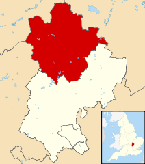
Map of Bedfordshire, UK with Bedford highlighted. Equirectangular map projection on WGS 84 datum, with N/S stretched 160% |
| 날짜 | |
| 출처 |
|
| 저자 | Nilfanion, created using Ordnance Survey data |
| 저작권 (이 파일을 인용하기) |
이 파일은 크리에이티브 커먼즈 저작자표시-동일조건변경허락 3.0 Unported 라이선스로 배포됩니다. 저작자표시: Contains Ordnance Survey data © Crown copyright and database right
|
파일 역사
날짜/시간 링크를 클릭하면 해당 시간의 파일을 볼 수 있습니다.
| 날짜/시간 | 섬네일 | 크기 | 사용자 | 설명 | |
|---|---|---|---|---|---|
| 현재 | 2011년 8월 4일 (목) 07:42 | | 1,120 × 1,266 (675 KB) | Nilfanion | {{Information |Description=Map of Bedfordshire, UK with Bedford highlighted. Equirectangular map projection on WGS 84 datum, with N/S stretched 160% |Source=Ordnance Survey [https://www.ord |
이 파일을 사용하는 문서
다음 문서 1개가 이 파일을 사용하고 있습니다:
이 파일을 사용하고 있는 모든 위키의 문서 목록
다음 위키에서 이 파일을 사용하고 있습니다:
- cy.wikipedia.org에서 이 파일을 사용하고 있는 문서 목록
- da.wikipedia.org에서 이 파일을 사용하고 있는 문서 목록
- en.wikipedia.org에서 이 파일을 사용하고 있는 문서 목록
- es.wikipedia.org에서 이 파일을 사용하고 있는 문서 목록
- fa.wikipedia.org에서 이 파일을 사용하고 있는 문서 목록
- fi.wikipedia.org에서 이 파일을 사용하고 있는 문서 목록
- frr.wikipedia.org에서 이 파일을 사용하고 있는 문서 목록
- fr.wikipedia.org에서 이 파일을 사용하고 있는 문서 목록
- Bedford (Royaume-Uni)
- Cardington (Bedfordshire)
- Kempston
- Wixams
- Bedford (district)
- Liste des paroisses civiles du Bedfordshire
- Carlton (Bedfordshire)
- Biddenham
- Modèle:Palette Bedford
- Oakley (Bedfordshire)
- Bletsoe
- Bolnhurst and Keysoe
- Colmworth
- Cople
- Wymington
- Staploe
- Stevington
- Stewartby
- Wootton (Bedfordshire)
- Willington (Bedfordshire)
- Wilden (Bedfordshire)
- Thurleigh
- Stagsden
- Sharnbrook
- Renhold
- Ravensden
- Podington
- Pertenhall
- Pavenham
- Odell (Bedfordshire)
- Milton Ernest
- Little Barford
- Little Staughton
- Harrold (Bedfordshire)
- Great Denham
- Great Barford
- Elstow
- Kempston Rural
- Knotting and Souldrop
- Dean and Shelton
- Wyboston, Chawston and Colesden
- Felmersham
- Chellington
이 파일의 더 많은 사용 내역을 봅니다.