파일:CircumnavigationByCapes.png
CircumnavigationByCapes.png (800 × 500 픽셀, 파일 크기: 286 KB, MIME 종류: image/png)
파일 설명
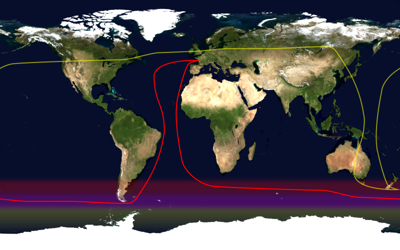
This image shows the route, in red, of a typical round-the-world yacht race via the great capes, by way of the roaring forties. Shown in yellow is the antipodean point of each point on the route; it can be seen that a boat following this route will not pass through any pair of antipodal points. Since doing so in the context of a race — particularly a non-stop race — would be impractical, yacht racing uses a different definition of a circumnavigation.
This image was constructed from a public domain Visible Earth product of the Earth Observatory office of the United States government space agency NASA. It is based on a cylindrical equi-distant projection.
라이선스
| 이 파일은 NASA에서 제작하였으므로 퍼블릭 도메인입니다. NASA의 저작권 정책에 따르면 NASA의 자료는 명시하지 않는 이상 저작권의 보호를 받지 않습니다. (Template:PD-USGov, 또는 NASA 저작권 정책 문서, JPL 그림 사용 정책을 참고하세요.) | ||
 |
주의사항:
|
파일 역사
날짜/시간 링크를 클릭하면 해당 시간의 파일을 볼 수 있습니다.
| 날짜/시간 | 섬네일 | 크기 | 사용자 | 설명 | |
|---|---|---|---|---|---|
| 현재 | 2006년 1월 24일 (화) 01:09 | | 800 × 500 (286 KB) | Johantheghost | This image shows the route, in red, of a typical round-the-world yacht race via the great capes, by way of the roaring forties. Shown in yellow is the [[Wikipedia:antipodes |
이 파일을 사용하는 문서
다음 문서 1개가 이 파일을 사용하고 있습니다:
이 파일을 사용하고 있는 모든 위키의 문서 목록
다음 위키에서 이 파일을 사용하고 있습니다:
- ast.wikipedia.org에서 이 파일을 사용하고 있는 문서 목록
- en.wikipedia.org에서 이 파일을 사용하고 있는 문서 목록
- es.wikipedia.org에서 이 파일을 사용하고 있는 문서 목록
- fr.wikipedia.org에서 이 파일을 사용하고 있는 문서 목록
- he.wikipedia.org에서 이 파일을 사용하고 있는 문서 목록
- ja.wikipedia.org에서 이 파일을 사용하고 있는 문서 목록
- la.wikipedia.org에서 이 파일을 사용하고 있는 문서 목록
- nl.wikipedia.org에서 이 파일을 사용하고 있는 문서 목록
- pl.wikipedia.org에서 이 파일을 사용하고 있는 문서 목록
- pt.wikipedia.org에서 이 파일을 사용하고 있는 문서 목록
- uk.wikipedia.org에서 이 파일을 사용하고 있는 문서 목록