파일:Civilizations map.png

원본 파일 (1,427 × 634 픽셀, 파일 크기: 41 KB, MIME 종류: image/png)
파일 설명
| 설명 |
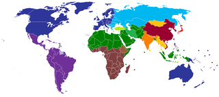
English: A map of civilizations, loosely based (see below) on Huntington's 1996 "Clash of Civilizations" (p. 26).
The NINE "civilizations" identified by Huntington are:
Other colors should indicate (light green, turquoise) the cultural fault lines where the clash of civilizations will occur. There are nine blocks shown in the original 1996 map. The additional colors, including the "fault line" countries in light green or turquoise are due to the judgement of the uploaders/creators of this map, not to Huntington. Other differences from the original map:
Español: Un mapa de civilizaciones, basado libremente (ver abajo) en el "Choque de civilizaciones" de Huntington en 1996 (p.26).
Las NUEVE "civilizaciones" identificadas por Huntington son:
Otros colores deben indicar (verde claro, turquesa) las fallas culturales donde ocurriera el choque de civilizaciones. Hay nueve bloques que se muestran en el mapa original de 1996. Los colores adicionales, incluidos los países de la "línea de falla" en color verde claro o turquesa, se deben a la opinión de los usuarios/creadores de este mapa, no a Huntington. Otras diferencias del mapa original:
Русский: Карта этнокультурного разделения цивилизаций, построенная по концепции Хантингтона.
עברית: תשע ה"ציביליזציות" שזוהו על ידי הנטינגטון הן:
Suomi: Tähän tulee suomenkielinen teksti. A map of civilizations, loosely based (see below) on Huntington's 1996 "Clash of Civilizations" (p. 26).
The NINE "civilizations" identified by Huntington are:
|
| 날짜 | |
| 출처 | 자작 (Usergreatpower) |
| 저자 | 영어 위키백과의 Usergreatpower |
| 다른 버전 | File:Clash of Civilizations map.png |
라이선스
| 이 작품은 저작자인 영어 위키백과의 Usergreatpower에 의해 퍼블릭 도메인으로 공개된 작품입니다. 이 공개 선언은 전 세계적으로 유효합니다. 만약 저작권의 포기가 법률적으로 가능하지 않은 경우, Usergreatpower은 이 작품을 법적으로 허용되는 한도 내에서 누구나 자유롭게 어떤 목적으로도 제한 없이 사용할 수 있도록 허용합니다. |
기존 올리기 기록
- 2008-11-20 23:07 Usergreatpower 1427×742× (55694 bytes) {{Information |Description=Clash of Civilisations map |Source=I created this work entirely by myself. |Date=20/11/2008 |Author=~~~ |other_versions= }}
| 주석 | 이 이미지에는 주석이 있습니다: 공용에서 주석을 보기 |
파일 역사
날짜/시간 링크를 클릭하면 해당 시간의 파일을 볼 수 있습니다.
| 날짜/시간 | 섬네일 | 크기 | 사용자 | 설명 | |
|---|---|---|---|---|---|
| 현재 | 2020년 5월 17일 (일) 04:49 | | 1,427 × 634 (41 KB) | Babelia | According to the book, Argentina is Latin American (despite the white majority and the southern European cultural influence) |
| 2019년 3월 27일 (수) 13:01 |  | 1,427 × 634 (37 KB) | Enterlousy | Since this is based LOOSELY on "Clash of Civilizations" I made some adjustments. As in the book, Mindanao is Islamic. However, Argentina should be Western, due to heavy Italian, German, and French influence due to immigration. | |
| 2013년 7월 25일 (목) 17:03 |  | 1,427 × 634 (38 KB) | Nikola Štuban | Croatia was in darker blue than the rest of the western world | |
| 2013년 7월 20일 (토) 04:39 |  | 1,427 × 634 (38 KB) | Quite vivid blur | Updated map to include South Sudan, corrections according to Samuel P. Huntington's The Clash of Civilizations. | |
| 2013년 5월 9일 (목) 19:27 |  | 1,427 × 634 (50 KB) | Valentinian | Rv one edit. Huntington very expressly assigns Turkey to its own category. | |
| 2013년 3월 8일 (금) 19:40 |  | 1,427 × 634 (50 KB) | Maphobbyist | Adjusted the green color for Turkey to the same hue used for Muslim countries. | |
| 2013년 2월 14일 (목) 09:36 |  | 1,427 × 634 (50 KB) | Yerevanci | since when is Turkey an Orthodox state? | |
| 2012년 11월 13일 (화) 04:58 |  | 1,427 × 742 (54 KB) | Wester | map is based on a book | |
| 2012년 9월 16일 (일) 20:09 |  | 1,427 × 742 (62 KB) | 23prootie~commonswiki | South Sudan is African. | |
| 2012년 8월 1일 (수) 07:02 |  | 1,427 × 742 (35 KB) | Carnby | Added South Sudan border since this map is based on present day political world map; probably it would have been better to choose a map with the borders of Huntington's times |
이 파일을 사용하는 문서
이 파일을 사용하는 문서가 없습니다.
이 파일을 사용하고 있는 모든 위키의 문서 목록
다음 위키에서 이 파일을 사용하고 있습니다:
- ar.wikipedia.org에서 이 파일을 사용하고 있는 문서 목록
- be-tarask.wikipedia.org에서 이 파일을 사용하고 있는 문서 목록
- be.wikipedia.org에서 이 파일을 사용하고 있는 문서 목록
- br.wikipedia.org에서 이 파일을 사용하고 있는 문서 목록
- ca.wikipedia.org에서 이 파일을 사용하고 있는 문서 목록
- ckb.wikipedia.org에서 이 파일을 사용하고 있는 문서 목록
- en.wikipedia.org에서 이 파일을 사용하고 있는 문서 목록
- Talk:Persecution of Christians in the post–Cold War era/Archive 1
- Talk:Roman Empire/Archive 7
- Wikipedia:Graphics Lab/Map workshop/Archive/Jun 2012
- User:The Stray Dog
- User talk:Robert McClenon/Archive 13
- User:The Stray Dog/COC
- User talk:Tryptofish/Archive 31
- User talk:KDTW Flyer/Archive 2016
- User:Oshwah/TalkPageArchives/2019-01
- User talk:CAPTAIN RAJU/Archive 68
- eo.wikipedia.org에서 이 파일을 사용하고 있는 문서 목록
- es.wikipedia.org에서 이 파일을 사용하고 있는 문서 목록
- fa.wikipedia.org에서 이 파일을 사용하고 있는 문서 목록
- fi.wikipedia.org에서 이 파일을 사용하고 있는 문서 목록
- fr.wikipedia.org에서 이 파일을 사용하고 있는 문서 목록
- gl.wikipedia.org에서 이 파일을 사용하고 있는 문서 목록
- he.wikipedia.org에서 이 파일을 사용하고 있는 문서 목록
- incubator.wikimedia.org에서 이 파일을 사용하고 있는 문서 목록
- ml.wikipedia.org에서 이 파일을 사용하고 있는 문서 목록
- nl.wikipedia.org에서 이 파일을 사용하고 있는 문서 목록
- pl.wikipedia.org에서 이 파일을 사용하고 있는 문서 목록
- pms.wikipedia.org에서 이 파일을 사용하고 있는 문서 목록
- pt.wikipedia.org에서 이 파일을 사용하고 있는 문서 목록
- ru.wikipedia.org에서 이 파일을 사용하고 있는 문서 목록
- tg.wikipedia.org에서 이 파일을 사용하고 있는 문서 목록
- uz.wikipedia.org에서 이 파일을 사용하고 있는 문서 목록