파일:DMZ in Goseong.jpg
최대 해상도입니다.
DMZ_in_Goseong.jpg (800 × 600 픽셀, 파일 크기: 96 KB, MIME 종류: image/jpeg)
파일 설명
| 설명 |
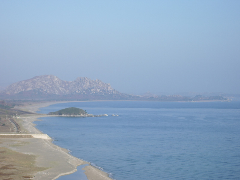
The turtle-shaped rock in the center left is the end of South Korean jurisdiction. The peaks in the distance, and the peninsula jutting to the right, are North Korea. The area in between is the Demilitarized Zone. On the peninsula there is a small village visible. I was told that it was an empty propaganda village, just like dozens of others North Korea maintains along the border. The beach looks lovely, and very inviting for a stroll. But it is safe to assume that landmines are everywhere down there, so even after permanent peace comes to the Korean peninsula, I can forget about a stroll down there. |
| 날짜 | |
| 출처 | DMZ |
| 저자 | Rachel from Los Angeles, California, USA |
| 카메라 위치 | | 이 지역의 다른 사진을 보기: OpenStreetMap |
|---|
라이선스
이 파일은 크리에이티브 커먼즈 저작자표시-동일조건변경허락 2.0 일반 라이선스로 배포됩니다.
- 이용자는 다음의 권리를 갖습니다:
- 공유 및 이용 – 저작물의 복제, 배포, 전시, 공연 및 공중송신
- 재창작 – 저작물의 개작, 수정, 2차적저작물 창작
- 다음과 같은 조건을 따라야 합니다:
- 저작자표시 – 적절한 저작자 표시를 제공하고, 라이센스에 대한 링크를 제공하고, 변경사항이 있는지를 표시해야 합니다. 당신은 합리적인 방식으로 표시할 수 있지만, 어떤 방식으로든 사용권 허가자가 당신 또는 당신의 사용을 지지하는 방식으로 표시할 수 없습니다.
- 동일조건변경허락 – 만약 당신이 이 저작물을 리믹스 또는 변형하거나 이 저작물을 기반으로 제작하는 경우, 당신은 당신의 기여물을 원저작물과 동일하거나 호환 가능한 라이선스에 따라 배포하여야 합니다.
| 이 이미지는 https://www.flickr.com/photos/56619626@N05/5270813526 에서 skinnylawyer에 의하여 플리커에 처음 게시되었습니다. 이것을 FlickreviewR 로봇이 검토하였고, cc-by-sa-2.0의 조건에 따른 라이선스임을 확인하였습니다. |
파일 역사
날짜/시간 링크를 클릭하면 해당 시간의 파일을 볼 수 있습니다.
| 날짜/시간 | 섬네일 | 크기 | 사용자 | 설명 | |
|---|---|---|---|---|---|
| 현재 | 2011년 5월 1일 (일) 18:43 | | 800 × 600 (96 KB) | TKostolany | {{Information |Description=The turtle-shaped rock in the center left is the end of South Korean jurisdiction. The peaks in the distance, and the peninsula jutting to the right, are North Korea. The area in between is the Demilitarized Zone. On the peni |
이 파일을 사용하는 문서
다음 문서 1개가 이 파일을 사용하고 있습니다:
이 파일을 사용하고 있는 모든 위키의 문서 목록
다음 위키에서 이 파일을 사용하고 있습니다:
- en.wikipedia.org에서 이 파일을 사용하고 있는 문서 목록
- fr.wikipedia.org에서 이 파일을 사용하고 있는 문서 목록
- ms.wikipedia.org에서 이 파일을 사용하고 있는 문서 목록
- sv.wikipedia.org에서 이 파일을 사용하고 있는 문서 목록