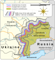
파일:Donbas (2015–2022).svg

SVG 파일의 PNG 형식의 미리보기 크기: 800 × 528 픽셀. 다른 해상도: 320 × 211 픽셀 | 640 × 422 픽셀 | 1,024 × 676 픽셀 | 1,280 × 845 픽셀 | 2,560 × 1,689 픽셀 | 1,523 × 1,005 픽셀
원본 파일 (SVG 파일, 실제 크기 1,523 × 1,005 픽셀, 파일 크기: 2.08 MB)
파일 역사
날짜/시간 링크를 클릭하면 해당 시간의 파일을 볼 수 있습니다.
| 날짜/시간 | 섬네일 | 크기 | 사용자 | 설명 | |
|---|---|---|---|---|---|
| 현재 | 2023년 9월 25일 (월) 05:31 |  | 1,523 × 1,005 (2.08 MB) | Mzajac | Updated English spelling for w:en:Berdiansk |
| 2022년 9월 14일 (수) 05:57 |  | 1,523 × 1,005 (2.08 MB) | Batouki | File uploaded using svgtranslate tool (https://svgtranslate.toolforge.org/). Added translation for en. | |
| 2022년 9월 11일 (일) 07:14 |  | 1,523 × 1,005 (2.07 MB) | Batouki | File uploaded using svgtranslate tool (https://svgtranslate.toolforge.org/). Added translation for fr. | |
| 2022년 9월 10일 (토) 03:30 |  | 1,523 × 1,005 (2.07 MB) | Batouki | File uploaded using svgtranslate tool (https://svgtranslate.toolforge.org/). Added translation for fr. | |
| 2022년 3월 11일 (금) 01:14 |  | 1,523 × 1,005 (2.03 MB) | Goran tek-en | minor stuff | |
| 2022년 3월 10일 (목) 19:54 |  | 1,518 × 1,000 (2.03 MB) | Goran tek-en | Donbas text edited requested by RGloucester | |
| 2022년 3월 10일 (목) 02:31 |  | 1,518 × 1,000 (2.03 MB) | Goran tek-en | {{Information |description ={{en|Map of the Donbas region of Ukraine, showing Russian separatist-controlled territory from the signing of the Minsk II agreement in 2015 to the outbreak of 2022 Russian invasion of Ukraine}} {{Institution |wikidata=Q16335075}} {{Institution |wikidata=Q605714}} {{Institution |wikidata=Q212}} {{Institution |wikidata=Q159}} |date =2022-03-09 |source ={{Own}} <br> Derived from; *[https://www.openstreetmap.org/#map=7/49.432/37.595 OSM] In... |
이 파일을 사용하는 문서
다음 문서 1개가 이 파일을 사용하고 있습니다:
이 파일을 사용하고 있는 모든 위키의 문서 목록
다음 위키에서 이 파일을 사용하고 있습니다:
- azb.wikipedia.org에서 이 파일을 사용하고 있는 문서 목록
- be.wikipedia.org에서 이 파일을 사용하고 있는 문서 목록
- bs.wikipedia.org에서 이 파일을 사용하고 있는 문서 목록
- de.wikipedia.org에서 이 파일을 사용하고 있는 문서 목록
- en.wikipedia.org에서 이 파일을 사용하고 있는 문서 목록
- en.wikinews.org에서 이 파일을 사용하고 있는 문서 목록
- fr.wikipedia.org에서 이 파일을 사용하고 있는 문서 목록
- he.wikipedia.org에서 이 파일을 사용하고 있는 문서 목록
- hr.wikipedia.org에서 이 파일을 사용하고 있는 문서 목록
- nl.wikipedia.org에서 이 파일을 사용하고 있는 문서 목록
- sl.wikipedia.org에서 이 파일을 사용하고 있는 문서 목록
- tr.wikipedia.org에서 이 파일을 사용하고 있는 문서 목록
- uz.wikipedia.org에서 이 파일을 사용하고 있는 문서 목록


