파일:Duchy of Prussia.svg

SVG 파일의 PNG 형식의 미리보기 크기: 610 × 588 픽셀. 다른 해상도: 249 × 240 픽셀 | 498 × 480 픽셀 | 797 × 768 픽셀 | 1,062 × 1,024 픽셀 | 2,125 × 2,048 픽셀
원본 파일 (SVG 파일, 실제 크기 610 × 588 픽셀, 파일 크기: 55 KB)
파일 설명
| 설명 |
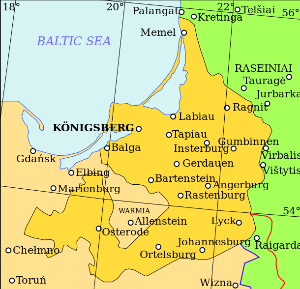
English: Map showing the Duchy of Prussia, at an indeterminable date. Place names inside the Duchy are given in German, as are Elbing and Marienburg. Other names are modern.
Territory of the Duchy of Prussia Territory of the Kingdom of Poland before the Union of Lublin Territory of the Grand Duchy of Lithuania before the Union of Lublin Polish-Lithuanian border before the Union of Lublin Polish-Lithuanian border after the Union of Lublin |
| 날짜 | |
| 출처 | 다음을 기초로 한 자작: (리투아니아어) (2001년) Lietuvos istorijos atlasas, 빌뉴스: Vaga, pp. 16—17 |
| 저자 | Grandiose |
| 다른 버전 |
|
| SVG 발전 |

| File | Type | Details |
|---|---|---|
| File:Polish-Lithuania map (1450-1600).svg | Large SVG | Map showing conflicts and territorial changes on the Polish-Lithuanian—Russian border, 1450–1600 |
| File:Duchy of Prussia.svg | Small SVG | Map of the Duchy of Prussia |
| File:Livonian war map (1558-1560).svg | Small SVG | Map showing campaigns in Livonia, 1558–1560. |
| File:Map of Poland and Lithuania after the Union of Lublin (1569).svg | Large SVG | Map of the w:Polish-Lithuanian Commonwealth after the Union of Lublin in 1569. |
| File:Livonian war map (1570-1577).svg | Small SVG | Map showing areas of Russian and Polish-Lithuanian forces, 1570–1577. |
| File:Campaigns of Stefan Batory.svg | Small SVG | Map of the campaign of Stefan Batory in Livonia (1575–1580). |
| File:Map of Poland and Lithuania in 1600.svg | Small SVG | Map of Livonia in 1600 |
| See also: User:Halibutt/maps, by Halibutt (토론 · 기여). | ||
.svg)
.svg)
.svg)
.svg)
라이선스
나는 아래 작품의 저작권자로서, 이 저작물을 다음과 같은 라이선스로 배포합니다:
이 파일은 크리에이티브 커먼즈 저작자표시-동일조건변경허락 3.0 Unported 라이선스로 배포됩니다.
- 이용자는 다음의 권리를 갖습니다:
- 공유 및 이용 – 저작물의 복제, 배포, 전시, 공연 및 공중송신
- 재창작 – 저작물의 개작, 수정, 2차적저작물 창작
- 다음과 같은 조건을 따라야 합니다:
- 저작자표시 – 적절한 저작자 표시를 제공하고, 라이센스에 대한 링크를 제공하고, 변경사항이 있는지를 표시해야 합니다. 당신은 합리적인 방식으로 표시할 수 있지만, 어떤 방식으로든 사용권 허가자가 당신 또는 당신의 사용을 지지하는 방식으로 표시할 수 없습니다.
- 동일조건변경허락 – 만약 당신이 이 저작물을 리믹스 또는 변형하거나 이 저작물을 기반으로 제작하는 경우, 당신은 당신의 기여물을 원저작물과 동일하거나 호환 가능한 라이선스에 따라 배포하여야 합니다.
파일 역사
날짜/시간 링크를 클릭하면 해당 시간의 파일을 볼 수 있습니다.
| 날짜/시간 | 섬네일 | 크기 | 사용자 | 설명 | |
|---|---|---|---|---|---|
| 현재 | 2011년 4월 20일 (수) 19:07 | | 610 × 588 (55 KB) | Grandiose | Correct spelling |
| 2011년 4월 19일 (화) 21:44 |  | 610 × 588 (54 KB) | Grandiose | Lines on longitude and latitude; other important fixes. | |
| 2011년 4월 19일 (화) 21:36 |  | 610 × 588 (1.1 MB) | Grandiose | Fix text locations | |
| 2011년 4월 19일 (화) 21:33 |  | 610 × 588 (1.1 MB) | Grandiose |
이 파일을 사용하는 문서
다음 문서 1개가 이 파일을 사용하고 있습니다:
이 파일을 사용하고 있는 모든 위키의 문서 목록
다음 위키에서 이 파일을 사용하고 있습니다:
- ar.wikipedia.org에서 이 파일을 사용하고 있는 문서 목록
- ast.wikipedia.org에서 이 파일을 사용하고 있는 문서 목록
- br.wikipedia.org에서 이 파일을 사용하고 있는 문서 목록
- ca.wikipedia.org에서 이 파일을 사용하고 있는 문서 목록
- cs.wikipedia.org에서 이 파일을 사용하고 있는 문서 목록
- de.wikipedia.org에서 이 파일을 사용하고 있는 문서 목록
- el.wikipedia.org에서 이 파일을 사용하고 있는 문서 목록
- en.wikipedia.org에서 이 파일을 사용하고 있는 문서 목록
- eu.wikipedia.org에서 이 파일을 사용하고 있는 문서 목록
- fa.wikipedia.org에서 이 파일을 사용하고 있는 문서 목록
- fi.wikipedia.org에서 이 파일을 사용하고 있는 문서 목록
- gl.wikipedia.org에서 이 파일을 사용하고 있는 문서 목록
- he.wikipedia.org에서 이 파일을 사용하고 있는 문서 목록
- hr.wikipedia.org에서 이 파일을 사용하고 있는 문서 목록
- hu.wikipedia.org에서 이 파일을 사용하고 있는 문서 목록
- is.wikipedia.org에서 이 파일을 사용하고 있는 문서 목록
- it.wikipedia.org에서 이 파일을 사용하고 있는 문서 목록
- ja.wikipedia.org에서 이 파일을 사용하고 있는 문서 목록
- lt.wikipedia.org에서 이 파일을 사용하고 있는 문서 목록
- mk.wikipedia.org에서 이 파일을 사용하고 있는 문서 목록
- rue.wikipedia.org에서 이 파일을 사용하고 있는 문서 목록
- ru.wikipedia.org에서 이 파일을 사용하고 있는 문서 목록
- sc.wikipedia.org에서 이 파일을 사용하고 있는 문서 목록
- sh.wikipedia.org에서 이 파일을 사용하고 있는 문서 목록
- sv.wikipedia.org에서 이 파일을 사용하고 있는 문서 목록
- th.wikipedia.org에서 이 파일을 사용하고 있는 문서 목록
- tr.wikipedia.org에서 이 파일을 사용하고 있는 문서 목록
- uk.wikipedia.org에서 이 파일을 사용하고 있는 문서 목록
- vi.wikipedia.org에서 이 파일을 사용하고 있는 문서 목록
- www.wikidata.org에서 이 파일을 사용하고 있는 문서 목록
- zh.wikipedia.org에서 이 파일을 사용하고 있는 문서 목록