파일:First 360 color panorama from the Curosity rover.jpg

미리 보기 크기: 798 × 196 픽셀 다른 해상도: 320 × 79 픽셀 | 640 × 157 픽셀 | 1,024 × 252 픽셀 | 1,280 × 314 픽셀 | 2,560 × 629 픽셀 | 14,494 × 3,560 픽셀
원본 파일 (14,494 × 3,560 픽셀, 파일 크기: 6.18 MB, MIME 종류: image/jpeg)
파일 설명
| 설명 |
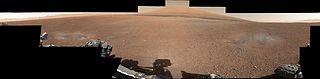
English: This color panorama shows a 360-degree view of the landing site of NASA's Curiosity rover, including the highest part of Mount Sharp visible to the rover. That part of Mount Sharp is approximately 12 miles (20 kilometers) away from the rover.
The images were obtained by the rover's 34-millimeter Mast Camera. The mosaic, which stretches about 29,000 pixels across by 7,000 pixels high, includes 130 images taken on Aug. 8 and an additional 10 images taken on Aug. 18. These images were shot before the camera was fully characterized. Scientists enhanced the color in one version to show the Martian scene as it would appear under the lighting conditions we have on Earth, which helps in analyzing the terrain. A raw version is also available. |
| 날짜 | |
| 출처 | http://photojournal.jpl.nasa.gov/catalog/PIA16029 |
| 저자 | NASA/JPL-Caltech/MSSS |
| 다른 버전 | File:Gale Crater landing site-2012.jpg (cropped) |
| 360° | 360° 파노라마 뷰어로 보기
|
|---|
라이선스
| 이 파일은 NASA에서 제작하였으므로 퍼블릭 도메인입니다. NASA의 저작권 정책에 따르면 NASA의 자료는 명시하지 않는 이상 저작권의 보호를 받지 않습니다. (Template:PD-USGov, 또는 NASA 저작권 정책 문서, JPL 그림 사용 정책을 참고하세요.) | ||
 |
주의사항:
|
This image or video was catalogued by Jet Propulsion Laboratory of the United States National Aeronautics and Space Administration (NASA) under Photo ID: PIA16101. This tag does not indicate the copyright status of the attached work. A normal copyright tag is still required. See Commons:Licensing. Other languages:
|
파일 역사
날짜/시간 링크를 클릭하면 해당 시간의 파일을 볼 수 있습니다.
| 날짜/시간 | 섬네일 | 크기 | 사용자 | 설명 | |
|---|---|---|---|---|---|
| 현재 | 2012년 8월 28일 (화) 11:14 | 14,494 × 3,560 (6.18 MB) | Rehman | replacing low-res PIA16029, with high-res PIA16101 | |
| 2012년 8월 10일 (금) 03:04 | 3,653 × 755 (265 KB) | Rehman |
이 파일을 사용하는 문서
다음 문서 1개가 이 파일을 사용하고 있습니다:
이 파일을 사용하고 있는 모든 위키의 문서 목록
다음 위키에서 이 파일을 사용하고 있습니다:
- bn.wikipedia.org에서 이 파일을 사용하고 있는 문서 목록
- ca.wikipedia.org에서 이 파일을 사용하고 있는 문서 목록
- cs.wikipedia.org에서 이 파일을 사용하고 있는 문서 목록
- de.wikipedia.org에서 이 파일을 사용하고 있는 문서 목록
- en.wikipedia.org에서 이 파일을 사용하고 있는 문서 목록
- es.wikipedia.org에서 이 파일을 사용하고 있는 문서 목록
- fa.wikipedia.org에서 이 파일을 사용하고 있는 문서 목록
- fr.wikipedia.org에서 이 파일을 사용하고 있는 문서 목록
- hr.wikipedia.org에서 이 파일을 사용하고 있는 문서 목록
- kk.wikipedia.org에서 이 파일을 사용하고 있는 문서 목록
- pl.wikipedia.org에서 이 파일을 사용하고 있는 문서 목록
- ro.wikipedia.org에서 이 파일을 사용하고 있는 문서 목록
- ru.wikipedia.org에서 이 파일을 사용하고 있는 문서 목록
- sr.wikipedia.org에서 이 파일을 사용하고 있는 문서 목록
- sr.wikinews.org에서 이 파일을 사용하고 있는 문서 목록
- test.wikipedia.org에서 이 파일을 사용하고 있는 문서 목록
- uk.wikipedia.org에서 이 파일을 사용하고 있는 문서 목록
- zh.wikipedia.org에서 이 파일을 사용하고 있는 문서 목록