파일:Great Schism 1054 with former borders.png

미리 보기 크기: 560 × 599 픽셀 다른 해상도: 224 × 240 픽셀 | 448 × 480 픽셀 | 717 × 768 픽셀 | 957 × 1,024 픽셀 | 2,000 × 2,141 픽셀
원본 파일 (2,000 × 2,141 픽셀, 파일 크기: 420 KB, MIME 종류: image/png)

|
이 그림 파일은 벡터 SVG 형식으로 다시 만들어야 합니다. SVG의 장점에 대해서는 여기(영어)를 참고해 주십시오. 만약 이 그림의 SVG 버전이 이미 존재한다면 이 틀을 {{vector version available|새 파일 이름.svg}}으로 대체해 주십시오.
|
파일 설명
| 설명 |
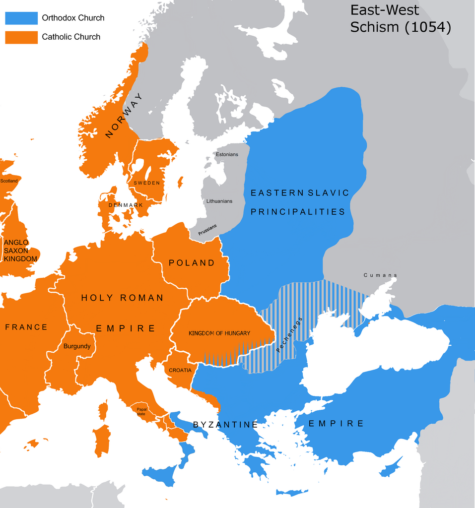
English: The map of the eastern/western allegiances in 1054 with the former country borders.
Español: El mapa de las creencias en el este/oeste en 1054 con las fronteras del país anterior. Los puntos representan concentraciones de minorías y no ubicaciones específicas. Las líneas rayadas representan cohabitaciones religiosas y no mayorías (que están representadas por colores sólidos).
Deutsch: Karte über das Morgenländische Schisma mit den ehemaligen Landesgrenzen. Die schraffierten Linien stellen religiöse Zusammenleben und keine Mehrheiten dar (die durch Vollfarben dargestellt werden).
Magyar: A nagy kelet-nyugati egyházszakadás térképe az 1054-nek megfelelő határokkal. A pontok a kisebbségek koncentrációját jelölik, nem pedig meghatározott helyeket. A sraffozott vonalak a vallási együttéléseket jelölik, nem pedig a többséget (amelyeket egyszínű színek jelölnek). |
||
| 날짜 | 04.09.2010. | ||
| 출처 | Source: Westermanns Atlas zur Weltgeschichte, 1957, p. 64-5, maps titled "Staaten u. Bekenntnisse im Mittelmeerraum nach den ersten Kreuzzügen (um 1190)" (p. 64) and "Mittelmeerwelt und Vorderasien vor Beginn der Kreuzzüge (1096)" (p. 65) and Alexander Kazhdan (dir.), Oxford Dictionary of Byzantium, Oxford University Press, 1991, 1re éd., 3 tom. (ISBN 978-0-19-504652-6, LCCN 90023208), art. « Patriarchates », vol. 3, pp. 1599-1600. | ||
| 저자 | Tobi85 | ||
| 저작권 (이 파일을 인용하기) |
|
||
| 다른 버전 | 이 파일은 다음으로 파생됨: Great Schism 1054 with former borders-ar.png |
라이선스
| 나는 이 작품의 저작권자로서, 이 작품을 퍼블릭 도메인으로 모두에게 공개합니다. 이 공개 선언은 전 세계적으로 유효합니다. 만약 저작권의 포기가 법률적으로 가능하지 않은 경우, 나는 이 작품을 법적으로 허용되는 한도 내에서 누구나 자유롭게 어떤 목적으로도 제한없이 사용할 수 있도록 허용합니다. |
_en.png)
.png)
.jpg)
파일 역사
날짜/시간 링크를 클릭하면 해당 시간의 파일을 볼 수 있습니다.
| 날짜/시간 | 섬네일 | 크기 | 사용자 | 설명 | |
|---|---|---|---|---|---|
| 현재 | 2023년 7월 9일 (일) 22:16 | | 2,000 × 2,141 (420 KB) | Veverve | Reverted to version as of 21:25, 11 November 2022 (UTC): this is a huge extrapolation to make based solely on the fact that there were some Byzantine churches in Hungary |
| 2023년 3월 20일 (월) 00:01 |  | 2,000 × 2,141 (439 KB) | Moodylo333 | Reverted to 8 November 2017 according with Dora Wiebenson, József Sisa, Pál Lövei, "The architecture of historic Hungary" (p. 11) who admit the presence of byzantine churches in Eastern Hungary. | |
| 2022년 11월 12일 (토) 06:25 |  | 2,000 × 2,141 (420 KB) | Gyalu22 | As Veverve said, no personal opinions should be used. The previous status in Hungary was drawn by Cepleanu who referred to the Westermanns Atlas in the talk page. But that atlas shows the situation very differently. | |
| 2022년 10월 24일 (월) 04:58 |  | 2,000 × 2,141 (479 KB) | Veverve | Reverted to version as of 11:04, 1 June 2022 (UTC) original research and personnal opinions should no be used | |
| 2022년 10월 24일 (월) 04:12 |  | 2,000 × 2,141 (492 KB) | Gyalu22 | Religion was not an ethnic question. Transylvania was a religiously diverse region, but Catholicism was already dominant to Alba Iulia | |
| 2022년 6월 1일 (수) 20:04 |  | 2,000 × 2,141 (479 KB) | Moodylo333 | Reliable version with Alexander Kazhdan (dir.), Oxford Dictionary of Byzantium, New York et Oxford, Oxford University Press, 1991, 1re éd., 3 tom. (ISBN 978-0-19-504652-6 et 0-19-504652-8, LCCN 90023208), 1991, art. « Patriarchates », vol. 3, pp. 1599-1600. | |
| 2022년 2월 1일 (화) 22:51 |  | 2,000 × 2,141 (488 KB) | Moodylo333 | Reverted to version as of 20:17, 8 July 2018 (UTC) without Bogomils (off topic) | |
| 2022년 2월 1일 (화) 22:49 |  | 2,000 × 2,141 (488 KB) | Moodylo333 | Reverted to version as of 20:15, 8 July 2018 (UTC) : COM:CROP | |
| 2021년 11월 26일 (금) 18:41 |  | 2,000 × 2,141 (420 KB) | Veverve | Reverted to version as of 15:53, 26 October 2011 (UTC) revert to version closer to the Westermanns Atlas zur Weltgeschichte, see File_talk:Great_Schism_1054_with_former_borders.png#Numerous_problems,_map_is_unreliable | |
| 2021년 5월 30일 (일) 08:18 |  | 2,000 × 2,141 (494 KB) | Ceha | Catholic-ortodox borders in the southeast |
이 파일을 사용하는 문서
이 파일을 사용하는 문서가 없습니다.
이 파일을 사용하고 있는 모든 위키의 문서 목록
다음 위키에서 이 파일을 사용하고 있습니다:
- ar.wikipedia.org에서 이 파일을 사용하고 있는 문서 목록
- ca.wikipedia.org에서 이 파일을 사용하고 있는 문서 목록
- cs.wikipedia.org에서 이 파일을 사용하고 있는 문서 목록
- de.wikipedia.org에서 이 파일을 사용하고 있는 문서 목록
- de.wikibooks.org에서 이 파일을 사용하고 있는 문서 목록
- en.wikipedia.org에서 이 파일을 사용하고 있는 문서 목록
- fr.wikipedia.org에서 이 파일을 사용하고 있는 문서 목록
- ga.wikipedia.org에서 이 파일을 사용하고 있는 문서 목록
- hu.wikipedia.org에서 이 파일을 사용하고 있는 문서 목록
- ro.wikipedia.org에서 이 파일을 사용하고 있는 문서 목록
- www.wikidata.org에서 이 파일을 사용하고 있는 문서 목록