파일:Historical Map of Sikkim in northeastern India.jpg

미리 보기 크기: 691 × 600 픽셀 다른 해상도: 276 × 240 픽셀 | 553 × 480 픽셀 | 885 × 768 픽셀 | 1,179 × 1,024 픽셀 | 2,359 × 2,048 픽셀 | 4,510 × 3,916 픽셀
원본 파일 (4,510 × 3,916 픽셀, 파일 크기: 14.76 MB, MIME 종류: image/jpeg)
파일 설명
라이선스
This media file is in the public domain in the United States. This applies to U.S. works where the copyright has expired, often because its first publication occurred prior to January 1, 1929, and if not then due to lack of notice or renewal. See this page for further explanation.
|
 | |
 |
This image might not be in the public domain outside of the United States; this especially applies in the countries and areas that do not apply the rule of the shorter term for US works, such as Canada, Mainland China (not Hong Kong or Macao), Germany, Mexico, and Switzerland. The creator and year of publication are essential information and must be provided. See Wikipedia:Public domain and Wikipedia:Copyrights for more details.
|
|
이 그림은 2차원 저작물에 대한 사진 복제본으로, 원본 저작물은 현재 저작권이 풀려 있는 퍼블릭 도메인 하에 있으며, 구체적인 정보는 아래와 같습니다.
위키미디어 재단에서는 2차원 저작물의 사진 복제본에 대해서 ‘2차원 퍼블릭 도메인의 사진 복제본은 역시 퍼블릭 도메인이라고 생각하며, 또한 이러한 주장은 일반적인 퍼블릭 도메인에 대한 개념으로, 이에 대한 반대는 일반적으로 사용되는 퍼블릭 도메인의 개념 자체를 반대하는 것이다’라고 입장을 밝혔습니다. 자세한 설명은 PD-Art 틀을 사용하는 경우 문서를 참조해주세요.
따라서, 이 사진 복제본은 역시 퍼블릭 도메인으로 간주됩니다. 그림을 사용할 때에는 해당 국가와 지역의 법을 확인해 주시기 바랍니다. 경우에 따라서는 관할 구역의 법에 의해 사용이 제한되어 있을 수 있습니다. 자세한 사항은 PD-Art 틀을 사용하는 경우를 확인해주세요. | ||||
기존 올리기 기록
The original description page was here. All following user names refer to en.wikipedia.
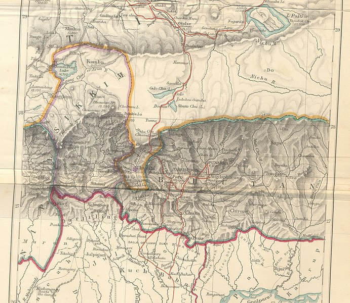
- 2009-10-14 10:25 Hindutashravi 4510×3916× (15480075 bytes) Historical Map of Sikkim in northeastern India extracted from map prepared by Trelawney Saunders, 1876 titled The routes of Bogle, Turner and Manning between Bengal and Tibet, and published in the book Titled, Narratives of the Mission of George Bogle
파일 역사
날짜/시간 링크를 클릭하면 해당 시간의 파일을 볼 수 있습니다.
| 날짜/시간 | 섬네일 | 크기 | 사용자 | 설명 | |
|---|---|---|---|---|---|
| 현재 | 2010년 6월 25일 (금) 16:38 | | 4,510 × 3,916 (14.76 MB) | File Upload Bot (Magnus Manske) | {{BotMoveToCommons|en.wikipedia|year={{subst:CURRENTYEAR}}|month={{subst:CURRENTMONTHNAME}}|day={{subst:CURRENTDAY}}}} {{Information |Description={{en|Historical Map of Sikkim in northeastern India extracted from map prepared by Trelawney Saunders, 1876 |
이 파일을 사용하는 문서
이 파일을 사용하는 문서가 없습니다.
이 파일을 사용하고 있는 모든 위키의 문서 목록
다음 위키에서 이 파일을 사용하고 있습니다:
- as.wikipedia.org에서 이 파일을 사용하고 있는 문서 목록
- bn.wikipedia.org에서 이 파일을 사용하고 있는 문서 목록
- en.wikipedia.org에서 이 파일을 사용하고 있는 문서 목록
- gu.wikipedia.org에서 이 파일을 사용하고 있는 문서 목록
- he.wikipedia.org에서 이 파일을 사용하고 있는 문서 목록
- hi.wikipedia.org에서 이 파일을 사용하고 있는 문서 목록
- id.wikipedia.org에서 이 파일을 사용하고 있는 문서 목록
- ja.wikipedia.org에서 이 파일을 사용하고 있는 문서 목록
- kn.wikipedia.org에서 이 파일을 사용하고 있는 문서 목록
- my.wikipedia.org에서 이 파일을 사용하고 있는 문서 목록
- nl.wikipedia.org에서 이 파일을 사용하고 있는 문서 목록
- pt.wikipedia.org에서 이 파일을 사용하고 있는 문서 목록
- sa.wikipedia.org에서 이 파일을 사용하고 있는 문서 목록
- si.wikipedia.org에서 이 파일을 사용하고 있는 문서 목록
- ta.wikipedia.org에서 이 파일을 사용하고 있는 문서 목록
- th.wikipedia.org에서 이 파일을 사용하고 있는 문서 목록
- vi.wikipedia.org에서 이 파일을 사용하고 있는 문서 목록