파일:Iceland (3), Reykjanes peninsula.JPG

미리 보기 크기: 800 × 531 픽셀 다른 해상도: 320 × 213 픽셀 | 640 × 425 픽셀 | 1,024 × 680 픽셀 | 1,280 × 850 픽셀 | 1,716 × 1,140 픽셀
원본 파일 (1,716 × 1,140 픽셀, 파일 크기: 672 KB, MIME 종류: image/jpeg)
,_Reykjanes_peninsula.JPG?uselang=ko)
파일 설명
| 설명 |
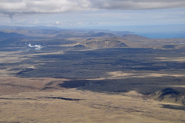
English: The Reykjanes Peninsula in Iceland is mostly a barren waste of lava fields. The steam on the left comes from the geothermal power station at Svartsengi. Surplus mineral rich and hot water from the plant fills up the Blue Lagoon, a tourist bathing resort.
Nederlands: Het schiereiland Reykjanes in IJsland bestaat grotendeels uit lavavelden, vrijwel zonder vegetatie. De stoompluimen (links) zijn afkomstig van de geothermische energiecentrale Svartsengi. Overtollig heet water van de centrale wordt gebruikt voor het nabijgelegen bad "Blue Lagoon", een toeristische trekpleister. |
| 날짜 | |
| 출처 | 자작 |
| 저자 | Vincent van Zeijst |
| 카메라 위치 | | 이 지역의 다른 사진을 보기: OpenStreetMap |
|---|
,_Reykjanes_peninsula.JPG¶ms=063.875761_N_-022.568664_E_globe:Earth_type:camera_region:IS_heading:90.00&language=ko)
Looking East.
라이선스
나는 아래 작품의 저작권자로서, 이 저작물을 다음과 같은 라이선스로 배포합니다:
이 파일은 크리에이티브 커먼즈 저작자표시 3.0 Unported 라이선스로 배포됩니다.
- 이용자는 다음의 권리를 갖습니다:
- 공유 및 이용 – 저작물의 복제, 배포, 전시, 공연 및 공중송신
- 재창작 – 저작물의 개작, 수정, 2차적저작물 창작
- 다음과 같은 조건을 따라야 합니다:
- 저작자표시 – 적절한 저작자 표시를 제공하고, 라이센스에 대한 링크를 제공하고, 변경사항이 있는지를 표시해야 합니다. 당신은 합리적인 방식으로 표시할 수 있지만, 어떤 방식으로든 사용권 허가자가 당신 또는 당신의 사용을 지지하는 방식으로 표시할 수 없습니다.
| 주석 | 이 이미지에는 주석이 있습니다: 공용에서 주석을 보기 |
,_Reykjanes_peninsula.JPG)
파일 역사
날짜/시간 링크를 클릭하면 해당 시간의 파일을 볼 수 있습니다.
| 날짜/시간 | 섬네일 | 크기 | 사용자 | 설명 | |
|---|---|---|---|---|---|
| 현재 | 2011년 5월 23일 (월) 01:46 | | 1,716 × 1,140 (672 KB) | Loranchet | {{Information |Description ={{en|1=The Reykjanes Peninsula in Iceland is mostly a barren waste of lava fields. The steam on the left comes from the geothermal power station at Svartsengi. Surplus mineral rich and hot water from the plant fills up the B |
이 파일을 사용하는 문서
다음 문서 1개가 이 파일을 사용하고 있습니다:
이 파일을 사용하고 있는 모든 위키의 문서 목록
다음 위키에서 이 파일을 사용하고 있습니다:
- ar.wikipedia.org에서 이 파일을 사용하고 있는 문서 목록
- az.wikipedia.org에서 이 파일을 사용하고 있는 문서 목록
- ca.wikipedia.org에서 이 파일을 사용하고 있는 문서 목록
- ceb.wikipedia.org에서 이 파일을 사용하고 있는 문서 목록
- cs.wikipedia.org에서 이 파일을 사용하고 있는 문서 목록
- de.wikipedia.org에서 이 파일을 사용하고 있는 문서 목록
- en.wikipedia.org에서 이 파일을 사용하고 있는 문서 목록
- en.wikivoyage.org에서 이 파일을 사용하고 있는 문서 목록
- eo.wikipedia.org에서 이 파일을 사용하고 있는 문서 목록
- es.wikipedia.org에서 이 파일을 사용하고 있는 문서 목록
- eu.wikipedia.org에서 이 파일을 사용하고 있는 문서 목록
- fa.wikipedia.org에서 이 파일을 사용하고 있는 문서 목록
- fr.wikipedia.org에서 이 파일을 사용하고 있는 문서 목록
- ga.wikipedia.org에서 이 파일을 사용하고 있는 문서 목록
- gd.wikipedia.org에서 이 파일을 사용하고 있는 문서 목록
- gl.wikipedia.org에서 이 파일을 사용하고 있는 문서 목록
- he.wikipedia.org에서 이 파일을 사용하고 있는 문서 목록
- hy.wikipedia.org에서 이 파일을 사용하고 있는 문서 목록
- id.wikipedia.org에서 이 파일을 사용하고 있는 문서 목록
- it.wikipedia.org에서 이 파일을 사용하고 있는 문서 목록
- ja.wikipedia.org에서 이 파일을 사용하고 있는 문서 목록
- ka.wikipedia.org에서 이 파일을 사용하고 있는 문서 목록
- mk.wikipedia.org에서 이 파일을 사용하고 있는 문서 목록
- ml.wikipedia.org에서 이 파일을 사용하고 있는 문서 목록
- nl.wikipedia.org에서 이 파일을 사용하고 있는 문서 목록
- no.wikipedia.org에서 이 파일을 사용하고 있는 문서 목록
- os.wikipedia.org에서 이 파일을 사용하고 있는 문서 목록
- pl.wikipedia.org에서 이 파일을 사용하고 있는 문서 목록
- pnb.wikipedia.org에서 이 파일을 사용하고 있는 문서 목록
- pt.wikipedia.org에서 이 파일을 사용하고 있는 문서 목록
- ru.wikipedia.org에서 이 파일을 사용하고 있는 문서 목록
- sh.wikipedia.org에서 이 파일을 사용하고 있는 문서 목록
- uk.wikipedia.org에서 이 파일을 사용하고 있는 문서 목록
- vls.wikipedia.org에서 이 파일을 사용하고 있는 문서 목록
- www.wikidata.org에서 이 파일을 사용하고 있는 문서 목록
이 파일의 더 많은 사용 내역을 봅니다.
,_Reykjanes_peninsula.JPG)
,_Reykjanes_peninsula.JPG)