파일:Italy 1000 AD.svg

SVG 파일의 PNG 형식의 미리보기 크기: 418 × 600 픽셀. 다른 해상도: 167 × 240 픽셀 | 334 × 480 픽셀 | 535 × 768 픽셀 | 713 × 1,024 픽셀 | 1,427 × 2,048 픽셀 | 565 × 811 픽셀
원본 파일 (SVG 파일, 실제 크기 565 × 811 픽셀, 파일 크기: 861 KB)
파일 설명
| 설명 |
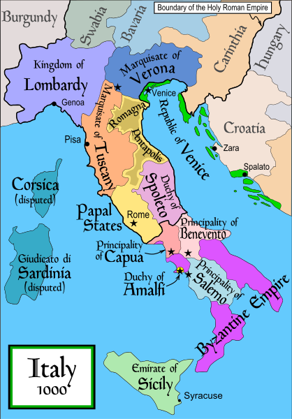
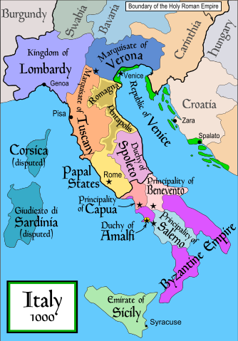
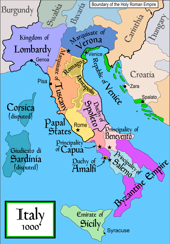
English: Political map of Italy in 1000 AD (CE). Created by MapMaster.
Part of a series of maps on the history of Italy:
|
| 날짜 | 2006년 11월 17일 (원본 올리기 일시) |
| 출처 | No machine-readable source provided. Own work assumed (based on copyright claims). |
| 저자 | No machine-readable author provided. MapMaster assumed (based on copyright claims). |
| 다른 버전 |
[]
SVG:
PNG:
|


|
이 SVG 파일은 편집 가능한 문자를 사용하므로 Inkscape나 Adobe Illustrator를 사용하여 쉽게 다른 언어로 번역할 수 있습니다. 여기를 참고하세요. 또한 텍스트 편집기를 이용하여 수동으로 파일을 번역할 수도 있습니다. |
References
- Bjorklund, Oddvar; Holmboe, Haakon; Rohr, Anders (1970) Historical Atlas of the World, Barnes & Noble, NY, SBN: 389-00253-4.
- This map from Allyn & Bacon, Longman, textbook publishers.
- This map of the w:en:Holy Roman Empire
- A map from Attilios
- This map of 1050 AD Italy, from the 1923 The Historical Atlas by William R. Shepherd
- This map of 1000 AD Italy from Fordham University, adapted from Muir's Historical Atlas, (1911).
In addition, a number of other sources were consulted in an effort to determine the following matters:
- The extent of Venetian control over the cities of Dalmatia such as Zara and Spalato. Although the Venetians had been pushed off the mainland earlier, in the period around the year 1000, the Venetians made an effort to recover these cities.
- The extent of Saracen control over Corsica and Sardinia. Information is sparse. The apparent situation is that the Muslims had several bases on the coasts of these islands, but did not control the countryside (such as they did in Sicily).
- Whether or not the principalities of Capua and Benevento were separate states in the year 1000. Based on lists of their rulers (various Pandulfs and Landulfs), the answer seems to be "yes".
- Who controlled the Balkans on the southeastern border of the Kingdom of Croatia. Candidates include Bulgaria, the Byzantine Empire, Croatia, and Serbia.
As noted, there is significant disagreement among sources on these questions.
This map was commissioned by Attilios, and there is also a discussion to be found on MapMaster's English talk page.
라이선스
나는 아래 작품의 저작권자로서, 이 저작물을 다음과 같은 라이선스로 배포합니다:

|
GNU 자유 문서 사용 허가서 1.2판 또는 자유 소프트웨어 재단에서 발행한 이후 판의 규정에 따라 본 문서를 복제하거나 개작 및 배포할 수 있습니다. 본 문서에는 변경 불가 부분이 없으며, 앞 표지 구절과 뒷 표지 구절도 없습니다. 본 사용 허가서의 전체 내용은 GNU 자유 문서 사용 허가서 부분에 포함되어 있습니다. |
| 이 파일은 크리에이티브 커먼즈 저작자표시-동일조건변경허락 3.0 Unported 라이선스로 배포됩니다. | ||
| ||
| 이 라이선스 틀은 GFDL 라이선스 변경의 일부로 이 파일에 추가되었습니다. |
derivative works
이 파일은 다음으로 파생됨: Italya MS 1000.svg
파일 역사
날짜/시간 링크를 클릭하면 해당 시간의 파일을 볼 수 있습니다.
| 날짜/시간 | 섬네일 | 크기 | 사용자 | 설명 | |
|---|---|---|---|---|---|
| 현재 | 2007년 4월 18일 (수) 04:50 | | 565 × 811 (861 KB) | MapMaster | Some further changes |
| 2007년 2월 19일 (월) 14:10 |  | 565 × 811 (824 KB) | MapMaster | changes to ensure consistency with my other Italy maps | |
| 2006년 11월 25일 (토) 14:39 |  | 565 × 811 (823 KB) | MapMaster | Improved map. | |
| 2006년 11월 18일 (토) 23:44 |  | 565 × 811 (827 KB) | MapMaster | Improved (I hope) version based on recommendations from Attilios. | |
| 2006년 11월 18일 (토) 06:50 |  | 565 × 811 (768 KB) | MapMaster | Political map of Italy in 1000 AD (CE). |
이 파일을 사용하는 문서
다음 문서 1개가 이 파일을 사용하고 있습니다:
이 파일을 사용하고 있는 모든 위키의 문서 목록
다음 위키에서 이 파일을 사용하고 있습니다:
- an.wikipedia.org에서 이 파일을 사용하고 있는 문서 목록
- ar.wikipedia.org에서 이 파일을 사용하고 있는 문서 목록
- ast.wikipedia.org에서 이 파일을 사용하고 있는 문서 목록
- azb.wikipedia.org에서 이 파일을 사용하고 있는 문서 목록
- az.wikipedia.org에서 이 파일을 사용하고 있는 문서 목록
- bg.wikipedia.org에서 이 파일을 사용하고 있는 문서 목록
- bn.wikipedia.org에서 이 파일을 사용하고 있는 문서 목록
- bs.wikipedia.org에서 이 파일을 사용하고 있는 문서 목록
- ckb.wikipedia.org에서 이 파일을 사용하고 있는 문서 목록
- cs.wikipedia.org에서 이 파일을 사용하고 있는 문서 목록
- da.wikipedia.org에서 이 파일을 사용하고 있는 문서 목록
- de.wikipedia.org에서 이 파일을 사용하고 있는 문서 목록
- el.wikipedia.org에서 이 파일을 사용하고 있는 문서 목록
- en.wikipedia.org에서 이 파일을 사용하고 있는 문서 목록
- Lombards
- Pope Stephen IX
- Otto III, Holy Roman Emperor
- Otto II, Holy Roman Emperor
- Salerno
- Benevento
- Emirate
- Italian city-states
- List of historical states of Italy
- List of state leaders in the 10th century
- Duchy of Spoleto
- Duchy of Benevento
- Kalbids
- Guaimar IV of Salerno
- Rainulf Drengot
- Duchy of Amalfi
- Emirate of Sicily
- Sergius IV of Naples
이 파일의 더 많은 사용 내역을 봅니다.