파일:Kingdoms around Israel 830 map.svg

SVG 파일의 PNG 형식의 미리보기 크기: 502 × 599 픽셀. 다른 해상도: 201 × 240 픽셀 | 402 × 480 픽셀 | 644 × 768 픽셀 | 858 × 1,024 픽셀 | 1,717 × 2,048 픽셀 | 720 × 859 픽셀
원본 파일 (SVG 파일, 실제 크기 720 × 859 픽셀, 파일 크기: 122 KB)
| 설명 |
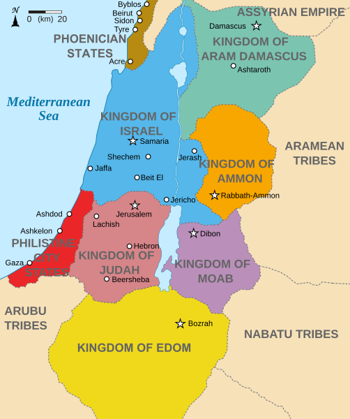
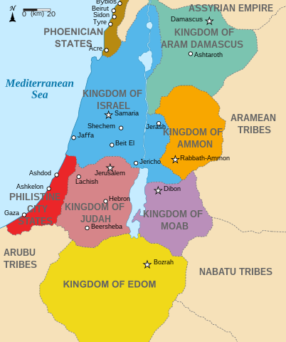
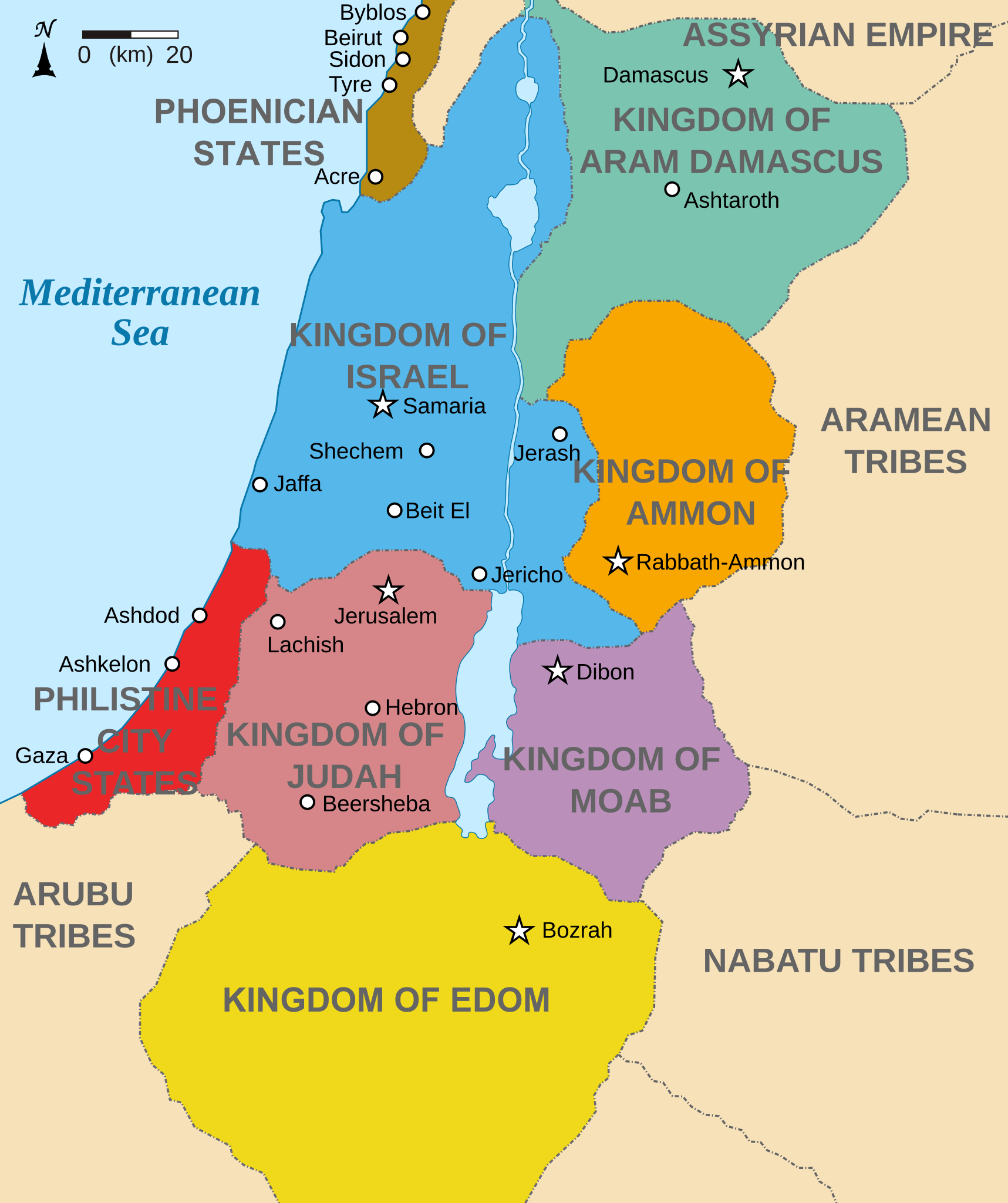
English: Map showing states around Israel & Judah. The Kingdoms around Israel & Judah are colored:
|
| 날짜 | (UTC) |
| 출처 | |
| 저자 |
|
| 다른 버전 |
[]
|


나는 아래 작품의 저작권자로서, 이 저작물을 다음과 같은 라이선스로 배포합니다:
이 파일은 크리에이티브 커먼즈 저작자표시-동일조건변경허락 3.0 Unported 라이선스로 배포됩니다.
- 이용자는 다음의 권리를 갖습니다:
- 공유 및 이용 – 저작물의 복제, 배포, 전시, 공연 및 공중송신
- 재창작 – 저작물의 개작, 수정, 2차적저작물 창작
- 다음과 같은 조건을 따라야 합니다:
- 저작자표시 – 적절한 저작자 표시를 제공하고, 라이센스에 대한 링크를 제공하고, 변경사항이 있는지를 표시해야 합니다. 당신은 합리적인 방식으로 표시할 수 있지만, 어떤 방식으로든 사용권 허가자가 당신 또는 당신의 사용을 지지하는 방식으로 표시할 수 없습니다.
- 동일조건변경허락 – 만약 당신이 이 저작물을 리믹스 또는 변형하거나 이 저작물을 기반으로 제작하는 경우, 당신은 당신의 기여물을 원저작물과 동일하거나 호환 가능한 라이선스에 따라 배포하여야 합니다.

|
GNU 자유 문서 사용 허가서 1.2판 또는 자유 소프트웨어 재단에서 발행한 이후 판의 규정에 따라 본 문서를 복제하거나 개작 및 배포할 수 있습니다. 본 문서에는 변경 불가 부분이 없으며, 앞 표지 구절과 뒷 표지 구절도 없습니다. 본 사용 허가서의 전체 내용은 GNU 자유 문서 사용 허가서 부분에 포함되어 있습니다. |
이 라이선스 중에서 목적에 맞는 것을 선택하여 사용할 수 있습니다.
기존 올리기 기록
This image is a derivative work of the following images:
- File:Kingdoms_of_Israel_and_Judah_map_830.svg licensed with Cc-by-sa-3.0, GFDL
- 2010-07-13T10:51:49Z Richardprins 720x859 (80858 Bytes) Added colors for the two kingdoms and converted their text to path and arial
- 2010-07-12T23:53:35Z Richardprins 720x859 (63843 Bytes) Shrinked down the borders
- 2010-07-12T19:43:31Z Richardprins 720x859 (63800 Bytes) {{Information |Description={{en|1=Map showing the ancient levant borders and ancient cities such as [[Urmomium]] and [[Jerash]]. The map also shows the region in the 9th century BCE. Notice the coastal land of Philistia, from
Uploaded with derivativeFX
파일 역사
날짜/시간 링크를 클릭하면 해당 시간의 파일을 볼 수 있습니다.
| 날짜/시간 | 섬네일 | 크기 | 사용자 | 설명 | |
|---|---|---|---|---|---|
| 현재 | 2022년 10월 30일 (일) 00:32 | | 720 × 859 (122 KB) | Muchado | Fixing font problems (hopefully) |
| 2022년 10월 30일 (일) 00:11 |  | 720 × 859 (283 KB) | Muchado | Added "Philistine City States" which was unintentionally missed off... | |
| 2022년 10월 30일 (일) 00:06 |  | 720 × 859 (239 KB) | Muchado | Coloured states, removed anachronistic Petra, added Bozrah, removed Urmomium (Your mom...!), edited Arabu to Arubu, edited to Philistine City States | |
| 2017년 2월 11일 (토) 00:51 |  | 720 × 859 (167 KB) | Malus Catulus | Removed 'Sizu' - a weird artifact from the Norse original | |
| 2010년 7월 13일 (화) 21:58 |  | 720 × 859 (165 KB) | Malus Catulus | livened up the colors, converted med sea text to path | |
| 2010년 7월 13일 (화) 20:26 |  | 720 × 859 (139 KB) | Malus Catulus | {{Information |Description={{en|1=Map showing the ancient levant borders and ancient cities such as Urmomium and Jerash. The Kingdoms around Israel and Judah are colored. The map also shows the region in the 9th century BCE. Notice the coastal lan |
이 파일을 사용하는 문서
다음 문서 5개가 이 파일을 사용하고 있습니다:
이 파일을 사용하고 있는 모든 위키의 문서 목록
다음 위키에서 이 파일을 사용하고 있습니다:
- af.wikipedia.org에서 이 파일을 사용하고 있는 문서 목록
- arc.wikipedia.org에서 이 파일을 사용하고 있는 문서 목록
- ar.wikipedia.org에서 이 파일을 사용하고 있는 문서 목록
- arz.wikipedia.org에서 이 파일을 사용하고 있는 문서 목록
- azb.wikipedia.org에서 이 파일을 사용하고 있는 문서 목록
- bg.wikipedia.org에서 이 파일을 사용하고 있는 문서 목록
- bn.wikipedia.org에서 이 파일을 사용하고 있는 문서 목록
- br.wikipedia.org에서 이 파일을 사용하고 있는 문서 목록
- ca.wikipedia.org에서 이 파일을 사용하고 있는 문서 목록
- cs.wikipedia.org에서 이 파일을 사용하고 있는 문서 목록
- da.wikipedia.org에서 이 파일을 사용하고 있는 문서 목록
- en.wikipedia.org에서 이 파일을 사용하고 있는 문서 목록
- Ammon
- History of the ancient Levant
- Kingdom of Judah
- Kingdom of Israel (Samaria)
- Philistines
- Moab
- Philistia
- Talk:Phoenician language
- Aram-Damascus
- Edom
- Portal:Bible/Featured chapter/Psalms
- Portal:Bible/Featured chapter/Psalms 83
- User:Kazkaskazkasako/Books/History
- Transjordan (region)
- Ezekiel 25
- User:Falcaorib
- User:Jacksonmcdonald3425/sandbox
- en.wiktionary.org에서 이 파일을 사용하고 있는 문서 목록
- eo.wikipedia.org에서 이 파일을 사용하고 있는 문서 목록
- et.wikipedia.org에서 이 파일을 사용하고 있는 문서 목록
- eu.wikipedia.org에서 이 파일을 사용하고 있는 문서 목록
이 파일의 더 많은 사용 내역을 봅니다.