파일:Liquid lakes on titan.jpg

미리 보기 크기: 458 × 599 픽셀 다른 해상도: 183 × 240 픽셀 | 367 × 480 픽셀 | 587 × 768 픽셀 | 783 × 1,024 픽셀 | 1,566 × 2,048 픽셀 | 2,600 × 3,400 픽셀
원본 파일 (2,600 × 3,400 픽셀, 파일 크기: 1.12 MB, MIME 종류: image/jpeg)
|
파일 설명
| 설명 |
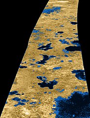
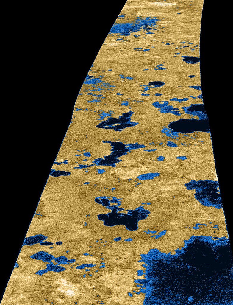
English: Radar image of the Titan surface taken on 22. July 2006 from Cassini probe. We can see liquid lakes of methane in this picture. The image is centered near 80 degrees north, 35 degrees west and is about 140 kilometers (84 miles) across. Smallest details in this image are about 500 meters (1,640 feet) across. The colours are not true.
The view is from Bolsena Lacus in the lower right to Mackay Lacus in the upper left. The names of some of the other laci in the image are given in this map. Some of the features in this image have been annotated in Wikimedia Commons.Deutsch: Seen aus flüssigem Methan auf dem Saturn-Mond Titan. Das Bild zeigt ein etwa 140 Kilometer breites Gebiet nahe 80° Nord 35° West. Falschfarben-Radaraufnahme von Cassini, 2006.
Italiano: Immagine radar in falsi colori della superficie di Titano ripresa il 22 luglio 2006 dalla sonda Cassini; si possono osservare laghi di metano liquido. L'immagine è centrata circa su 80 gradi nord, 35 gradi ovest e copre una vista di circa 140 km. I dettagli più piccoli in questa immagine hanno dimensione di circa 500 metri.
La vista parte dal Bolsena Lacus, in basso a destra, fino al Mackay Lacus in alto a sinistra. |
| 날짜 | |
| 출처 | http://photojournal.jpl.nasa.gov/catalog/PIA09102 |
| 저자 | NASA / JPL-Caltech / USGS |
라이선스
| 이 파일은 NASA에서 제작하였으므로 퍼블릭 도메인입니다. NASA의 저작권 정책에 따르면 NASA의 자료는 명시하지 않는 이상 저작권의 보호를 받지 않습니다. (Template:PD-USGov, 또는 NASA 저작권 정책 문서, JPL 그림 사용 정책을 참고하세요.) | ||
 |
주의사항:
|
| 주석 | 이 이미지에는 주석이 있습니다: 공용에서 주석을 보기 |
파일 역사
날짜/시간 링크를 클릭하면 해당 시간의 파일을 볼 수 있습니다.
| 날짜/시간 | 섬네일 | 크기 | 사용자 | 설명 | |
|---|---|---|---|---|---|
| 현재 | 2007년 2월 24일 (토) 23:50 | | 2,600 × 3,400 (1.12 MB) | Kokorik | {{Information |Description=Radar image of the Titan surface taken on 22. february 2007 from Cassini probe. We can see liquid lakes of methane in this picture. The image is centered near 80 degrees north, 35 degrees west and is about 140 kilometers (84 mil |
이 파일을 사용하는 문서
다음 문서 1개가 이 파일을 사용하고 있습니다:
이 파일을 사용하고 있는 모든 위키의 문서 목록
다음 위키에서 이 파일을 사용하고 있습니다:
- af.wikipedia.org에서 이 파일을 사용하고 있는 문서 목록
- an.wikipedia.org에서 이 파일을 사용하고 있는 문서 목록
- ar.wikipedia.org에서 이 파일을 사용하고 있는 문서 목록
- azb.wikipedia.org에서 이 파일을 사용하고 있는 문서 목록
- be.wikipedia.org에서 이 파일을 사용하고 있는 문서 목록
- Партал:Астраномія
- Партал:Астраномія/Як я магу дапамагчы
- Тытан (спадарожнік)
- Мора Кракена
- Шаблон:Гідрасфера Тытана
- Гідрасфера Тытана
- Мора Лігеі
- Мора Пунгі
- Возера Абая (Тытан)
- Возера Альбана (Тытан)
- Возера Атытлан (Тытан)
- Возера Больсена (Тытан)
- Возера Венерн (Тытан)
- Возера Кардыэль (Тытан)
- Возера Каюга (Тытан)
- Возера Ківу (Тытан)
- Возера Кайтэрэ (Тытан)
- Возера Ланаа (Тытан)
- Возера Локтак (Тытан)
- Возера Макай (Тытан)
- Возера Міватн (Тытан)
- Возера Ней (Тытан)
- Возера Анейда (Тытан)
- Возера Ахрыд (Тытан)
- Возера Севан (Тытан)
- Возера Сатанера (Тытан)
- Возера Спароу (Тытан)
- Возера Тавада (Тытан)
- Возера Уўс
- Возера Уэйкэр (Тытан)
- Возера Фея (Тытан)
- Возера Фрымен (Тытан)
- Возера Хунін (Тытан)
- Возера Цзінбо (Тытан)
- Лакуна Атакама
- Лагуна Джэрыд
- Лагуна Мельгір
- Лакуна Нгамі
- Лагуна Рэйстрэк
이 파일의 더 많은 사용 내역을 봅니다.