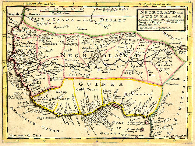
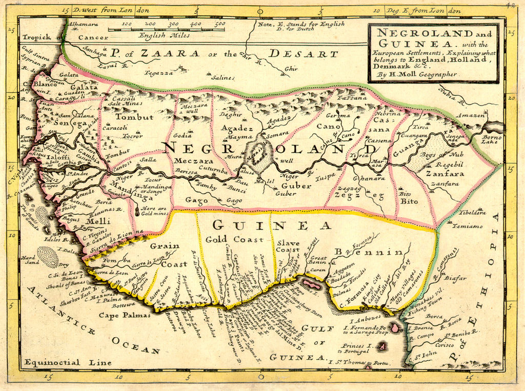
파일:Negroland and Guinea with the European Settlements, 1736.jpg

미리 보기 크기: 800 × 596 픽셀 다른 해상도: 320 × 238 픽셀 | 640 × 477 픽셀 | 1,024 × 763 픽셀 | 1,200 × 894 픽셀
원본 파일 (1,200 × 894 픽셀, 파일 크기: 1.55 MB, MIME 종류: image/jpeg)
Map|thumb|alt=https://www.canva.com/design/DAEqyLnPwRY/share/preview?token=KSHUFcVdAgta6UUstYCF7w&role=EDITOR&utm_content=DAEqyLnPwRY&utm_campaign=designshare&utm_medium=link&utm_source=sharebutton%7CThis 1747 Map reflects the various Kingdoms. The Kingdom of Juda(h). Ouidah /ˈwiːdə/, also Whydah /ˈhwaɪdə/ ]]
파일 설명
| 설명 | Full title: 'Negroland and Guinea with the European Settlements, Explaining what belongs to England, Holland, Denmark, etc'. By H. Moll Geographer (Printed and sold by T. Bowles next ye Chapter House in St. Pauls Church yard, & I. Bowles at ye Black Horse in Cornhill, 1729, orig. published in 1727). [1] |
| 날짜 | |
| 출처 | University of Florida, George A. Smathers Libraries, historic African maps: 1729 Herman Moll (#ALW1663) |
| 저자 | Herman Moll |
라이선스
|
이 작품은 미국, 그리고 저작권 보호 기간이 저작자 사후 100년, 또는 그 이하인 모든 국가에서 퍼블릭 도메인입니다. | |
| 이 저작물은 모든 저작인접권을 포함한 저작권법하의 규제로부터 자유로운 것으로 확인되었습니다. | |
기존 올리기 기록
(All user names refer to en.wikipedia)
- 2006-06-13 23:18 LIL T 1200×894×8 (1624023 bytes)
파일 역사
날짜/시간 링크를 클릭하면 해당 시간의 파일을 볼 수 있습니다.
| 날짜/시간 | 섬네일 | 크기 | 사용자 | 설명 | |
|---|---|---|---|---|---|
| 현재 | 2008년 2월 3일 (일) 15:16 | | 1,200 × 894 (1.55 MB) | BetacommandBot | move approved by: User:Dcoetzee This image was moved from Image:ALW1663L.jpg {{Information |Description=Full title: 'Negroland and Guinea with the European Settlements, Explaining what belongs to England, Holland, Denmark, etc'. By [[:en:Herman |
이 파일을 사용하는 문서
이 파일을 사용하고 있는 모든 위키의 문서 목록
다음 위키에서 이 파일을 사용하고 있습니다:
- an.wikipedia.org에서 이 파일을 사용하고 있는 문서 목록
- ar.wikipedia.org에서 이 파일을 사용하고 있는 문서 목록
- ba.wikipedia.org에서 이 파일을 사용하고 있는 문서 목록
- be.wikipedia.org에서 이 파일을 사용하고 있는 문서 목록
- bn.wikipedia.org에서 이 파일을 사용하고 있는 문서 목록
- br.wikipedia.org에서 이 파일을 사용하고 있는 문서 목록
- bs.wikipedia.org에서 이 파일을 사용하고 있는 문서 목록
- ca.wikipedia.org에서 이 파일을 사용하고 있는 문서 목록
- ceb.wikipedia.org에서 이 파일을 사용하고 있는 문서 목록
- cs.wikipedia.org에서 이 파일을 사용하고 있는 문서 목록
- cv.wikipedia.org에서 이 파일을 사용하고 있는 문서 목록
- da.wikipedia.org에서 이 파일을 사용하고 있는 문서 목록
- de.wikipedia.org에서 이 파일을 사용하고 있는 문서 목록
- en.wikipedia.org에서 이 파일을 사용하고 있는 문서 목록
- eo.wikipedia.org에서 이 파일을 사용하고 있는 문서 목록
- es.wikipedia.org에서 이 파일을 사용하고 있는 문서 목록
- eu.wikipedia.org에서 이 파일을 사용하고 있는 문서 목록
- fa.wikipedia.org에서 이 파일을 사용하고 있는 문서 목록
- fi.wikipedia.org에서 이 파일을 사용하고 있는 문서 목록
- fr.wikipedia.org에서 이 파일을 사용하고 있는 문서 목록
이 파일의 더 많은 사용 내역을 봅니다.