파일:PIA02786 San Andreas Fault.jpg

원본 파일 (1,152 × 870 픽셀, 파일 크기: 191 KB, MIME 종류: image/jpeg)
파일 설명
| 설명 |
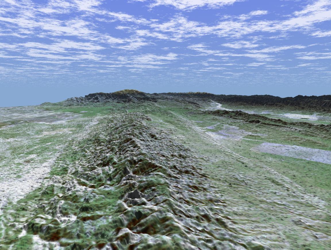
English: The 1,200-kilometer (800-mile)San Andreas is the longest fault in California and one of the longest in North America. This perspective view of a portion of the fault was generated using data from the Shuttle Radar Topography Mission (SRTM), which flew on NASA's Space Shuttle last February, and an enhanced, true-color Landsat satellite image. The view shown looks southeast along the San Andreas where it cuts along the base of the mountains in the Temblor Range near Bakersfield. The fault is the distinctively linear feature to the right of the mountains. To the left of the range is a portion of the agriculturally rich San Joaquin Valley. In the background is the snow-capped peak of Mt. Pinos at an elevation of 2,692 meters (8,831 feet). The complex topography in the area is some of the most spectacular along the course of the fault. To the right of the fault is the famous Carrizo Plain. Dry conditions on the plain have helped preserve the surface trace of the fault, which is scrutinized by both amateur and professional geologists. In 1857, one of the largest earthquakes ever recorded in the United States occurred just north of the Carrizo Plain. With an estimated magnitude of 8.0, the quake severely shook buildings in Los Angeles, caused significant surface rupture along a 350-kilometer (220-mile) segment of the fault, and was felt as far away as Las Vegas, Nev. This portion of the San Andreas is an important area of study for seismologists. For visualization purposes, topographic heights displayed in this image are exaggerated two times.
The elevation data used in this image was acquired by SRTM aboard the Space Shuttle Endeavour, launched on February 11, 2000. SRTM used the same radar instrument that comprised the Spaceborne Imaging Radar-C/X-Band Synthetic Aperture Radar (SIR-C/X-SAR) that flew twice on Endeavour in 1994. SRTM was designed to collect three-dimensional measurements of Earth's land surface. To collect the 3-D SRTM data, engineers added a mast 60 meters (about 200 feet) long, installed additional C-band and X-band antennas, and improved tracking and navigation devices. The mission is a cooperative project between the NASA, the National Imagery and Mapping Agency (NIMA) of the U.S. Department of Defense, and the German and Italian space agencies. It is managed by NASA's Jet Propulsion Laboratory, Pasadena, Calif, for NASA's Earth Science Enterprise, Washington, D.C. JPL is a division of the California Institute of Technology in Pasadena. Distance to Horizon: 73 kilometers (45.3 miles) Location: 35.42 deg. North lat., 119.5 deg. West lon. View: Toward the Southeast Date Acquired: February 16, 2000 SRTM, December 14, 1984 Landsat Image: NASA/JPL/NIMA |
| 날짜 | |
| 출처 | http://photojournal.jpl.nasa.gov/jpeg/PIA02786.jpg |
| 저자 | NASA/JPL |
라이선스
| 이 파일은 NASA에서 제작하였으므로 퍼블릭 도메인입니다. NASA의 저작권 정책에 따르면 NASA의 자료는 명시하지 않는 이상 저작권의 보호를 받지 않습니다. (Template:PD-USGov, 또는 NASA 저작권 정책 문서, JPL 그림 사용 정책을 참고하세요.) | ||
 |
주의사항:
|
파일 역사
날짜/시간 링크를 클릭하면 해당 시간의 파일을 볼 수 있습니다.
| 날짜/시간 | 섬네일 | 크기 | 사용자 | 설명 | |
|---|---|---|---|---|---|
| 현재 | 2015년 1월 2일 (금) 11:16 | | 1,152 × 870 (191 KB) | Jcpag2012 | User created page with UploadWizard |
이 파일을 사용하는 문서
다음 문서 1개가 이 파일을 사용하고 있습니다:
이 파일을 사용하고 있는 모든 위키의 문서 목록
다음 위키에서 이 파일을 사용하고 있습니다:
- en.wikipedia.org에서 이 파일을 사용하고 있는 문서 목록
- gl.wikipedia.org에서 이 파일을 사용하고 있는 문서 목록
- zh.wikipedia.org에서 이 파일을 사용하고 있는 문서 목록