파일:PIA16217-MarsCuriosityRover-1stXRayView-20121017.jpg

PIA16217-MarsCuriosityRover-1stXRayView-20121017.jpg (582 × 600 픽셀, 파일 크기: 154 KB, MIME 종류: image/jpeg)
파일 설명
| 설명 |
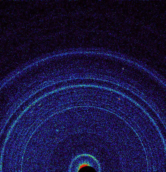
English: 10.30.2012
First X-ray View of Martian Soil http://photojournal.jpl.nasa.gov/catalog/PIA16217 This graphic shows results of the first analysis of Martian soil by the Chemistry and Mineralogy (CheMin) experiment on NASA's Curiosity rover. The image reveals the presence of crystalline feldspar, pyroxenes and olivine mixed with some amorphous (non-crystalline) material. The soil sample, taken from a wind-blown deposit within Gale Crater, where the rover landed, is similar to volcanic soils in Hawaii. Curiosity scooped the soil on Oct. 15, 2012, the 69th sol, or Martian day, of operations. It was delivered to CheMin for X-ray diffraction analysis on October 17, 2012, the 71st sol. By directing an X-ray beam at a sample and recording how X-rays are scattered by the sample at an atomic level, the instrument can definitively identify and quantify minerals on Mars for the first time. Each mineral has a unique pattern of rings, or "fingerprint," revealing its presence. The colors in the graphic represent the intensity of the X-rays, with red being the most intense. Image Credit: NASA/JPL-Caltech/Ames |
| 날짜 | |
| 출처 | http://photojournal.jpl.nasa.gov/jpeg/PIA16217.jpg |
| 저자 | NASA/JPL-Caltech/Ames |
라이선스
| 이 파일은 NASA에서 제작하였으므로 퍼블릭 도메인입니다. NASA의 저작권 정책에 따르면 NASA의 자료는 명시하지 않는 이상 저작권의 보호를 받지 않습니다. (Template:PD-USGov, 또는 NASA 저작권 정책 문서, JPL 그림 사용 정책을 참고하세요.) | ||
 |
주의사항:
|
파일 역사
날짜/시간 링크를 클릭하면 해당 시간의 파일을 볼 수 있습니다.
| 날짜/시간 | 섬네일 | 크기 | 사용자 | 설명 | |
|---|---|---|---|---|---|
| 현재 | 2012년 10월 31일 (수) 09:00 | | 582 × 600 (154 KB) | Drbogdan | User created page with UploadWizard |
이 파일을 사용하는 문서
다음 문서 1개가 이 파일을 사용하고 있습니다:
이 파일을 사용하고 있는 모든 위키의 문서 목록
다음 위키에서 이 파일을 사용하고 있습니다:
- ar.wikipedia.org에서 이 파일을 사용하고 있는 문서 목록
- beta.wikiversity.org에서 이 파일을 사용하고 있는 문서 목록
- bn.wikipedia.org에서 이 파일을 사용하고 있는 문서 목록
- ca.wikipedia.org에서 이 파일을 사용하고 있는 문서 목록
- el.wikipedia.org에서 이 파일을 사용하고 있는 문서 목록
- en.wikipedia.org에서 이 파일을 사용하고 있는 문서 목록
- en.wikiversity.org에서 이 파일을 사용하고 있는 문서 목록
- es.wikipedia.org에서 이 파일을 사용하고 있는 문서 목록
- fa.wikipedia.org에서 이 파일을 사용하고 있는 문서 목록
- he.wikipedia.org에서 이 파일을 사용하고 있는 문서 목록
- hr.wikipedia.org에서 이 파일을 사용하고 있는 문서 목록
- hy.wikipedia.org에서 이 파일을 사용하고 있는 문서 목록
- ja.wikipedia.org에서 이 파일을 사용하고 있는 문서 목록
- mk.wikipedia.org에서 이 파일을 사용하고 있는 문서 목록
- nl.wikipedia.org에서 이 파일을 사용하고 있는 문서 목록
- ps.wikipedia.org에서 이 파일을 사용하고 있는 문서 목록
- ro.wikipedia.org에서 이 파일을 사용하고 있는 문서 목록
- ru.wikipedia.org에서 이 파일을 사용하고 있는 문서 목록
이 파일의 더 많은 사용 내역을 봅니다.