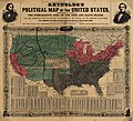
파일:Reynolds's Political Map of the United States 1856.jpg

미리 보기 크기: 661 × 600 픽셀 다른 해상도: 265 × 240 픽셀 | 529 × 480 픽셀 | 846 × 768 픽셀 | 1,128 × 1,024 픽셀 | 2,257 × 2,048 픽셀 | 7,813 × 7,090 픽셀
원본 파일 (7,813 × 7,090 픽셀, 파일 크기: 19.76 MB, MIME 종류: image/jpeg)
파일 역사
날짜/시간 링크를 클릭하면 해당 시간의 파일을 볼 수 있습니다.
| 날짜/시간 | 섬네일 | 크기 | 사용자 | 설명 | |
|---|---|---|---|---|---|
| 현재 | 2023년 8월 17일 (목) 03:29 |  | 7,813 × 7,090 (19.76 MB) | Jengod | Autotune so brighter and easier to read |
| 2016년 4월 22일 (금) 16:28 |  | 7,813 × 7,090 (35.27 MB) | Khamar | Original improved in Adobe Photoshop by removing white strip through center where left and right sides of map join, removing some dark and white stripes from image, and nudging some of the text and lines back into alignment preserving as much of the ma... | |
| 2012년 12월 17일 (월) 10:40 |  | 7,828 × 7,090 (16.56 MB) | T3hBra1nWa5her | Higher resolution version from the [http://memory.loc.gov/cgi-bin/query/h?ammem/gmd:@field(NUMBER+@band(g3701e+ct000604)) Library of Congress Geography and Map Division Washington]. | |
| 2008년 8월 1일 (금) 22:15 |  | 2,000 × 1,736 (709 KB) | Bdamokos | {{Information |Description={{en|US map 1856 shows free and slave states and populations; this is "Reynolds's Political Map of the United States" (1856) from Library of Congress collection[http://lcweb2.loc.gov/ammem/aaohtml/exhibit/aopart3b.html] [[:en |
이 파일을 사용하는 문서
다음 문서 1개가 이 파일을 사용하고 있습니다:
이 파일을 사용하고 있는 모든 위키의 문서 목록
다음 위키에서 이 파일을 사용하고 있습니다:
- ar.wikipedia.org에서 이 파일을 사용하고 있는 문서 목록
- ca.wikipedia.org에서 이 파일을 사용하고 있는 문서 목록
- de.wikipedia.org에서 이 파일을 사용하고 있는 문서 목록
- en.wikipedia.org에서 이 파일을 사용하고 있는 문서 목록
- en.wikiquote.org에서 이 파일을 사용하고 있는 문서 목록
- es.wikipedia.org에서 이 파일을 사용하고 있는 문서 목록
- fa.wikipedia.org에서 이 파일을 사용하고 있는 문서 목록
- fi.wikipedia.org에서 이 파일을 사용하고 있는 문서 목록
- fr.wikipedia.org에서 이 파일을 사용하고 있는 문서 목록
- he.wikipedia.org에서 이 파일을 사용하고 있는 문서 목록
- hu.wikipedia.org에서 이 파일을 사용하고 있는 문서 목록
- id.wikipedia.org에서 이 파일을 사용하고 있는 문서 목록
- it.wikipedia.org에서 이 파일을 사용하고 있는 문서 목록
- ja.wikipedia.org에서 이 파일을 사용하고 있는 문서 목록
- no.wikipedia.org에서 이 파일을 사용하고 있는 문서 목록
- pl.wikipedia.org에서 이 파일을 사용하고 있는 문서 목록
- pt.wikipedia.org에서 이 파일을 사용하고 있는 문서 목록
- ro.wikipedia.org에서 이 파일을 사용하고 있는 문서 목록
- ru.wikipedia.org에서 이 파일을 사용하고 있는 문서 목록
- sh.wikipedia.org에서 이 파일을 사용하고 있는 문서 목록
- simple.wikipedia.org에서 이 파일을 사용하고 있는 문서 목록
이 파일의 더 많은 사용 내역을 봅니다.