파일:Sedan Plowshare Crater.jpg
미리 보기 크기: 755 × 599 픽셀 다른 해상도: 302 × 240 픽셀 | 605 × 480 픽셀 | 968 × 768 픽셀 | 1,280 × 1,016 픽셀 | 1,426 × 1,132 픽셀
원본 파일 (1,426 × 1,132 픽셀, 파일 크기: 202 KB, MIME 종류: image/jpeg)
|
This is an image of a place or building that is listed on the National Register of Historic Places in the United States of America. Its reference number is 94000183. |
| 설명 |
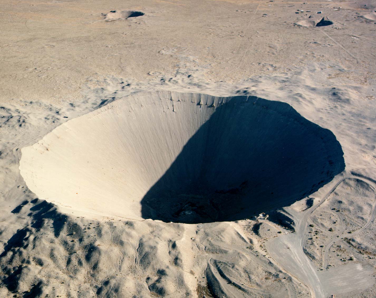
English: Crater from the 1962 "Sedan" nuclear test as part of Operation Plowshare. The 104 kiloton blast displaced 12 million tons of earth and created a crater 320 feet deep and 1,280 feet wide. (Look to the size of the roads in the bottom-right of the picture, and the observation deck at the lower-right edge of the crater, for a sense of scale) العربية: فوهة بركان سيدان هي نتيجة اختبار سيدان النووي ويقع داخل موقع اختبار نيفادا، على بعد 12 ميلاً (19 كم) جنوب غرب بحيرة جرووم |
|
| 출처 |
|
|
| 저자 | Federal Government of the United States |
| 카메라 위치 | | 이 지역의 다른 사진을 보기: OpenStreetMap |
|---|
이 이미지는 2006년 1월 27일의 오늘의 이미지로 선정되었습니다. 이미지 설명은 다음과 같습니다. 한국어: 네바다 핵실험 장소에 있는 폭탄 구멍. 다른 언어들:
Čeština: Kráter po zkušebním jaderném výbuchu v Nevadě. Cymraeg: Crater oddiwrth brawf niwcliar yn y Seit Profi Nevada. Dansk: Krater fra en kernevåben-test i testområdet i Nevada, USA. Deutsch: Krater von einem Nukleartest auf dem Nevadatestgelände English: Crater from a nuclear test at Nevada Test Site. Italiano: Cratere provocato da un test nucleare nel Nevada Test Site. Magyar: Egy nukleáris robbantás krátere. Nevada, USA. Nederlands: Krater als gevolg van een nucleaire test op de testvlakte in Nevada. Polski: Krater w strefie testów nuklearnych w stanie Nevada Slovenščina: Krater jedrskega preizkusa na preizkuševalnem območju Nevada. ગુજરાતી : નેવાડાના ન્યુક્લિયર પરિક્ષણ મથક પર ભૂગર્ભ પરિક્ષણ બાદ રહેલો ખાડો. 한국어: 네바다 핵실험 장소에 있는 폭탄 구멍. العربية : حفرة هائلة جراء انفجار نووي في منطقة الاختبارات النووية بولاية نيفادا الأمريكية |
이 파일은 미국 법전 제17편 제1장 제105조에 따른 미국 연방정부의 공무원 또는 피고용인이 공무상 작성한 저작물로, 미국에서 퍼블릭 도메인입니다.
주의: 본 라이선스는 미국 연방정부의 저작물에 관해서만 효력이 있습니다. 미국의 주, 군, 기타 지방자치단체가 만든 저작물에 대해서는 적용되지 않습니다. 또한 미국 우정청이 1978년부터 발행한 우표 디자인에도 적용되지 않습니다.
|
 | |
| 이 저작물은 모든 저작인접권을 포함한 저작권법하의 규제로부터 자유로운 것으로 확인되었습니다. | ||
파일 역사
날짜/시간 링크를 클릭하면 해당 시간의 파일을 볼 수 있습니다.
| 날짜/시간 | 섬네일 | 크기 | 사용자 | 설명 | |
|---|---|---|---|---|---|
| 현재 | 2005년 12월 12일 (월) 02:49 | | 1,426 × 1,132 (202 KB) | Fastfission~commonswiki | even higher res |
| 2005년 5월 23일 (월) 05:30 |  | 685 × 543 (338 KB) | Xenoforme~commonswiki |
이 파일을 사용하는 문서
다음 문서 3개가 이 파일을 사용하고 있습니다:
이 파일을 사용하고 있는 모든 위키의 문서 목록
다음 위키에서 이 파일을 사용하고 있습니다:
- af.wikipedia.org에서 이 파일을 사용하고 있는 문서 목록
- ar.wikipedia.org에서 이 파일을 사용하고 있는 문서 목록
- beta.wikiversity.org에서 이 파일을 사용하고 있는 문서 목록
- bg.wikipedia.org에서 이 파일을 사용하고 있는 문서 목록
- ca.wikipedia.org에서 이 파일을 사용하고 있는 문서 목록
- ceb.wikipedia.org에서 이 파일을 사용하고 있는 문서 목록
- cs.wikipedia.org에서 이 파일을 사용하고 있는 문서 목록
- de.wikipedia.org에서 이 파일을 사용하고 있는 문서 목록
- de.wiktionary.org에서 이 파일을 사용하고 있는 문서 목록
- en.wikipedia.org에서 이 파일을 사용하고 있는 문서 목록
- Nuclear explosive
- Nevada Test Site
- Project Plowshare
- Nuclear weapons testing
- Sedan (nuclear test)
- Wikipedia:Recent additions 26
- Peaceful nuclear explosion
- Underground nuclear weapons testing
- Craterization
- Yucca Flat
- Explosion crater
- Wikipedia:Did you know/Statistics/Monthly DYK pageview leaders/2008
- Wikipedia:Recent additions/2005/March
- User:Binksternet/DYK
- Wikipedia:Recent additions/2008/July
- July 1962
- National Register of Historic Places listings in Nye County, Nevada
- User:Boundarylayer/sandbox
- User:Epicgenius/Userpage/Rest of year
- Crater
- User:Ikluft/essay/Categorization of craters
- History of the Petroleum industry in Alberta
- en.wikibooks.org에서 이 파일을 사용하고 있는 문서 목록
이 파일의 더 많은 사용 내역을 봅니다.