파일:Soviet caucasus1922.png

미리 보기 크기: 800 × 571 픽셀 다른 해상도: 320 × 229 픽셀 | 640 × 457 픽셀 | 1,024 × 731 픽셀 | 1,280 × 914 픽셀 | 1,613 × 1,152 픽셀
원본 파일 (1,613 × 1,152 픽셀, 파일 크기: 127 KB, MIME 종류: image/png)
파일 설명
| 설명 |
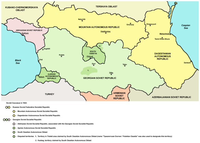
English: Northern part of Soviet Caucasus in 1922 - Mountain Autonomous Soviet Socialist Republic, Dagestanian Autonomous Soviet Socialist Republic, Georgian Soviet Socialist Republic, Abkhazian Soviet Socialist Republic, Ajarian Autonomous Soviet Socialist Republic, South Ossetian Autonomous Oblast and disputed territories claimed by South Ossetian Autonomous Oblast (Trialeti area / Trialetian Ossetia and Kazbeg). |
| 날짜 | |
| 출처 | 자작 |
| 저자 | PANONIAN |
| 다른 버전 |
|

라이선스
| 나는 이 작품의 저작권자로서, 이 작품을 퍼블릭 도메인으로 모두에게 공개합니다. 이 공개 선언은 전 세계적으로 유효합니다. 만약 저작권의 포기가 법률적으로 가능하지 않은 경우, 나는 이 작품을 법적으로 허용되는 한도 내에서 누구나 자유롭게 어떤 목적으로도 제한없이 사용할 수 있도록 허용합니다. |
References
Made according to these sources:
- http://www.iriston.com/books/cuciev_-_etno_atlas/cuciev_etno-polit_map.htm - 50 maps from book "АТЛАС ЭТНОПОЛИТИЧЕСКОЙ ИСТОРИИ КАВКАЗА", Цуциев А.А, Москва: Издательство «Европа», 2007. ("Atlas of ethnopolitical history of Caucasus", Tsutsiev A.A, Moscow: Publisher «Evropa», 2007), inluding a map of Soviet Caucasus in 1921, which show Mountain Autonomous Soviet Socialist Republic, Dagestanian Autonomous Soviet Socialist Republic, Georgian Soviet Socialist Republic, Abkhazian Soviet Socialist Republic, Ajarian Autonomous Soviet Socialist Republic, and disputed territories inhabited by Ossetians: South Ossetia, Trialetian Ossetia and Kazbeg.
- http://dic.academic.ru/pictures/wiki/files/84/Tsutsiev.jpg - map from book "АТЛАС ЭТНОПОЛИТИЧЕСКОЙ ИСТОРИИ КАВКАЗА", Цуциев А.А ("Atlas of ethnopolitical history of Caucasus", Tsutsiev A.A), inluding a map of Soviet Caucasus in 1921, which show Mountain Autonomous Soviet Socialist Republic, Dagestanian Autonomous Soviet Socialist Republic, Georgian Soviet Socialist Republic, Abkhazian Soviet Socialist Republic, Ajarian Autonomous Soviet Socialist Republic, and disputed territories inhabited by Ossetians: South Ossetia, Trialetian Ossetia and Kazbeg.
- http://www.iriston.com/nogbon/pictures/Tabol/cuciev_karta_6.jpg - map of Soviet Caucasus in 1922, created by Tsutsiev A.A, which show Mountain Autonomous Soviet Socialist Republic and South Ossetian Autonomous Oblast.
파일 역사
날짜/시간 링크를 클릭하면 해당 시간의 파일을 볼 수 있습니다.
| 날짜/시간 | 섬네일 | 크기 | 사용자 | 설명 | |
|---|---|---|---|---|---|
| 현재 | 2015년 12월 27일 (일) 02:03 | | 1,613 × 1,152 (127 KB) | PANONIAN | Reverted to version as of 14:47, 27 March 2010 (UTC) - please upload your version under different filename |
| 2015년 12월 26일 (토) 19:56 |  | 1,613 × 1,090 (115 KB) | Ercwlff | corrected georgian city names | |
| 2015년 12월 26일 (토) 19:45 |  | 1,613 × 1,090 (114 KB) | Ercwlff | corrected | |
| 2015년 12월 26일 (토) 19:42 |  | 1,613 × 1,090 (117 KB) | Ercwlff | ~~~~ | |
| 2010년 3월 27일 (토) 23:47 |  | 1,613 × 1,152 (127 KB) | PANONIAN | on the second thought, this map is focused on the history of Ossetians and other north Caucasian peoples and therefore disputes areas claimed by Armenia and Azerbaijan are not very relevant subject here | |
| 2010년 3월 27일 (토) 07:04 |  | 1,613 × 1,216 (134 KB) | PANONIAN | corrected one description | |
| 2010년 3월 26일 (금) 07:54 |  | 1,613 × 1,216 (132 KB) | PANONIAN | new version | |
| 2010년 3월 24일 (수) 08:52 |  | 1,613 × 1,122 (121 KB) | PANONIAN | correction | |
| 2010년 3월 24일 (수) 03:51 |  | 1,613 × 1,122 (121 KB) | PANONIAN | significant improvement - I hope that this is a final version | |
| 2010년 3월 24일 (수) 01:32 |  | 1,227 × 915 (88 KB) | PANONIAN | corrections |
이 파일을 사용하는 문서
다음 문서 2개가 이 파일을 사용하고 있습니다:
이 파일을 사용하고 있는 모든 위키의 문서 목록
다음 위키에서 이 파일을 사용하고 있습니다:
- ar.wikipedia.org에서 이 파일을 사용하고 있는 문서 목록
- ast.wikipedia.org에서 이 파일을 사용하고 있는 문서 목록
- bg.wikipedia.org에서 이 파일을 사용하고 있는 문서 목록
- bn.wikipedia.org에서 이 파일을 사용하고 있는 문서 목록
- br.wikipedia.org에서 이 파일을 사용하고 있는 문서 목록
- ca.wikipedia.org에서 이 파일을 사용하고 있는 문서 목록
- ce.wikipedia.org에서 이 파일을 사용하고 있는 문서 목록
- de.wikipedia.org에서 이 파일을 사용하고 있는 문서 목록
- en.wikipedia.org에서 이 파일을 사용하고 있는 문서 목록
- eo.wikipedia.org에서 이 파일을 사용하고 있는 문서 목록
- es.wikipedia.org에서 이 파일을 사용하고 있는 문서 목록
- et.wikipedia.org에서 이 파일을 사용하고 있는 문서 목록
- fi.wikipedia.org에서 이 파일을 사용하고 있는 문서 목록
- fr.wikipedia.org에서 이 파일을 사용하고 있는 문서 목록
- it.wikipedia.org에서 이 파일을 사용하고 있는 문서 목록
- ja.wikipedia.org에서 이 파일을 사용하고 있는 문서 목록
- kk.wikipedia.org에서 이 파일을 사용하고 있는 문서 목록
- ku.wikipedia.org에서 이 파일을 사용하고 있는 문서 목록
- lt.wikipedia.org에서 이 파일을 사용하고 있는 문서 목록
- lv.wikipedia.org에서 이 파일을 사용하고 있는 문서 목록
- mk.wikipedia.org에서 이 파일을 사용하고 있는 문서 목록
- no.wikipedia.org에서 이 파일을 사용하고 있는 문서 목록
- os.wikipedia.org에서 이 파일을 사용하고 있는 문서 목록
- pl.wikipedia.org에서 이 파일을 사용하고 있는 문서 목록
이 파일의 더 많은 사용 내역을 봅니다.