파일:TY Xangsane 20061001 land.jpg

원본 파일(4,000 × 4,000 픽셀, 파일 크기: 1.48 MB, MIME 종류: image/jpeg)

파일 설명

설명

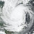
Typhoon Xangsane formed on September 25, 2006, in the western Pacific near the coast of the Philippine Islands. Over the next 36 hours, it grew from a tropical depression (area of low air pressure) to a typhoon. The typhoon crossed the Philippines and was credited for causing 76 deaths there before crossing the South China Sea and coming ashore in central Vietnam on October 1, according to the Agence France-Presse news service. As the storm came ashore in central Vietnam, it packed winds of 148 kilometers per hour (92 miles per hour), causing another six deaths and many injuries. Vietnamese authorities called Typhoon Xangsane the biggest storm to hit the country in several decades.

This photo-like image was acquired by the Moderate Resolution Imaging Spectroradiometer (MODIS) on the Terra satellite on October 1, 2006, at 10:10 a.m. local time (03:10 UTC). Xangsane at the time of this image was a well-defined spiral of clouds, but other typhoon characteristics were not obvious. It lacked a well-defined eye, and the spiral arms of the storm did not have sharp edges or evidence of strong thunderstorms. Much of the initial power of the storm had apparently been sapped as the typhoon came over land.
날짜
출처 NASA Earth Observatory Natural Hazards: Typhoon Xangsane
저자 NASA image created by Jesse Allen, Earth Observatory, using data provided courtesy of the MODIS Rapid Response team.
저작권
(이 파일을 인용하기)
Public domain 이 파일은 NASA에서 제작하였으므로 퍼블릭 도메인입니다. NASA의 저작권 정책에 따르면 NASA의 자료는 명시하지 않는 이상 저작권의 보호를 받지 않습니다. (Template:PD-USGov, 또는 NASA 저작권 정책 문서, JPL 그림 사용 정책을 참고하세요.)
주의사항:

설명

이 파일이 나타내는 바에 대한 한 줄 설명을 추가합니다

이 파일에 묘사된 항목

다음을 묘사함

파일 역사

날짜/시간 링크를 클릭하면 해당 시간의 파일을 볼 수 있습니다.

날짜/시간섬네일크기사용자설명
현재2006년 10월 10일 (화) 00:372006년 10월 10일 (화) 00:37 판의 섬네일4,000 × 4,000 (1.48 MB)Nilfanionfix progressive jpg (right file this time..)
2006년 10월 8일 (일) 14:502006년 10월 8일 (일) 14:50 판의 섬네일4,000 × 4,000 (2.98 MB)Coredesat{{Information |Description=NASA MODIS image of Typhoon Xangsane shortly after landfall in Vietnam on October 1, 2006. |Source=[http://earthobservatory.nasa.gov/NaturalHazards/natural_hazards_v2.php3?img_id=13913 NASA Earth Observatory Natural Hazards: Typ

다음 문서 1개가 이 파일을 사용하고 있습니다:

이 파일을 사용하고 있는 모든 위키의 문서 목록

다음 위키에서 이 파일을 사용하고 있습니다:

  • en.wikipedia.org에서 이 파일을 사용하고 있는 문서 목록
  • pt.wikipedia.org에서 이 파일을 사용하고 있는 문서 목록

메타데이터