파일:Tanggu Truce Map.jpg

미리 보기 크기: 794 × 600 픽셀 다른 해상도: 318 × 240 픽셀 | 635 × 480 픽셀 | 1,016 × 768 픽셀 | 1,280 × 967 픽셀 | 1,985 × 1,500 픽셀
원본 파일 (1,985 × 1,500 픽셀, 파일 크기: 403 KB, MIME 종류: image/jpeg)
파일 설명
| 설명 |
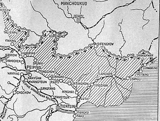
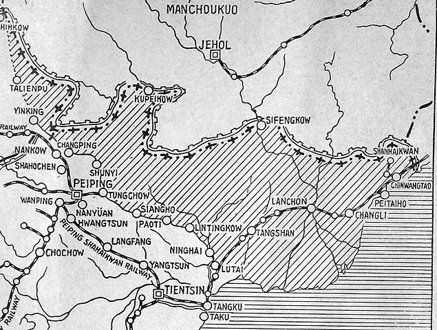
English: The shaded part of this map shows the areas demilitarized by the Tanggu Truce. Note also that the remainder of the Hebei Province, including Beijing and Tianjin, would also be demilitarized of Nationalist forces under the terms of the He-Umezu Agreement, but independent warlords like Song Zheyuan continued to operate there. |
| 날짜 | |
| 출처 | a pamphlet called "Sino-Japanese Conflict Elucidated" |
| 저자 | Canadian Japanese Association |
라이선스
This Canadian work, of which the author or authors are unknown, is in the public domain in Canada because:
(R.S.C., 2020, c. C-42, s. 6.1, R.S.C., 1993, c. C-42, s. 6.1) |
 | |
|
|
파일 역사
날짜/시간 링크를 클릭하면 해당 시간의 파일을 볼 수 있습니다.
| 날짜/시간 | 섬네일 | 크기 | 사용자 | 설명 | |
|---|---|---|---|---|---|
| 현재 | 2012년 10월 19일 (금) 07:47 | | 1,985 × 1,500 (403 KB) | CurtisNaito | User created page with UploadWizard |
이 파일을 사용하는 문서
다음 문서 1개가 이 파일을 사용하고 있습니다:
이 파일을 사용하고 있는 모든 위키의 문서 목록
다음 위키에서 이 파일을 사용하고 있습니다:
- ar.wikipedia.org에서 이 파일을 사용하고 있는 문서 목록
- en.wikipedia.org에서 이 파일을 사용하고 있는 문서 목록
- es.wikipedia.org에서 이 파일을 사용하고 있는 문서 목록
- fa.wikipedia.org에서 이 파일을 사용하고 있는 문서 목록
- fr.wikipedia.org에서 이 파일을 사용하고 있는 문서 목록
- it.wikipedia.org에서 이 파일을 사용하고 있는 문서 목록
- lv.wikipedia.org에서 이 파일을 사용하고 있는 문서 목록
- nl.wikipedia.org에서 이 파일을 사용하고 있는 문서 목록
- pt.wikipedia.org에서 이 파일을 사용하고 있는 문서 목록
- ru.wikipedia.org에서 이 파일을 사용하고 있는 문서 목록
- uk.wikipedia.org에서 이 파일을 사용하고 있는 문서 목록