파일:Thermohaline Circulation 2.png
미리 보기 크기: 800 × 502 픽셀 다른 해상도: 320 × 201 픽셀 | 640 × 401 픽셀 | 1,100 × 690 픽셀
원본 파일 (1,100 × 690 픽셀, 파일 크기: 122 KB, MIME 종류: image/png)
파일 설명
| 설명 |
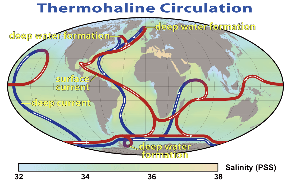
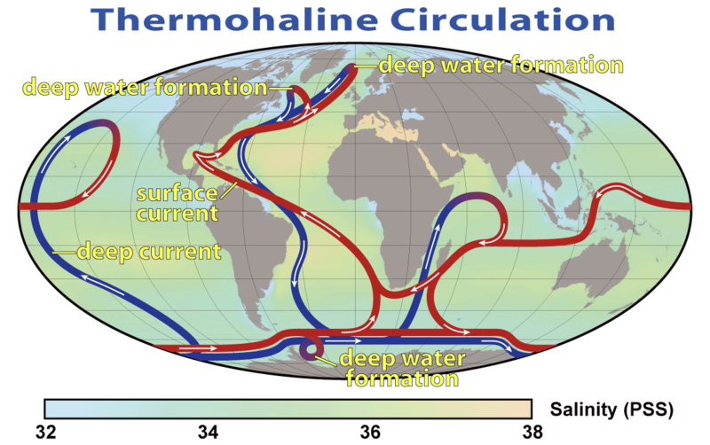
English: This map shows the pattern of thermohaline circulation also known as "meridional overturning circulation". This collection of currents is responsible for the large-scale exchange of water masses in the ocean, including providing oxygen to the deep ocean. The entire circulation pattern takes ~2000 years.
Deutsch: Thermohaline Zirkulation und die Entstehung von kaltem, dichtem Tiefenwasser im Nordmeer |
|||||
| 날짜 | ||||||
| 출처 | NASA Earth Observatory | |||||
| 저자 | Robert Simmon, NASA. Minor modifications by Robert A. Rohde also released to the public domain | |||||
| 저작권 (이 파일을 인용하기) |
|
|||||
| 다른 버전 |
 |


|
이 그림 파일은 벡터 SVG 형식으로 다시 만들어야 합니다. SVG의 장점에 대해서는 여기(영어)를 참고해 주십시오. 만약 이 그림의 SVG 버전이 이미 존재한다면 이 틀을 {{vector version available|새 파일 이름.svg}}으로 대체해 주십시오.
|
파일 역사
날짜/시간 링크를 클릭하면 해당 시간의 파일을 볼 수 있습니다.
| 날짜/시간 | 섬네일 | 크기 | 사용자 | 설명 | |
|---|---|---|---|---|---|
| 현재 | 2008년 3월 30일 (일) 05:08 | | 1,100 × 690 (122 KB) | Dragons flight | {{Information |Description=This map shows the pattern of w:thermohaline circulation also known as "meridional overturning circulation". This collection of currents is responsible for the large-scale exchange of water masses in the ocean, including p |
이 파일을 사용하는 문서
다음 문서 1개가 이 파일을 사용하고 있습니다:
이 파일을 사용하고 있는 모든 위키의 문서 목록
다음 위키에서 이 파일을 사용하고 있습니다:
- ar.wikipedia.org에서 이 파일을 사용하고 있는 문서 목록
- ast.wikipedia.org에서 이 파일을 사용하고 있는 문서 목록
- az.wikipedia.org에서 이 파일을 사용하고 있는 문서 목록
- ba.wikipedia.org에서 이 파일을 사용하고 있는 문서 목록
- bcl.wikipedia.org에서 이 파일을 사용하고 있는 문서 목록
- be.wikipedia.org에서 이 파일을 사용하고 있는 문서 목록
- bg.wikipedia.org에서 이 파일을 사용하고 있는 문서 목록
- bh.wikipedia.org에서 이 파일을 사용하고 있는 문서 목록
- bn.wikipedia.org에서 이 파일을 사용하고 있는 문서 목록
- bs.wikipedia.org에서 이 파일을 사용하고 있는 문서 목록
- bxr.wikipedia.org에서 이 파일을 사용하고 있는 문서 목록
- ca.wikipedia.org에서 이 파일을 사용하고 있는 문서 목록
- cdo.wikipedia.org에서 이 파일을 사용하고 있는 문서 목록
- cs.wikipedia.org에서 이 파일을 사용하고 있는 문서 목록
- da.wikipedia.org에서 이 파일을 사용하고 있는 문서 목록
- da.wikibooks.org에서 이 파일을 사용하고 있는 문서 목록
- de.wikipedia.org에서 이 파일을 사용하고 있는 문서 목록
- el.wikipedia.org에서 이 파일을 사용하고 있는 문서 목록
- en.wikipedia.org에서 이 파일을 사용하고 있는 문서 목록
- en.wikibooks.org에서 이 파일을 사용하고 있는 문서 목록
이 파일의 더 많은 사용 내역을 봅니다.