파일:2016 United States presidential election results map by county.svg

SVG 파일의 PNG 형식의 미리보기 크기: 555 × 352 픽셀. 다른 해상도: 320 × 203 픽셀 | 640 × 406 픽셀 | 1,024 × 649 픽셀 | 1,280 × 812 픽셀 | 2,560 × 1,624 픽셀
원본 파일 (SVG 파일, 실제 크기 555 × 352 픽셀, 파일 크기: 1.74 MB)
| 설명 |
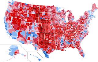
English: Results by county of the United States presidential election, 2016.
Clinton—80-90%
Clinton—70-80%
Clinton—60-70%
Clinton—50-60%
Clinton—40-50%
Clinton—<40%
Trump—<40%
Trump—40-50%
Trump—50-60%
Trump—60-70%
Trump—70-80%
Trump—80-90%
Trump—>90%
|
||||
| 날짜 | |||||
| 출처 |
이 파일은 다음에 의해 파생됨: USA Counties.svg |
||||
| 저자 | Ali Zifan 와 Inqvisitor | ||||
| 저작권 (이 파일을 인용하기) |
|
||||
| 다른 버전 |
[]
|


.svg)
.svg)


파일 역사
날짜/시간 링크를 클릭하면 해당 시간의 파일을 볼 수 있습니다.
| 날짜/시간 | 섬네일 | 크기 | 사용자 | 설명 | |
|---|---|---|---|---|---|
| 현재 | 2023년 3월 4일 (토) 08:04 | | 555 × 352 (1.74 MB) | Gordfather69 | line width |
| 2019년 12월 1일 (일) 14:37 |  | 555 × 352 (1.73 MB) | SpeedMcCool | Fixed Tazewell County, Illinois | |
| 2019년 11월 22일 (금) 01:06 |  | 555 × 352 (1.73 MB) | SpeedMcCool | Updated McCone County Montana | |
| 2019년 10월 11일 (금) 10:13 |  | 555 × 352 (1.73 MB) | SpeedMcCool | Fixed Potter and Lehigh Counties PA | |
| 2018년 10월 28일 (일) 06:50 |  | 555 × 352 (1.73 MB) | Vartemp | Fixed shading for McDonald County, MO. | |
| 2017년 7월 30일 (일) 01:16 |  | 555 × 352 (1.73 MB) | Inqvisitor | Two county shading corrections | |
| 2017년 2월 16일 (목) 01:41 |  | 555 × 352 (1.74 MB) | Jayjay8990 | Reverted to version as of 05:49, 8 February 2017 (UTC) | |
| 2017년 2월 15일 (수) 10:50 |  | 990 × 627 (983 KB) | Kingofthedead | Reverted to version as of 05:41, 8 February 2017 (UTC) I disagree that the borders are too thin, and this map is much larger and clearer | |
| 2017년 2월 8일 (수) 14:49 |  | 555 × 352 (1.74 MB) | TL565 | Don't you falsely accuse me of sock puppetry! The map should match the previous county maps and yes the borders are way too thin. | |
| 2017년 2월 8일 (수) 14:41 |  | 990 × 627 (983 KB) | Oganesson007 | @TL565 Please stop reverting the map with the alternative accounts. Also, This map is half of the size of that with optimal border size and more clarification. In this map (unlike the map that you keep putting here) small counties are clearly visible. |
이 파일을 사용하는 문서
이 파일을 사용하는 문서가 없습니다.
이 파일을 사용하고 있는 모든 위키의 문서 목록
다음 위키에서 이 파일을 사용하고 있습니다:
- ar.wikipedia.org에서 이 파일을 사용하고 있는 문서 목록
- bg.wikipedia.org에서 이 파일을 사용하고 있는 문서 목록
- ca.wikipedia.org에서 이 파일을 사용하고 있는 문서 목록
- cs.wikipedia.org에서 이 파일을 사용하고 있는 문서 목록
- de.wikipedia.org에서 이 파일을 사용하고 있는 문서 목록
- en.wikipedia.org에서 이 파일을 사용하고 있는 문서 목록
- fa.wikipedia.org에서 이 파일을 사용하고 있는 문서 목록
- fr.wikipedia.org에서 이 파일을 사용하고 있는 문서 목록
- hu.wikipedia.org에서 이 파일을 사용하고 있는 문서 목록
- nl.wikipedia.org에서 이 파일을 사용하고 있는 문서 목록
- no.wikipedia.org에서 이 파일을 사용하고 있는 문서 목록
- pa.wikipedia.org에서 이 파일을 사용하고 있는 문서 목록
- zh.wikipedia.org에서 이 파일을 사용하고 있는 문서 목록