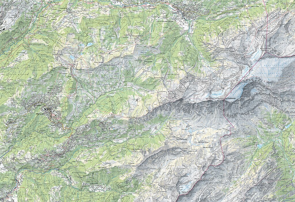
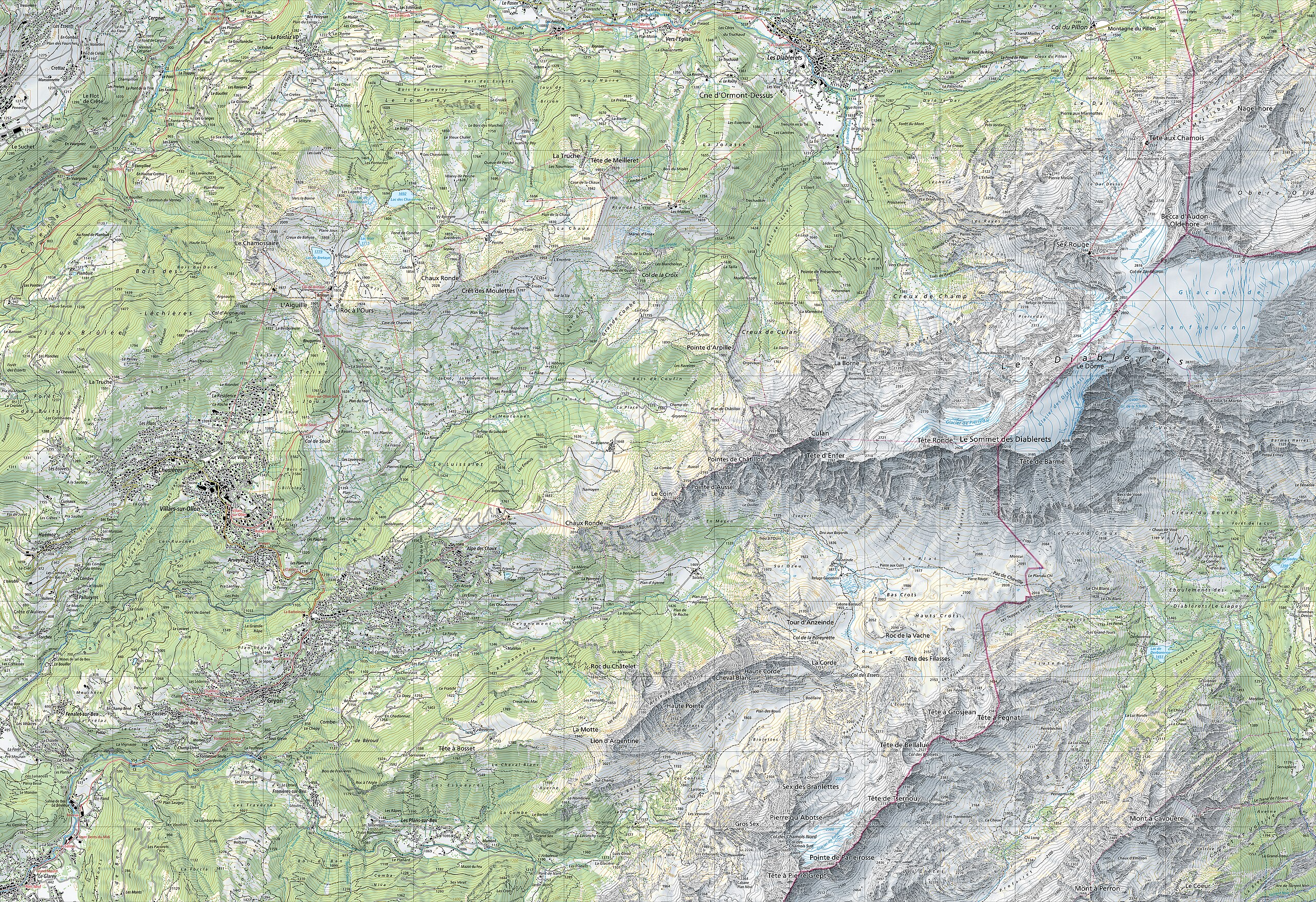
파일:1285 Les Diablerets.jpg

미리 보기 크기: 800 × 549 픽셀 다른 해상도: 320 × 219 픽셀 | 640 × 439 픽셀 | 1,024 × 702 픽셀 | 1,280 × 878 픽셀 | 2,560 × 1,755 픽셀 | 14,000 × 9,600 픽셀
원본 파일 (14,000 × 9,600 픽셀, 파일 크기: 128.79 MB, MIME 종류: image/jpeg)
파일 설명
| 주의 | 이 그림은 크기가 상당히 크며, 일부 브라우저의 경우 그림을 실제 크기로 표시할 때 프로그램이 멈출 수 있습니다. 이 경우, '최대 해상도' 링크 위에서 마우스 오른쪽 버튼을 눌러서 컴퓨터 파일로 저장한 다음, 포토샵이나 GIMP 같은 편집기를 이용해서 파일을 열어 주세요. |
|---|
| 제목 |
Les Diablerets |
|||||||||||||||||||||||
| 부제 | Villars-sur-Ollon - Gryon - Col du Pillon | |||||||||||||||||||||||
| 묘사 |
Deutsch: Blatt 1285 Les Diablerets der Landeskarte der Schweiz 1:25'000.
Français : Feuille 1285 Les Diablerets de la Carte nationale de la Suisse 1:25 000.
English: National Map of Switzerland 1:25'000, sheet 1285 Les Diablerets. Nota bene: this is compressed JPEG version of the original TIFF file. The map can be also consulted on the geographical portal. |
|||||||||||||||||||||||
| 지도 범례 |
English: For explanatory notes and symbols, see Conventional signs, pp. 2–4, 12 (2023), displayed below. Lines of the Swiss grid on the 1:25'000 have a spacing of 1 km. An entire sheet covers an area of 17.5 km x 12 km: 210 square kilometres (81 sq mi).
|
|||||||||||||||||||||||
| Adjacent sheets |
|
|||||||||||||||||||||||
| Sheet index | ||||||||||||||||||||||||
| 날짜 | ||||||||||||||||||||||||
| 출처 |
|
|||||||||||||||||||||||
| 창작자 |
|
|||||||||||||||||||||||
| 지리 정보 | ||||||||||||||||||||||||
| 지도 위치 | Les Diablerets | |||||||||||||||||||||||
| 사용된 공간기준계 | Swiss coordinate system | |||||||||||||||||||||||
| 축척 | 1:25,000 | |||||||||||||||||||||||
| 표제 |
 |
|||||||||||||||||||||||
| 지리 참고 | 부적절한 경우에 숨기려면 warp_status = skip로 설정하세요. | |||||||||||||||||||||||
| Swiss grid |
|
|||||||||||||||||||||||
| 서적 정보 | ||||||||||||||||||||||||
| 시리즈 | National Map of Switzerland 1:25'000 | |||||||||||||||||||||||
| 지도 양식 | 1285 | |||||||||||||||||||||||
| Print edition | ISBN: 978-3-302-01285-8 | |||||||||||||||||||||||


| 대상 위치 | | 이 지역의 다른 사진을 보기: OpenStreetMap |
|---|
라이선스
The data made publicly available by swisstopo may be used, distributed and made accessible. Furthermore, they may be enriched and processed and also used commercially. A reference to the source is mandatory. In the case of digital or analogue representations and publications, as well as in the case of dissemination, one of the following source references must be attached in any case:
Terms of use for free geodata and geoservices (OGD) from swisstopo
|
.svg) |
파일 역사
날짜/시간 링크를 클릭하면 해당 시간의 파일을 볼 수 있습니다.
| 날짜/시간 | 섬네일 | 크기 | 사용자 | 설명 | |
|---|---|---|---|---|---|
| 현재 | 2023년 9월 13일 (수) 05:52 | | 14,000 × 9,600 (128.79 MB) | Yann | c:User:Rillke/bigChunkedUpload.js: less compression |
| 2021년 3월 20일 (토) 19:33 |  | 14,000 × 9,600 (24.68 MB) | Zacharie Grossen | Uploaded a work by Bundesamt für Landestopografie swisstopo from [https://www.swisstopo.admin.ch/en/geodata/maps/smr/smr25.html swisstopo] with UploadWizard |
이 파일을 사용하는 문서
다음 문서 1개가 이 파일을 사용하고 있습니다:
이 파일을 사용하고 있는 모든 위키의 문서 목록
다음 위키에서 이 파일을 사용하고 있습니다:
- de.wikipedia.org에서 이 파일을 사용하고 있는 문서 목록
- en.wikipedia.org에서 이 파일을 사용하고 있는 문서 목록