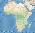
파일:Africa land cover location map.jpg

미리 보기 크기: 635 × 600 픽셀 다른 해상도: 254 × 240 픽셀 | 508 × 480 픽셀 | 813 × 768 픽셀 | 1,084 × 1,024 픽셀 | 1,525 × 1,440 픽셀
원본 파일 (1,525 × 1,440 픽셀, 파일 크기: 523 KB, MIME 종류: image/jpeg)
파일 역사
날짜/시간 링크를 클릭하면 해당 시간의 파일을 볼 수 있습니다.
| 날짜/시간 | 섬네일 | 크기 | 사용자 | 설명 | |
|---|---|---|---|---|---|
| 현재 | 2011년 7월 15일 (금) 03:54 |  | 1,525 × 1,440 (523 KB) | Sting | Sudan/South Sudan 07-2011 border update |
| 2010년 7월 19일 (월) 22:33 |  | 1,525 × 1,440 (440 KB) | Sting | Color profile | |
| 2010년 7월 7일 (수) 11:55 |  | 1,525 × 1,440 (447 KB) | Sting | Again... | |
| 2010년 7월 7일 (수) 11:49 |  | 1,525 × 1,440 (441 KB) | Sting | Public domain => no copyright mention | |
| 2010년 7월 4일 (일) 05:29 |  | 1,525 × 1,440 (447 KB) | Sting | == {{int:filedesc}} == {{Location|00|00|00|N|15|00|00|E|scale:30000000}} <br/>{{Information |Description={{en|Land cover map of Africa simulating the natural aspect of the land with bathymetry; for geo-location purposes.} |
이 파일을 사용하는 문서
이 파일을 사용하는 문서가 없습니다.
이 파일을 사용하고 있는 모든 위키의 문서 목록
다음 위키에서 이 파일을 사용하고 있습니다:
- als.wikipedia.org에서 이 파일을 사용하고 있는 문서 목록
- ar.wikipedia.org에서 이 파일을 사용하고 있는 문서 목록
- az.wikipedia.org에서 이 파일을 사용하고 있는 문서 목록
- ce.wikipedia.org에서 이 파일을 사용하고 있는 문서 목록
- de.wikipedia.org에서 이 파일을 사용하고 있는 문서 목록
- en.wikipedia.org에서 이 파일을 사용하고 있는 문서 목록
- frr.wikipedia.org에서 이 파일을 사용하고 있는 문서 목록
- fr.wikipedia.org에서 이 파일을 사용하고 있는 문서 목록
- hr.wikipedia.org에서 이 파일을 사용하고 있는 문서 목록
- Predložak:Klikabilna mapa start
- Predložak:Etnička karta/BiH/Fojnica
- Predložak:Etnička karta/BiH/Prozor-Rama
- Predložak:Etnička karta/BiH/Uskoplje
- Suradnik:Sombrero/sandbox
- Predložak:Etnička karta/BiH/Konjic
- Predložak:Etnička karta/BiH/Jablanica
- Predložak:Etnička karta/BiH/Kreševo
- Predložak:Etnička karta/BiH/Kupres
- Predložak:Etnička karta/BiH/Bugojno
- Predložak:Etnička karta/BiH/Brčko
- Modul:Location map
- Predložak:Location map
- Modul:Location map/data/Afrika
- Modul:Location map/doc
- Predložak:Location map/doc
- Modul:Location map/data/Afrika/doc
- inh.wikipedia.org에서 이 파일을 사용하고 있는 문서 목록
- lv.wikipedia.org에서 이 파일을 사용하고 있는 문서 목록
- myv.wikipedia.org에서 이 파일을 사용하고 있는 문서 목록
- pt.wikipedia.org에서 이 파일을 사용하고 있는 문서 목록
- ru.wikipedia.org에서 이 파일을 사용하고 있는 문서 목록
- si.wikipedia.org에서 이 파일을 사용하고 있는 문서 목록
- uz.wikipedia.org에서 이 파일을 사용하고 있는 문서 목록
이 파일의 더 많은 사용 내역을 봅니다.


