파일:Blair County Courthouse Apr 10.JPG

미리 보기 크기: 800 × 600 픽셀 다른 해상도: 320 × 240 픽셀 | 640 × 480 픽셀 | 1,024 × 768 픽셀 | 1,280 × 960 픽셀 | 2,592 × 1,944 픽셀
원본 파일 (2,592 × 1,944 픽셀, 파일 크기: 655 KB, MIME 종류: image/jpeg)
|
This is an image of a place or building that is listed on the National Register of Historic Places in the United States of America. Its reference number is 76001606. |
| 대상 위치 | | 이 지역의 다른 사진을 보기: OpenStreetMap |
|---|
| 설명 |
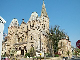
English: Blair County Courthouse, April 2010 |
||
| 날짜 | (UTC) | ||
| 출처 | 자작 (Original text: I (Pubdog (talk)) created this work entirely by myself.) | ||
| 저자 | Pubdog (talk) | ||
| 저작권 (이 파일을 인용하기) |
|
기존 올리기 기록
The original description page was here. All following user names refer to en.wikipedia.
- 2010-04-11 19:11 Pubdog 2592×1944 (765572 bytes) {{Information |Description = Blair County Courthouse, April 2010 |Source = I (~~~) created this work entirely by myself. |Date = ~~~~~ |Author = ~~~ |other_versions = }}
- 2010-04-11 19:13 Pubdog 2592×1944 (670670 bytes) straighten
파일 역사
날짜/시간 링크를 클릭하면 해당 시간의 파일을 볼 수 있습니다.
| 날짜/시간 | 섬네일 | 크기 | 사용자 | 설명 | |
|---|---|---|---|---|---|
| 현재 | 2011년 10월 15일 (토) 18:03 | | 2,592 × 1,944 (655 KB) | BotMultichill | {{BotMoveToCommons|en.wikipedia|year={{subst:CURRENTYEAR}}|month={{subst:CURRENTMONTHNAME}}|day={{subst:CURRENTDAY}}}} == {{int:filedesc}} == {{Information |description={{en|1=Blair County Courthouse, April 2010}} |date=19:11, 11 April 2010 (UTC) |source |
이 파일을 사용하는 문서
다음 문서 1개가 이 파일을 사용하고 있습니다:
이 파일을 사용하고 있는 모든 위키의 문서 목록
다음 위키에서 이 파일을 사용하고 있습니다:
- ar.wikipedia.org에서 이 파일을 사용하고 있는 문서 목록
- az.wikipedia.org에서 이 파일을 사용하고 있는 문서 목록
- ceb.wikipedia.org에서 이 파일을 사용하고 있는 문서 목록
- cy.wikipedia.org에서 이 파일을 사용하고 있는 문서 목록
- de.wikipedia.org에서 이 파일을 사용하고 있는 문서 목록
- en.wikipedia.org에서 이 파일을 사용하고 있는 문서 목록
- Blair County, Pennsylvania
- National Register of Historic Places listings in Blair County, Pennsylvania
- List of Pennsylvania state historical markers in Blair County
- Blair County Courthouse
- User talk:Dthomsen8/List PA Test
- User:Smallbones/PA Gallery
- List of state and county courthouses in Pennsylvania
- fa.wikipedia.org에서 이 파일을 사용하고 있는 문서 목록
- fr.wikipedia.org에서 이 파일을 사용하고 있는 문서 목록
- ga.wikipedia.org에서 이 파일을 사용하고 있는 문서 목록
- hu.wikipedia.org에서 이 파일을 사용하고 있는 문서 목록
- hy.wikipedia.org에서 이 파일을 사용하고 있는 문서 목록
- ja.wikipedia.org에서 이 파일을 사용하고 있는 문서 목록
- ml.wikipedia.org에서 이 파일을 사용하고 있는 문서 목록
- no.wikipedia.org에서 이 파일을 사용하고 있는 문서 목록
- pl.wikipedia.org에서 이 파일을 사용하고 있는 문서 목록
- pt.wikipedia.org에서 이 파일을 사용하고 있는 문서 목록
- ro.wikipedia.org에서 이 파일을 사용하고 있는 문서 목록
- ru.wikipedia.org에서 이 파일을 사용하고 있는 문서 목록
- sr.wikipedia.org에서 이 파일을 사용하고 있는 문서 목록
- sv.wikipedia.org에서 이 파일을 사용하고 있는 문서 목록
- tr.wikipedia.org에서 이 파일을 사용하고 있는 문서 목록
- tt.wikipedia.org에서 이 파일을 사용하고 있는 문서 목록
- ur.wikipedia.org에서 이 파일을 사용하고 있는 문서 목록
- www.wikidata.org에서 이 파일을 사용하고 있는 문서 목록
- zh-min-nan.wikipedia.org에서 이 파일을 사용하고 있는 문서 목록
- zh.wikipedia.org에서 이 파일을 사용하고 있는 문서 목록