파일:Cat Island, Bahamas.JPG

미리 보기 크기: 800 × 532 픽셀 다른 해상도: 320 × 213 픽셀 | 640 × 426 픽셀 | 1,024 × 681 픽셀 | 1,280 × 852 픽셀 | 2,560 × 1,703 픽셀 | 4,256 × 2,832 픽셀
원본 파일 (4,256 × 2,832 픽셀, 파일 크기: 6.61 MB, MIME 종류: image/jpeg)
파일 설명
| 설명 |
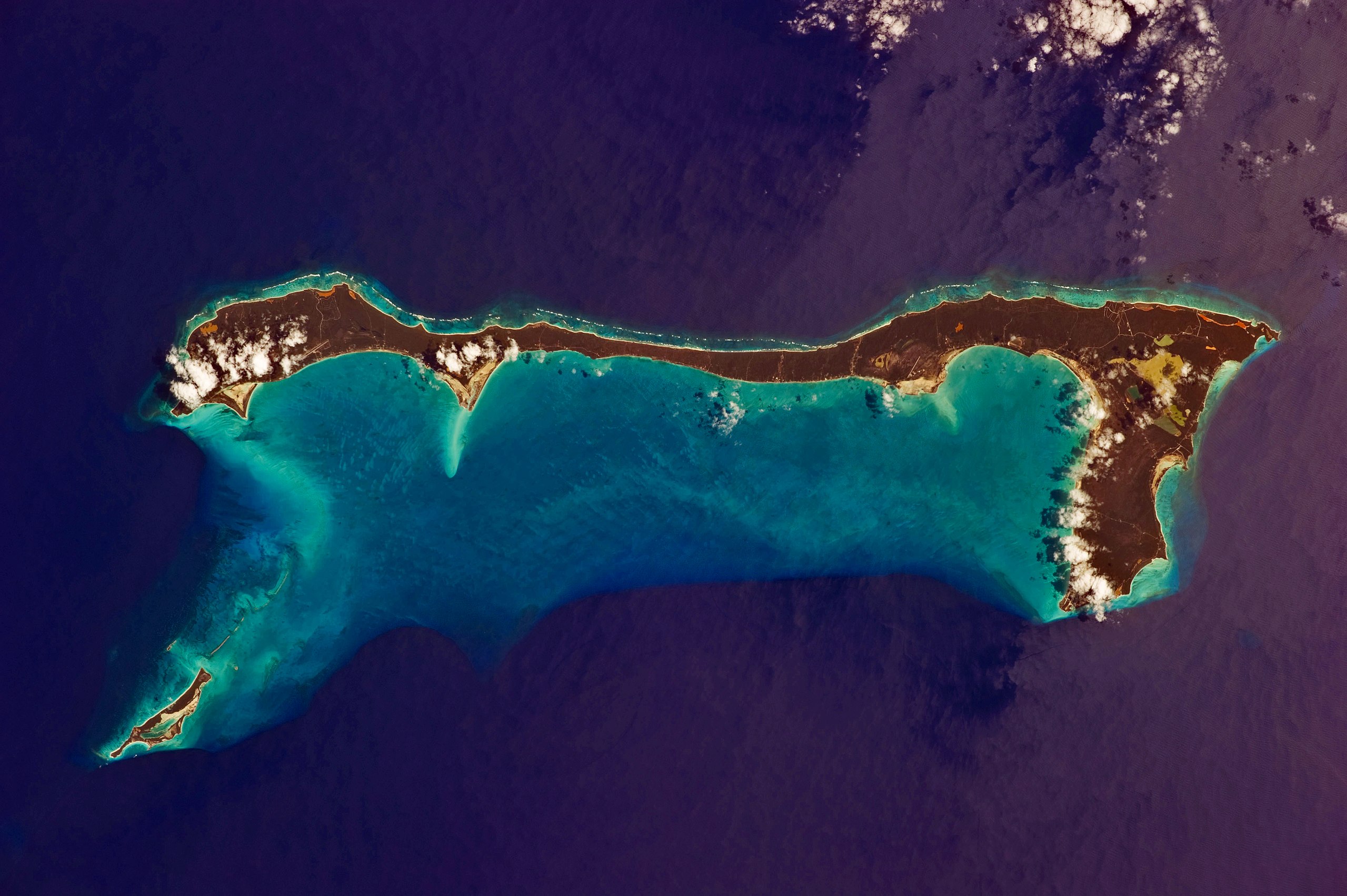
English: Like most other islands in the Bahamas, Cat Island is located on a large depositional platform that is composed mainly of carbonate sediments and surrounding reefs. The approximately 77 kilometre-long island is the part of the platform continuously exposed above water, which allows for soil development (brown to tan areas) and the growth of vegetation.
Shallow water to the west-south-west (below the island in this view) appears bright blue, in contrast to the deeper ocean waters to the north, east, and south. In this astronaut photograph, the ocean surface near the south-eastern half of the island has a slight grey tinge due to sun-glint, or light reflecting off the water surface back towards the International Space Station. Small white cumulus clouds obscure some parts of the island. |
| 날짜 | |
| 출처 | NASA Earth Observatory |
| 저자 | ISS Expedition 26 crew |
| 카메라 위치 | | 이 지역의 다른 사진을 보기: OpenStreetMap |
|---|
This image or video was catalogued by Johnson Space Center of the United States National Aeronautics and Space Administration (NASA) under Photo ID: ISS026-E-33193. This tag does not indicate the copyright status of the attached work. A normal copyright tag is still required. See Commons:Licensing. Other languages:
|
Image acquired with a Nikon D3S digital camera using an effective 135 mm lens, and is provided by the ISS Crew Earth Observations experiment and Image Science & Analysis Laboratory, Johnson Space Center.
라이선스
| 이 파일은 NASA에서 제작하였으므로 퍼블릭 도메인입니다. NASA의 저작권 정책에 따르면 NASA의 자료는 명시하지 않는 이상 저작권의 보호를 받지 않습니다. (Template:PD-USGov, 또는 NASA 저작권 정책 문서, JPL 그림 사용 정책을 참고하세요.) | ||
 |
주의사항:
|
| 주석 | 이 이미지에는 주석이 있습니다: 공용에서 주석을 보기 |
파일 역사
날짜/시간 링크를 클릭하면 해당 시간의 파일을 볼 수 있습니다.
| 날짜/시간 | 섬네일 | 크기 | 사용자 | 설명 | |
|---|---|---|---|---|---|
| 현재 | 2011년 3월 21일 (월) 19:37 | | 4,256 × 2,832 (6.61 MB) | Originalwana | {{Information |Description ={{en|1=Like most other islands in the Bahamas, Cat Island is located on a large depositional platform that is composed mainly of carbonate sediments and surrounding reefs. The approximately 77 kilometre-long island is the pa |
이 파일을 사용하는 문서
다음 문서 1개가 이 파일을 사용하고 있습니다:
이 파일을 사용하고 있는 모든 위키의 문서 목록
다음 위키에서 이 파일을 사용하고 있습니다:
- ar.wikipedia.org에서 이 파일을 사용하고 있는 문서 목록
- arz.wikipedia.org에서 이 파일을 사용하고 있는 문서 목록
- az.wikipedia.org에서 이 파일을 사용하고 있는 문서 목록
- ca.wikipedia.org에서 이 파일을 사용하고 있는 문서 목록
- ceb.wikipedia.org에서 이 파일을 사용하고 있는 문서 목록
- cs.wikipedia.org에서 이 파일을 사용하고 있는 문서 목록
- de.wikipedia.org에서 이 파일을 사용하고 있는 문서 목록
- de.wikivoyage.org에서 이 파일을 사용하고 있는 문서 목록
- el.wikipedia.org에서 이 파일을 사용하고 있는 문서 목록
- en.wikipedia.org에서 이 파일을 사용하고 있는 문서 목록
- es.wikipedia.org에서 이 파일을 사용하고 있는 문서 목록
- fi.wikipedia.org에서 이 파일을 사용하고 있는 문서 목록
- fr.wikipedia.org에서 이 파일을 사용하고 있는 문서 목록
- he.wikipedia.org에서 이 파일을 사용하고 있는 문서 목록
- it.wikipedia.org에서 이 파일을 사용하고 있는 문서 목록
- lt.wikipedia.org에서 이 파일을 사용하고 있는 문서 목록
- nl.wikipedia.org에서 이 파일을 사용하고 있는 문서 목록
- no.wikipedia.org에서 이 파일을 사용하고 있는 문서 목록
- pl.wikipedia.org에서 이 파일을 사용하고 있는 문서 목록
- pt.wikipedia.org에서 이 파일을 사용하고 있는 문서 목록
- ro.wikipedia.org에서 이 파일을 사용하고 있는 문서 목록
- www.wikidata.org에서 이 파일을 사용하고 있는 문서 목록
- zh.wikipedia.org에서 이 파일을 사용하고 있는 문서 목록