파일:Charles Lyell - Pillars of Pozzuoli.jpg
미리 보기 크기: 386 × 599 픽셀 다른 해상도: 155 × 240 픽셀 | 309 × 480 픽셀 | 712 × 1,104 픽셀
원본 파일 (712 × 1,104 픽셀, 파일 크기: 197 KB, MIME 종류: image/jpeg)
파일 설명
| 카메라 위치 | | 이 지역의 다른 사진을 보기: OpenStreetMap |
|---|
| 설명 |
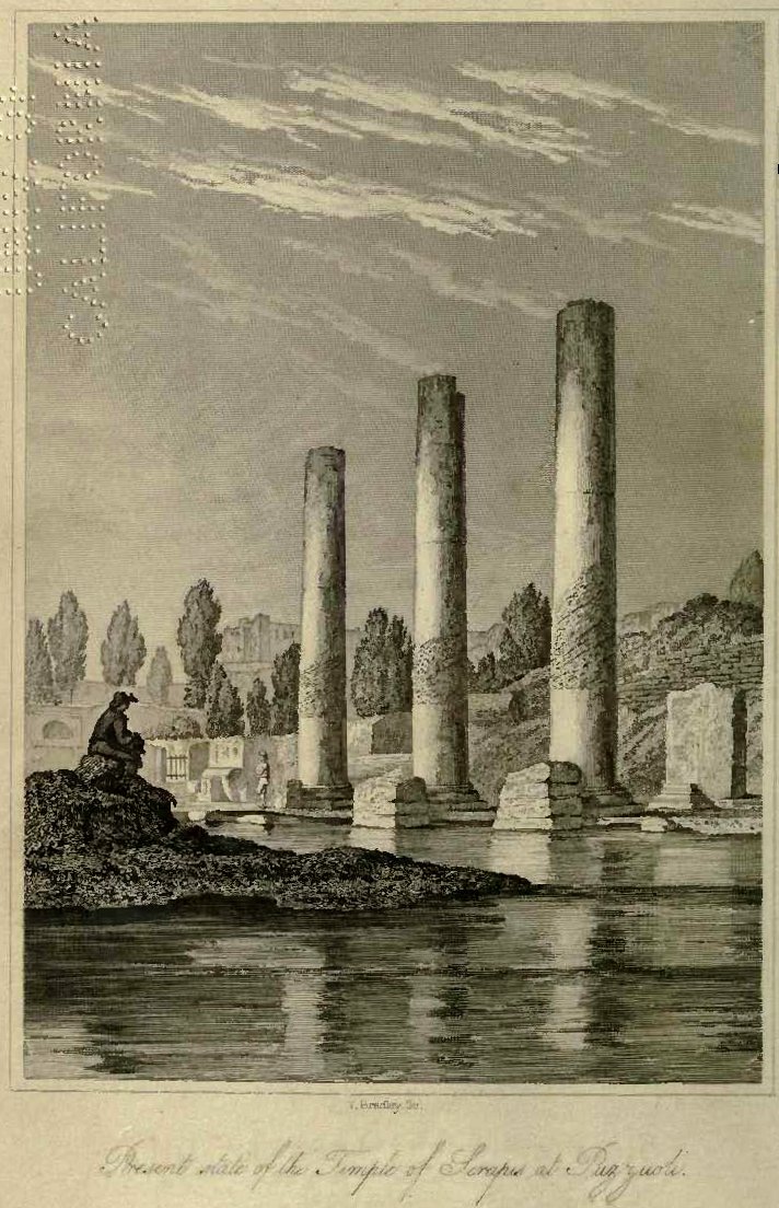
English: Pillars of the temple at Pozzuoli (Italy) used by Lyell to show former sea level differing from today. The corroded part at each pillar has once been below sea level. This higher sea level obviously is after the temple was built and was caused by downwarp and uplift of the land surface as a result of volcanic activity. |
| 날짜 | |
| 출처 | Charles Lyell, 1832. Principles of Geology, Vol.1; frontispice |
| 저자 | Charles Lyell |
라이선스
|
이 작품은 미국, 그리고 저작권 보호 기간이 저작자 사후 70년, 또는 그 이하인 모든 국가에서 퍼블릭 도메인입니다.
| |
| 이 저작물은 모든 저작인접권을 포함한 저작권법하의 규제로부터 자유로운 것으로 확인되었습니다. | |
파일 역사
날짜/시간 링크를 클릭하면 해당 시간의 파일을 볼 수 있습니다.
| 날짜/시간 | 섬네일 | 크기 | 사용자 | 설명 | |
|---|---|---|---|---|---|
| 현재 | 2011년 7월 17일 (일) 10:58 | | 712 × 1,104 (197 KB) | Materialscientist | rotate, crop, contrast |
| 2009년 10월 6일 (화) 04:03 |  | 726 × 1,241 (122 KB) | Tom Meijer | {{Information |Description={{en|1=Pillars of the temple at Pozzuoli (Italy) used by Lyell to show former sea level differing from today. The corroded part at each pillar has once been below sea level. This higher sea level obviously is after the temple wa |
이 파일을 사용하는 문서
다음 문서 1개가 이 파일을 사용하고 있습니다:
이 파일을 사용하고 있는 모든 위키의 문서 목록
다음 위키에서 이 파일을 사용하고 있습니다:
- ar.wikipedia.org에서 이 파일을 사용하고 있는 문서 목록
- az.wikipedia.org에서 이 파일을 사용하고 있는 문서 목록
- ca.wikipedia.org에서 이 파일을 사용하고 있는 문서 목록
- cs.wikipedia.org에서 이 파일을 사용하고 있는 문서 목록
- en.wikipedia.org에서 이 파일을 사용하고 있는 문서 목록
- es.wikipedia.org에서 이 파일을 사용하고 있는 문서 목록
- he.wikipedia.org에서 이 파일을 사용하고 있는 문서 목록
- it.wikipedia.org에서 이 파일을 사용하고 있는 문서 목록
- nl.wikipedia.org에서 이 파일을 사용하고 있는 문서 목록
- pt.wikipedia.org에서 이 파일을 사용하고 있는 문서 목록
- ru.wikipedia.org에서 이 파일을 사용하고 있는 문서 목록
- sl.wikipedia.org에서 이 파일을 사용하고 있는 문서 목록
- uk.wikipedia.org에서 이 파일을 사용하고 있는 문서 목록
- vi.wikipedia.org에서 이 파일을 사용하고 있는 문서 목록
- www.wikidata.org에서 이 파일을 사용하고 있는 문서 목록