파일:France départementale.svg

원본 파일 (SVG 파일, 실제 크기 2,000 × 1,898 픽셀, 파일 크기: 1.87 MB)
파일 설명
| 설명 |
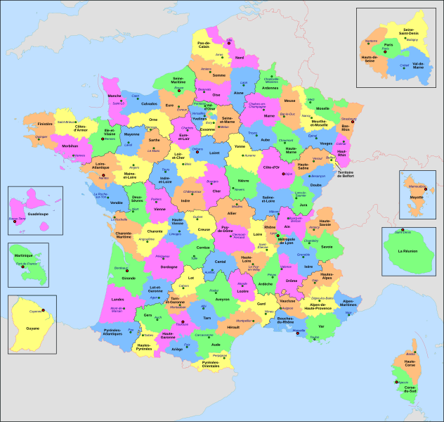
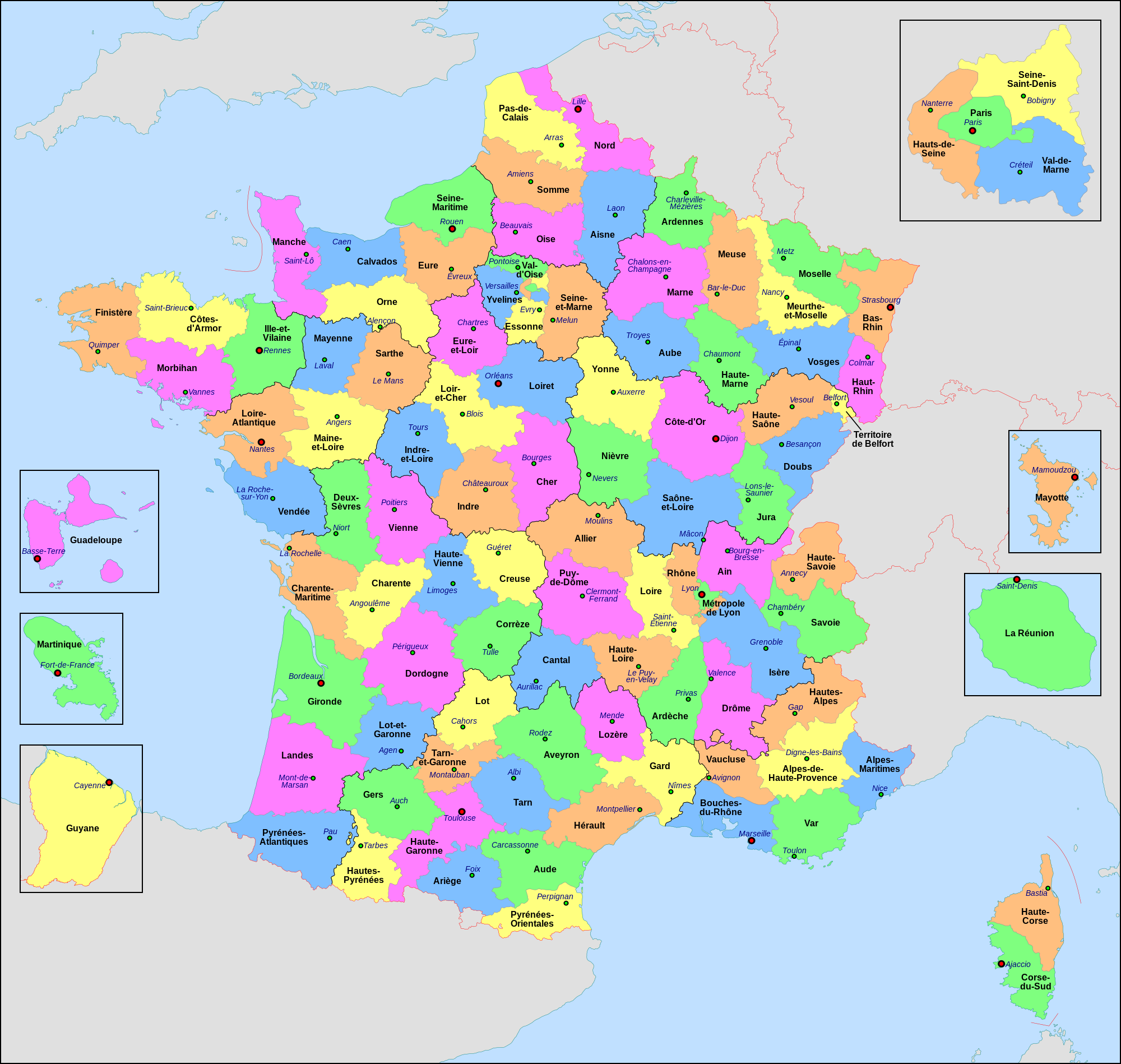
Français : Carte administrative de la France, créée sous Inkscape 0.47 à partir de plusieurs cartes (notamment celle-ci) créées par Sting.
Le fichier comporte vingt-quatre calques : Cadre, Chef-lieux de région, Villes, Chef-lieux de département, Numéros de département, Noms des régions, Nom des départements, **Encarts Départements d'Outre-Mer, **Encart Paris-Petite-Couronne, Coordonnées, Échelle et Mini-carte, Frontières internationales, Côtes, Limites régionales, Limites départementales, Lacs, Fleuves, *Régions métropolitaines, *Départements métropolitains, Terres françaises, Terres étrangères, Mers et océans, Échelle altimétrique, Topographie.
English: Administrative map of France, created under Inkscape 0.47 from several of the maps (especially this one) created by Sting.
The file consists of twenty-four layers: Frame, Administrative Centres of Regions, Towns, Administrative Centres of Departments, Numbers of Departments, Names of Regions, Names of Departments, **Overseas Departements Insets, **Paris Conurbation Inset, Coordinates, Scale and Mini-map, International boundaries, Coasts, Regional boundaries, Departmental boundaries, Lakes, Rivers, *Metropolitan Regions, *Metropolitan Departments, French lands, Foreign lands, Seas and Oceans, Altimetric Scale, Topography.
|
| 날짜 | |
| 출처 | 자작 |
| 저자 | Nilstilar |
| 다른 버전 |
|
| SVG 발전 |


라이선스
- 이용자는 다음의 권리를 갖습니다:
- 공유 및 이용 – 저작물의 복제, 배포, 전시, 공연 및 공중송신
- 재창작 – 저작물의 개작, 수정, 2차적저작물 창작
- 다음과 같은 조건을 따라야 합니다:
- 저작자표시 – 적절한 저작자 표시를 제공하고, 라이센스에 대한 링크를 제공하고, 변경사항이 있는지를 표시해야 합니다. 당신은 합리적인 방식으로 표시할 수 있지만, 어떤 방식으로든 사용권 허가자가 당신 또는 당신의 사용을 지지하는 방식으로 표시할 수 없습니다.
- 동일조건변경허락 – 만약 당신이 이 저작물을 리믹스 또는 변형하거나 이 저작물을 기반으로 제작하는 경우, 당신은 당신의 기여물을 원저작물과 동일하거나 호환 가능한 라이선스에 따라 배포하여야 합니다.
이 사진은 위키미디어 사용자의 사용자 페이지에서 사용되는 사진이며 공용의 정책에 따라 저장됩니다." 적은 수의 사진을 (예를 들어 당신의 얼굴) 공용 사용자 페이지에서 쓰려는 용도의 업로드는 허용됩니다. 또는 다른 프로젝트에서의 사용: 적은 수의 사진을 (예를 들어 당신의 얼굴) 다른 위키미디어 프로젝트 사용자 페이지에서 쓰려는 용도의 업로드는 허용됩니다.
만약 사진이 안 쓰이고, 교육적인 목적이 아니라면 삭제될 수 있습니다..
파일 역사
날짜/시간 링크를 클릭하면 해당 시간의 파일을 볼 수 있습니다.
| 날짜/시간 | 섬네일 | 크기 | 사용자 | 설명 | |
|---|---|---|---|---|---|
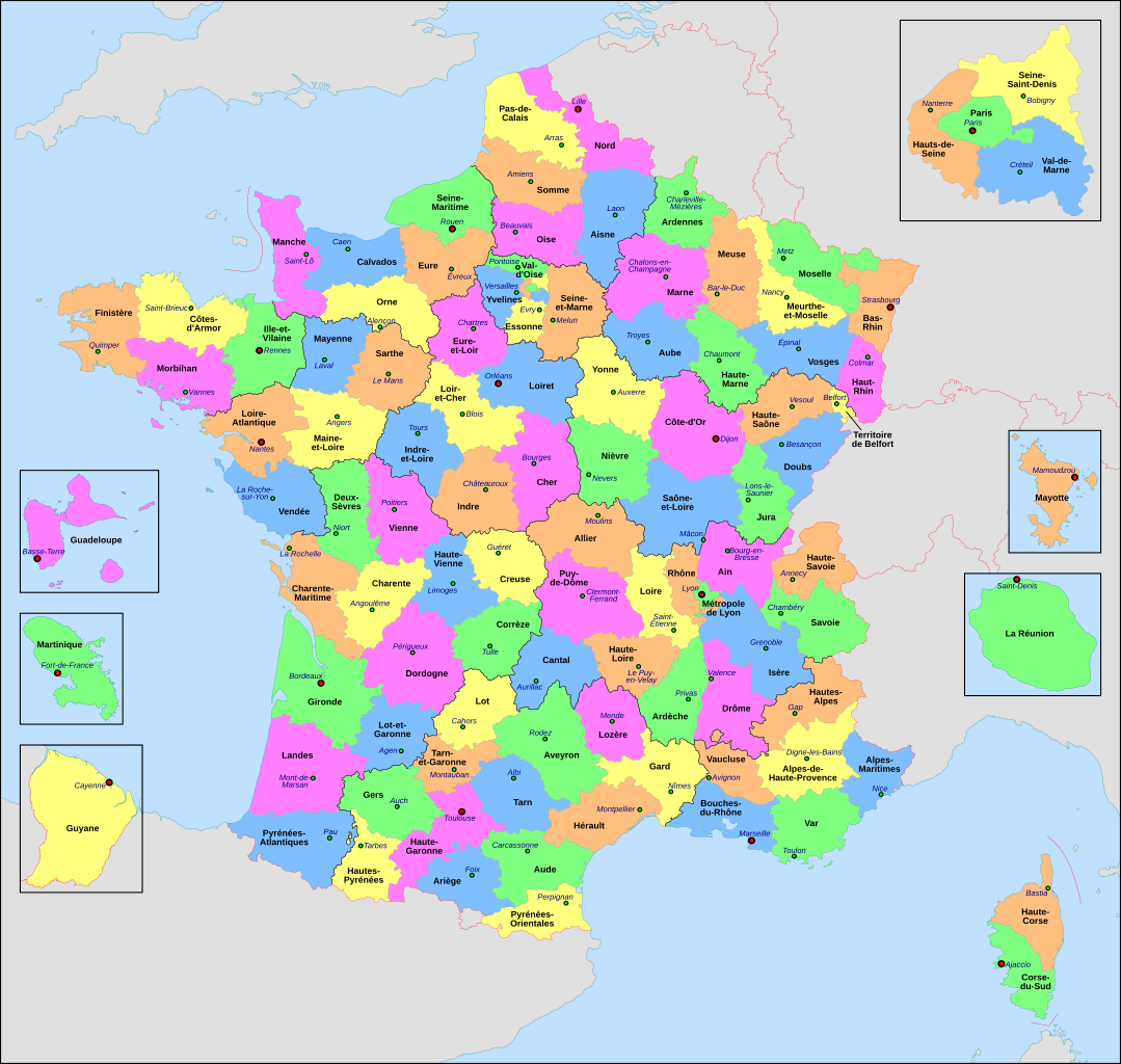
| 현재 | 2022년 6월 23일 (목) 05:29 | | 2,000 × 1,898 (1.87 MB) | OpesMentis | Added hyphens on departments' names and towns' names and fixed "Réunion" to "La Réunion" |
| 2021년 11월 10일 (수) 03:10 |  | 2,000 × 1,898 (1.87 MB) | Puck04 | fixed SVG code (was "W3C-invalid") + cleanup using text editor; contains some invisible pathes | |
| 2020년 5월 1일 (금) 09:40 |  | 2,000 × 1,898 (4.7 MB) | ChrisPtDe | File uploaded using svgtranslate tool (https://tools.wmflabs.org/svgtranslate/). Added translation for frp. | |
| 2020년 4월 29일 (수) 07:17 |  | 2,000 × 1,898 (4.7 MB) | ChrisPtDe | File uploaded using svgtranslate tool (https://tools.wmflabs.org/svgtranslate/). Added translation for frp. | |
| 2020년 4월 26일 (일) 07:56 |  | 2,000 × 1,898 (4.68 MB) | ChrisPtDe | File uploaded using svgtranslate tool (https://tools.wmflabs.org/svgtranslate/). Added translation for frp. | |
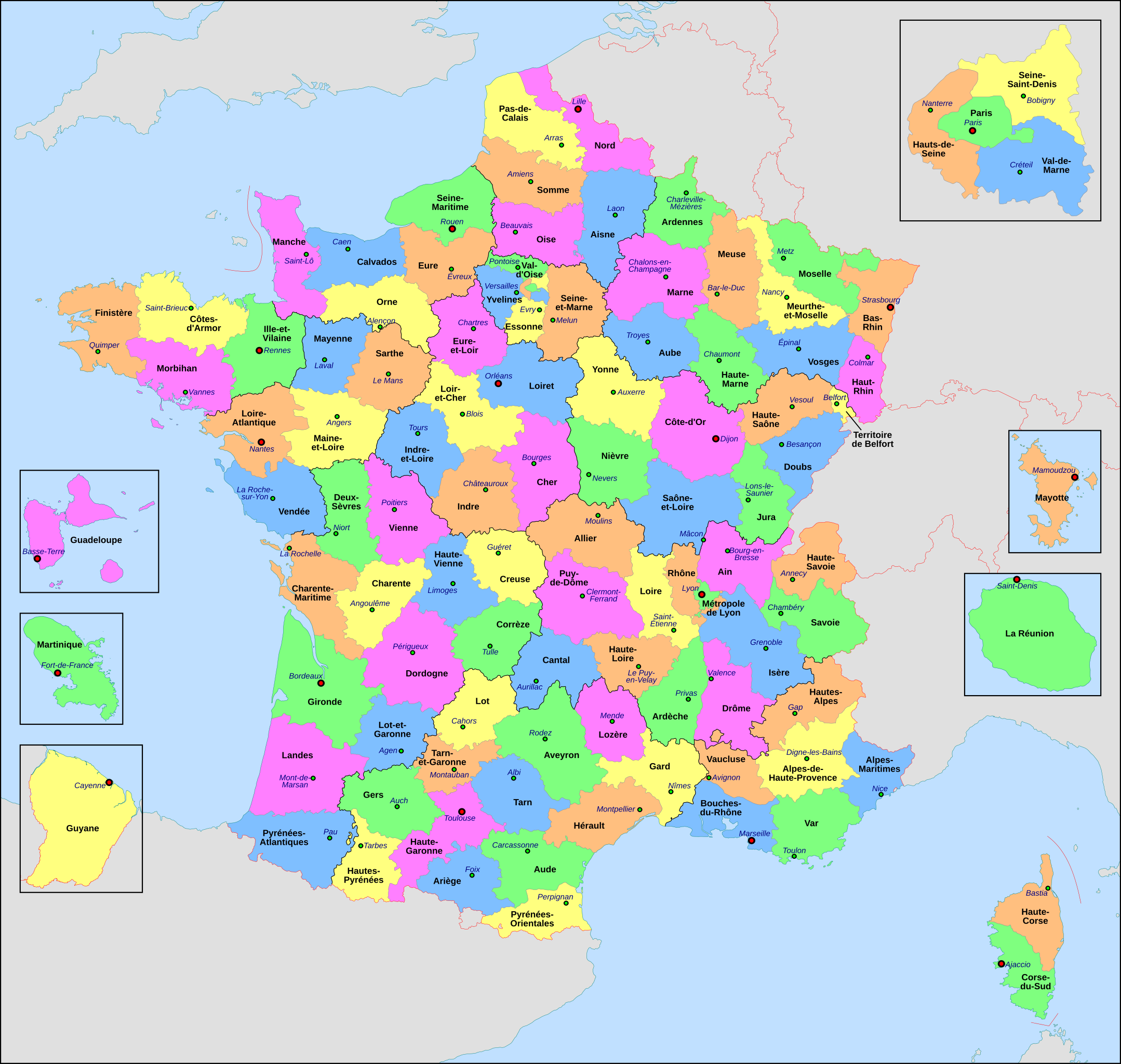
| 2018년 11월 4일 (일) 23:13 |  | 2,000 × 1,898 (4.55 MB) | Nilstilar | Corse "réunifiée" pose problème | |
| 2018년 11월 4일 (일) 21:05 |  | 2,000 × 1,898 (4.54 MB) | Nilstilar | Corse "réunifiée" (collectivité territoriale unique — département & région — au 1/1/2018) | |
| 2018년 10월 15일 (월) 22:01 |  | 2,000 × 1,898 (4.55 MB) | Nilstilar | Reverted to version as of 18:52, 10 May 2017 (UTC) | |
| 2017년 12월 29일 (금) 07:30 |  | 2,000 × 1,898 (2.24 MB) | Ras67 | frame removed, all invisible data stripped | |
| 2017년 5월 11일 (목) 03:52 |  | 2,000 × 1,898 (4.55 MB) | Nilstilar | Rétablissement des limites régionales (au 01/10/2016) |
이 파일을 사용하는 문서
다음 문서 1개가 이 파일을 사용하고 있습니다:
이 파일을 사용하고 있는 모든 위키의 문서 목록
다음 위키에서 이 파일을 사용하고 있습니다:
- ar.wikipedia.org에서 이 파일을 사용하고 있는 문서 목록
- arz.wikipedia.org에서 이 파일을 사용하고 있는 문서 목록
- ast.wikipedia.org에서 이 파일을 사용하고 있는 문서 목록
- ast.wiktionary.org에서 이 파일을 사용하고 있는 문서 목록
- az.wikipedia.org에서 이 파일을 사용하고 있는 문서 목록
- bg.wikipedia.org에서 이 파일을 사용하고 있는 문서 목록
- br.wikipedia.org에서 이 파일을 사용하고 있는 문서 목록
- ca.wikipedia.org에서 이 파일을 사용하고 있는 문서 목록
- cy.wikipedia.org에서 이 파일을 사용하고 있는 문서 목록
- el.wikipedia.org에서 이 파일을 사용하고 있는 문서 목록
- en.wikipedia.org에서 이 파일을 사용하고 있는 문서 목록
- es.wikipedia.org에서 이 파일을 사용하고 있는 문서 목록
- eu.wikipedia.org에서 이 파일을 사용하고 있는 문서 목록
- fr.wikipedia.org에서 이 파일을 사용하고 있는 문서 목록
- Département français
- Monument historique (France)
- Géographie de la Guadeloupe
- Économie de la Guadeloupe
- Transports en France
- Liste des ponts de Paris
- Géographie de la Drôme
- Liste des anciennes communes du Loiret
- Économie de La Réunion
- Politique dans la Haute-Vienne
- Politique dans la Creuse
- Climat des Yvelines
- Géographie du Territoire de Belfort
- Culture en Guyane
- Économie du Puy-de-Dôme
- Géographie de la Charente-Maritime
- Économie de l'Oise
- Économie de la Haute-Savoie
- Climat de l'Aveyron
- Climat du Bas-Rhin
- Climat du Haut-Rhin
- Géographie du Loiret
- Arboretum de Balaine
- Transports dans la métropole de Lyon
- Économie de la Haute-Saône
- Climat du Finistère
- Politique à La Réunion
- Géographie d'Eure-et-Loir
- Transport en Corse
- Liste des musées de Paris
이 파일의 더 많은 사용 내역을 봅니다.