파일:Gilman (United States (after the Treaty of Guadalupe Hidalgo)) 1848 UTA.jpg

미리 보기 크기: 800 × 340 픽셀 다른 해상도: 320 × 136 픽셀 | 640 × 272 픽셀 | 1,024 × 435 픽셀 | 1,280 × 544 픽셀 | 3,417 × 1,453 픽셀
원본 파일 (3,417 × 1,453 픽셀, 파일 크기: 7.6 MB, MIME 종류: image/jpeg)
파일 설명
| 제목 |
English: [United States (after the Treaty of Guadalupe Hidalgo)] |
||||||||||||||||||||||||||
| 묘사 |
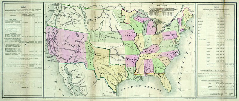
English: By the Treaty of Guadalupe Hidalgo at the end of the U.S. War with Mexico in 1848, the United States received the former Mexican territories of Upper California and New Mexico and confirmed its claim to Texas. This map from President Polk's printed review of the year shows new and old boundaries, noting when and by which treaties these were established. The southwestern boundary, stretching west from El Paso, would prove a difficult problem in the coming years, established as it was during the treaty negotiations between the U.S. and Mexican diplomats on the basis of different editions of a faulty map – the Disturnell map of Mexico of 1847. The table at left documents the total estimated square miles, acreage, and miles of coastline acquired as well as the previously existing statistics for the nation and its various territories. Ominously, the table at right explains the square mileage and acreage of both the free and slave states and territories, documenting a critical area of contention that would ultimately lead to civil war. |
||||||||||||||||||||||||||
| 날짜 | |||||||||||||||||||||||||||
| 출처 | UTA Libraries Cartographic Connections: 지도 / text | ||||||||||||||||||||||||||
| 창작자 |
E. Gilman |
||||||||||||||||||||||||||
| 크레디트 라인 |
English: UTA Libraries Special Collections |
||||||||||||||||||||||||||
| 지리 정보 | |||||||||||||||||||||||||||
| 지도 위치 | 미국 | ||||||||||||||||||||||||||
| 지리 참고 | 부적절한 경우에 숨기려면 warp_status = skip로 설정하세요. | ||||||||||||||||||||||||||
| 서적 정보 | |||||||||||||||||||||||||||
| 출판물 |
Message of the President for 1848 (30th Cong., 2nd Sess., House Ex. Doc. No. 1) |
||||||||||||||||||||||||||
| 저자 | |||||||||||||||||||||||||||
| 출판 장소 | 워싱턴 D.C. | ||||||||||||||||||||||||||
| 인쇄자 |
P.S. Duval, 필라델피아 |
||||||||||||||||||||||||||
| 보관 기록 자료 | |||||||||||||||||||||||||||
| Collection |
|
||||||||||||||||||||||||||
| 크기 | 높이: 36 cm; 너비: 85.5 cm | ||||||||||||||||||||||||||
| 기법 | colored lithograph | ||||||||||||||||||||||||||
| artwork-references | Wheat Mapping the Trans-Mississippi West, 3, no. 561 , pp. 50, 265 | ||||||||||||||||||||||||||

)_1848_UTA.jpg?uselang=ko)
라이선스

|
This file was provided to Wikimedia Commons by the University of Texas at Arlington Libraries as part of a cooperation project. The University of Texas at Arlington Libraries is part of the University of Texas at Arlington, a public research university located in Arlington, Texas.
|
이 작품은 1929년 1월 1일 이전에 출판하였으므로 미국에서 퍼블릭 도메인입니다.
퍼블릭 도메인 작품을 공용에 올리기 위해서는 미국과 작품의 제작 국가에서 저작권이 만료되어야 합니다. 미국에서 제작된 작품이 아닐 경우, 제작 국가에서의 저작권 상태를 나타내는 저작권 태그를 반드시 추가로 부착해야 합니다.
|
파일 역사
날짜/시간 링크를 클릭하면 해당 시간의 파일을 볼 수 있습니다.
| 날짜/시간 | 섬네일 | 크기 | 사용자 | 설명 | |
|---|---|---|---|---|---|
| 현재 | 2022년 3월 12일 (토) 02:43 | | 3,417 × 1,453 (7.6 MB) | Michael Barera | == {{int:filedesc}} == {{Map |title = {{en|'''''[United States (after the Treaty of Guadalupe Hidalgo)]'''''}} |description = {{en|By the Treaty of Guadalupe Hidalgo at the end of the U.S. War with Mexico in 1848, the United States received the former Mexican territories of Upper California and New Mexico and confirmed its claim to Texas. This map from President Polk's printed review of the year shows new and old boundaries, noting when and by which treaties these were est... |
이 파일을 사용하는 문서
다음 문서 1개가 이 파일을 사용하고 있습니다:
이 파일을 사용하고 있는 모든 위키의 문서 목록
다음 위키에서 이 파일을 사용하고 있습니다:
- en.wikipedia.org에서 이 파일을 사용하고 있는 문서 목록
- es.wikipedia.org에서 이 파일을 사용하고 있는 문서 목록
- hu.wikipedia.org에서 이 파일을 사용하고 있는 문서 목록
)_1848_UTA.jpg)