파일:Harpers Dump 1949.jpg

미리 보기 크기: 800 × 544 픽셀 다른 해상도: 320 × 218 픽셀 | 640 × 435 픽셀 | 1,024 × 696 픽셀
원본 파일 (1,024 × 696 픽셀, 파일 크기: 99 KB, MIME 종류: image/jpeg)
파일 설명
| 설명 |
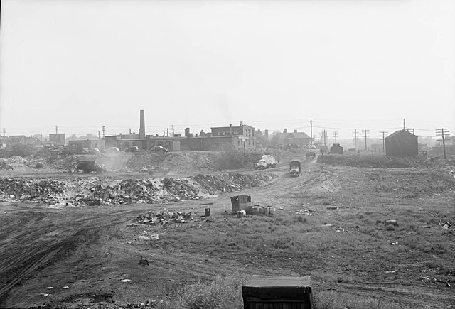
English: Harper's Dump, also known as the Greenwood Avenue Fill, was one of the main landfill sites in Toronto, Ontario, Canada. In the 1960s, it was replaced by the Greenwood TTC subway yard. |
||
| 날짜 | |||
| 출처 |
|
||
| 저자 | Howard McDonald |
| 카메라 위치 | | 이 지역의 다른 사진을 보기: OpenStreetMap |
|---|
라이선스
이 캐나다 저작물은 다음 조건 중 하나를 만족하기 때문에 퍼블릭 도메인입니다:
캐나다 정부 저작물이 아니며,
|
 |
이 파일은 크리에이티브 커먼즈 저작자표시 2.0 일반 라이선스로 배포됩니다.
- 이용자는 다음의 권리를 갖습니다:
- 공유 및 이용 – 저작물의 복제, 배포, 전시, 공연 및 공중송신
- 재창작 – 저작물의 개작, 수정, 2차적저작물 창작
- 다음과 같은 조건을 따라야 합니다:
- 저작자표시 – 적절한 저작자 표시를 제공하고, 라이센스에 대한 링크를 제공하고, 변경사항이 있는지를 표시해야 합니다. 당신은 합리적인 방식으로 표시할 수 있지만, 어떤 방식으로든 사용권 허가자가 당신 또는 당신의 사용을 지지하는 방식으로 표시할 수 없습니다.
| 플리커에 게시된 이 그림은 July 24, 2011에 관리자 혹은 신뢰된 사용자 File Upload Bot (Magnus Manske)에 의해 검토되어, 이 날짜를 기준으로 위의 라이선스로 사용 가능함이 확인되었습니다. |
파일 역사
날짜/시간 링크를 클릭하면 해당 시간의 파일을 볼 수 있습니다.
| 날짜/시간 | 섬네일 | 크기 | 사용자 | 설명 | |
|---|---|---|---|---|---|
| 현재 | 2011년 7월 26일 (화) 04:47 | | 1,024 × 696 (99 KB) | Ras67 | losslessly cropped with Jpegcrop |
| 2011년 7월 25일 (월) 06:37 |  | 1,050 × 765 (125 KB) | File Upload Bot (Magnus Manske) | {{Information |Description=Photographer: Howard McDonald June 30, 1949 [http://www.toronto.ca/archives/index.htm City of Toronto Archives] Series 372, Subseries 70, Item 586 |Source=[http://www.flickr.com/photos/torontohistory/4558892243/ Greenwood Avenue |
이 파일을 사용하는 문서
다음 문서 1개가 이 파일을 사용하고 있습니다:
이 파일을 사용하고 있는 모든 위키의 문서 목록
다음 위키에서 이 파일을 사용하고 있습니다:
- en.wikipedia.org에서 이 파일을 사용하고 있는 문서 목록