파일:Himalaya annotated.jpg

미리 보기 크기: 800 × 530 픽셀 다른 해상도: 320 × 212 픽셀 | 640 × 424 픽셀 | 1,000 × 662 픽셀
원본 파일 (1,000 × 662 픽셀, 파일 크기: 413 KB, MIME 종류: image/jpeg)
| 설명 |
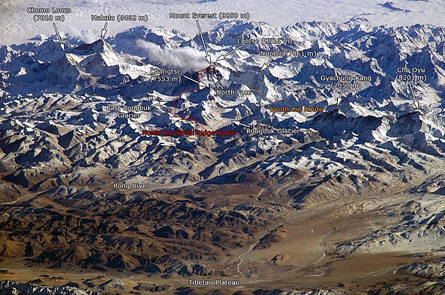
English: The Himalayan mountain range with Mount Everest as seen from the International Space Station looking south-south-east over the Tibetan Plateau. Four of the world's fourteen eight-thousanders, mountains higher than 8000 metres, can be seen, Makalu (8462 m), Everest (8850 m), Lhotse (8516 m) and Cho Oyu (8201 m). The South Col Route is Mount Everest's most often used climbing route. |
|||||
| 출처 |
This image is a modified version of this NASA Image. Annotations have been added by Janderk Jan Derk. If anyone finds errors please leave a note in the discussions area of this page. Original image: NASA |
|||||
| 저자 | NASA, Janderk Jan Derk | |||||
| 저작권 (이 파일을 인용하기) |
|
|||||
| 다른 버전 |
이 파일은 다음에 의해 파생됨: Himalayas.jpg |

파일 역사
날짜/시간 링크를 클릭하면 해당 시간의 파일을 볼 수 있습니다.
| 날짜/시간 | 섬네일 | 크기 | 사용자 | 설명 | |
|---|---|---|---|---|---|
| 현재 | 2006년 12월 7일 (목) 07:39 | | 1,000 × 662 (413 KB) | Janderk~commonswiki | Slight change in Nuptse location to try to make it point more to Nuptse I. |
| 2006년 12월 5일 (화) 21:08 |  | 1,000 × 662 (414 KB) | Janderk~commonswiki | Fixed errors. See talk page. | |
| 2005년 2월 20일 (일) 03:23 |  | 1,000 × 662 (416 KB) | RedWolf | Himalaya - annotated |
이 파일을 사용하는 문서
다음 문서 2개가 이 파일을 사용하고 있습니다:
이 파일을 사용하고 있는 모든 위키의 문서 목록
다음 위키에서 이 파일을 사용하고 있습니다:
- af.wikipedia.org에서 이 파일을 사용하고 있는 문서 목록
- anp.wikipedia.org에서 이 파일을 사용하고 있는 문서 목록
- ast.wikipedia.org에서 이 파일을 사용하고 있는 문서 목록
- awa.wikipedia.org에서 이 파일을 사용하고 있는 문서 목록
- azb.wikipedia.org에서 이 파일을 사용하고 있는 문서 목록
- az.wikipedia.org에서 이 파일을 사용하고 있는 문서 목록
- ba.wikipedia.org에서 이 파일을 사용하고 있는 문서 목록
- bcl.wikipedia.org에서 이 파일을 사용하고 있는 문서 목록
- beta.wikiversity.org에서 이 파일을 사용하고 있는 문서 목록
- be.wikipedia.org에서 이 파일을 사용하고 있는 문서 목록
- bg.wikipedia.org에서 이 파일을 사용하고 있는 문서 목록
- blk.wikipedia.org에서 이 파일을 사용하고 있는 문서 목록
- bn.wikipedia.org에서 이 파일을 사용하고 있는 문서 목록
- bs.wikipedia.org에서 이 파일을 사용하고 있는 문서 목록
- ca.wikipedia.org에서 이 파일을 사용하고 있는 문서 목록
- ckb.wikipedia.org에서 이 파일을 사용하고 있는 문서 목록
- csb.wikipedia.org에서 이 파일을 사용하고 있는 문서 목록
- cs.wikipedia.org에서 이 파일을 사용하고 있는 문서 목록
- da.wikipedia.org에서 이 파일을 사용하고 있는 문서 목록
- de.wikipedia.org에서 이 파일을 사용하고 있는 문서 목록
- el.wikipedia.org에서 이 파일을 사용하고 있는 문서 목록
- en.wikipedia.org에서 이 파일을 사용하고 있는 문서 목록
- eo.wikipedia.org에서 이 파일을 사용하고 있는 문서 목록
이 파일의 더 많은 사용 내역을 봅니다.