파일:Metro Brussels.svg

SVG 파일의 PNG 형식의 미리보기 크기: 800 × 531 픽셀. 다른 해상도: 320 × 212 픽셀 | 640 × 425 픽셀 | 1,024 × 680 픽셀 | 1,280 × 850 픽셀 | 2,560 × 1,699 픽셀 | 1,487 × 987 픽셀
원본 파일 (SVG 파일, 실제 크기 1,487 × 987 픽셀, 파일 크기: 1.01 MB)
파일 설명
| 설명 |
Deutsch: Karte des Brüsseler Metronetzes. Die sog. PREMETRO-Linien, die mit dünneren, blauen Linien dargestellt sind, sind unterirdische Straßenbahnstrecken, ähnlich der deutschen Stadtbahnnetze. Diese Strecken setzen sich an der Oberfläche über die hier gezeigten Abschnitte hinaus fort, was aber nicht abgebildet ist. Es existieren noch zwei weitere PREMETRO-Strecken, die allerdings nur jeweils eine Station haben, also habe ich aus Gründen der Übersichtlichkeit davon abgesehen, diese mit darzustellen. Stationen mit zwei Namen haben unterschiedliche Namen im Französischen bzw. Niederländischen. Stationen mit nur einem Namen besitzen keine Entsprechung in der jeweils anderen Sprache, bzw. beide Namen sind gleich.
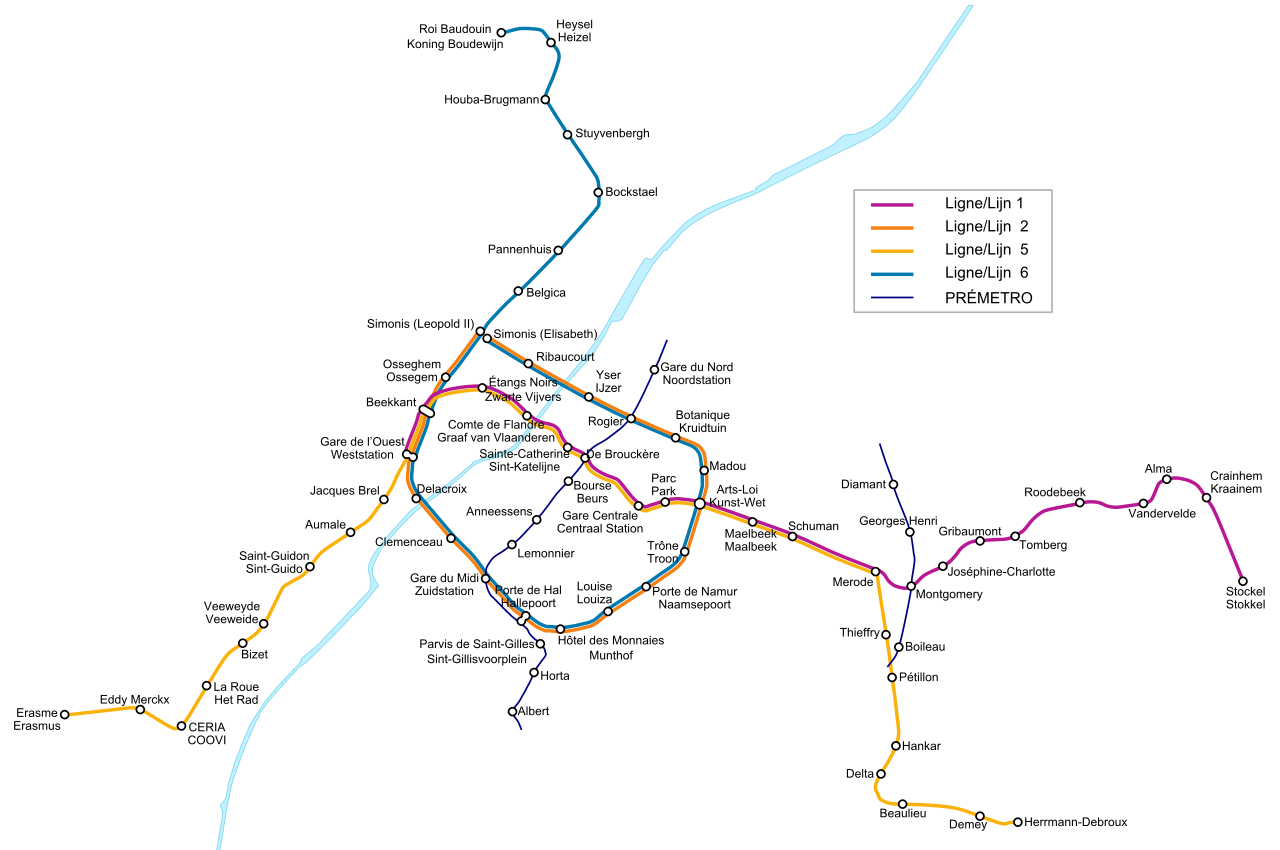
English: Map of the Metro Network of the Belgian capital Brussels. The so called PREMETRO sections, which are shown by blue, thinner lines, are underground sections of the tram network and continue further above ground, which is not shown on the map. There are two more PREMETRO-sections which cover only one station each, so I decided not to display them for a clearer view. Stations with two names have different names in the French and Dutch language. The French name is always shown above the Dutch one. Stations with only one name don't have an expression in the other language or both names are the same.
Français : Plan du réseau de métros de Bruxelles, Belgique. Les sections appelées PRÉMÉTRO, en lignes bleues fines, sont les parties souterraines du réseau de tramways. Elle se poursuivent en surface mais ne sont pas représentées sur la carte. Il y a également deux autres sections de PRÉMÉTRO mais, pour des raisons de clarté, j'ai choisi de ne pas les représenter. Les stations avec deux noms ont un nom différent en français et en néerlandais. Le nom français est toujours situé au dessus du nom néerlandais. Les stations avec un seul nom n'ont pas d'équivalent dans l'autre langue ou bien les deux noms sont identiques.
Nederlands: Kaart van het Brusselse metronet, hoofdstad van België. De zogenaamde PREMETRO-secties, in dunne, blauwe lijnen, zijn ondergrondse tramlijnen die verder lopen boven de grond, wat niet weergegeven wordt op de kaart. Er zijn tevens twee andere secties van de PREMETRO, die elk een station bedienen en niet getekend zijn om de kaart duidelijk te houden. Bij de stations waar de Franse naam verschilt van de Nederlandse, werd het Frans bovenaan geplaatst. |
| 출처 | 자작 |
| 저자 | L.m.k |
| 다른 버전 |
|


라이선스
나는 아래 작품의 저작권자로서, 이 저작물을 다음과 같은 라이선스로 배포합니다:

|
GNU 자유 문서 사용 허가서 1.2판 또는 자유 소프트웨어 재단에서 발행한 이후 판의 규정에 따라 본 문서를 복제하거나 개작 및 배포할 수 있습니다. 본 문서에는 변경 불가 부분이 없으며, 앞 표지 구절과 뒷 표지 구절도 없습니다. 본 사용 허가서의 전체 내용은 GNU 자유 문서 사용 허가서 부분에 포함되어 있습니다. |
| 이 파일은 크리에이티브 커먼즈 저작자표시-동일조건변경허락 3.0 Unported 라이선스로 배포됩니다. | ||
| ||
| 이 라이선스 틀은 GFDL 라이선스 변경의 일부로 이 파일에 추가되었습니다. |
- 이용자는 다음의 권리를 갖습니다:
- 공유 및 이용 – 저작물의 복제, 배포, 전시, 공연 및 공중송신
- 재창작 – 저작물의 개작, 수정, 2차적저작물 창작
- 다음과 같은 조건을 따라야 합니다:
- 저작자표시 – 적절한 저작자 표시를 제공하고, 라이센스에 대한 링크를 제공하고, 변경사항이 있는지를 표시해야 합니다. 당신은 합리적인 방식으로 표시할 수 있지만, 어떤 방식으로든 사용권 허가자가 당신 또는 당신의 사용을 지지하는 방식으로 표시할 수 없습니다.
- 동일조건변경허락 – 만약 당신이 이 저작물을 리믹스 또는 변형하거나 이 저작물을 기반으로 제작하는 경우, 당신은 당신의 기여물을 원저작물과 동일하거나 호환 가능한 라이선스에 따라 배포하여야 합니다.
이 라이선스 중에서 목적에 맞는 것을 선택하여 사용할 수 있습니다.
파일 역사
날짜/시간 링크를 클릭하면 해당 시간의 파일을 볼 수 있습니다.
| 날짜/시간 | 섬네일 | 크기 | 사용자 | 설명 | |
|---|---|---|---|---|---|
| 현재 | 2009년 5월 3일 (일) 06:34 | | 1,487 × 987 (1.01 MB) | M0tty | Correction orthographe + taille police |
| 2009년 5월 2일 (토) 07:34 |  | 1,457 × 992 (1.01 MB) | M0tty | corrections orthographiques | |
| 2009년 4월 25일 (토) 06:59 |  | 1,457 × 992 (1.01 MB) | M0tty | Change on new metro | |
| 2007년 9월 11일 (화) 17:51 |  | 1,457 × 992 (105 KB) | Poulpy | Gare Cantrale -> Gare Centrale | |
| 2006년 11월 18일 (토) 09:39 |  | 1,457 × 992 (105 KB) | L.m.k | Added new line section | |
| 2005년 11월 12일 (토) 09:50 |  | 1,457 × 992 (127 KB) | L.m.k | A station name wasn't aligned correctly. Now it is! | |
| 2005년 11월 12일 (토) 09:41 |  | 1,457 × 992 (127 KB) | L.m.k | {{en|Map of the Metro Network of the Belgian capital Brussels. The so called PREMETRO sections, which are shown by blue, thinner lines, are underground sections of the tram network and countinue further above ground, which is not shown on the map. There a |
이 파일을 사용하는 문서
이 파일을 사용하고 있는 모든 위키의 문서 목록
다음 위키에서 이 파일을 사용하고 있습니다:
- ar.wikipedia.org에서 이 파일을 사용하고 있는 문서 목록
- ba.wikipedia.org에서 이 파일을 사용하고 있는 문서 목록
- be-tarask.wikipedia.org에서 이 파일을 사용하고 있는 문서 목록
- bg.wikipedia.org에서 이 파일을 사용하고 있는 문서 목록
- bn.wikipedia.org에서 이 파일을 사용하고 있는 문서 목록
- ca.wikipedia.org에서 이 파일을 사용하고 있는 문서 목록
- cs.wikipedia.org에서 이 파일을 사용하고 있는 문서 목록
- cv.wikipedia.org에서 이 파일을 사용하고 있는 문서 목록
- da.wikipedia.org에서 이 파일을 사용하고 있는 문서 목록
- de.wikipedia.org에서 이 파일을 사용하고 있는 문서 목록
- el.wikipedia.org에서 이 파일을 사용하고 있는 문서 목록
- en.wikipedia.org에서 이 파일을 사용하고 있는 문서 목록
- eo.wikipedia.org에서 이 파일을 사용하고 있는 문서 목록
- es.wikipedia.org에서 이 파일을 사용하고 있는 문서 목록
- et.wikipedia.org에서 이 파일을 사용하고 있는 문서 목록
- eu.wikipedia.org에서 이 파일을 사용하고 있는 문서 목록
- fa.wikipedia.org에서 이 파일을 사용하고 있는 문서 목록
- fi.wikipedia.org에서 이 파일을 사용하고 있는 문서 목록
- fr.wikipedia.org에서 이 파일을 사용하고 있는 문서 목록
- Métro de Bruxelles
- Liste des stations du métro de Bruxelles
- Prémétro de Bruxelles
- Discussion utilisateur:TravauxSTIB
- Wikipédia:Atelier graphique/Images à améliorer/Archives/Avril 2009
- Wikipédia:Atelier graphique/Images à améliorer/Archives/Mai 2009
- Utilisateur:-Strogoff-/Archives 2009
- Utilisateur:Vascer/Brouillon2
- fr.wikivoyage.org에서 이 파일을 사용하고 있는 문서 목록
- fy.wikipedia.org에서 이 파일을 사용하고 있는 문서 목록
- hr.wikipedia.org에서 이 파일을 사용하고 있는 문서 목록
- hu.wikipedia.org에서 이 파일을 사용하고 있는 문서 목록
- hy.wikipedia.org에서 이 파일을 사용하고 있는 문서 목록
- it.wikipedia.org에서 이 파일을 사용하고 있는 문서 목록
- it.wikivoyage.org에서 이 파일을 사용하고 있는 문서 목록
- ka.wikipedia.org에서 이 파일을 사용하고 있는 문서 목록
- ku.wikipedia.org에서 이 파일을 사용하고 있는 문서 목록
- lb.wikipedia.org에서 이 파일을 사용하고 있는 문서 목록
이 파일의 더 많은 사용 내역을 봅니다.