파일:NASA Manhattan.jpg

미리 보기 크기: 253 × 599 픽셀 다른 해상도: 101 × 240 픽셀 | 604 × 1,431 픽셀
원본 파일 (604 × 1,431 픽셀, 파일 크기: 599 KB, MIME 종류: image/jpeg)
파일 설명
| 설명 |
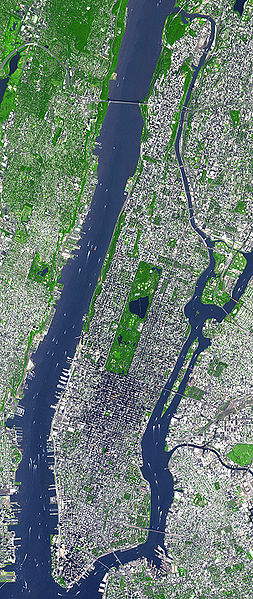
English: This false-color satellite image shows Manhattan, with Queens and Brookyn to the south east and New Jersey to the west. Central Park is visible in the center. This false-color image was acquired on Sept. 8, 2002, by the Advanced Spaceborne Thermal Emission and Reflection Radiometer (ASTER) aboard NASA's Terra satellite. Vegetated land surface is green, paved urban areas are a whitish blue, and water is dark blue. Image cropped by the uploader on 5 August 2006. |
| 날짜 | |
| 출처 | http://earthobservatory.nasa.gov/Newsroom/NewImages/images.php3?img_id=15368 |
| 저자 | Image courtesy NASA/GSFC/MITI/ERSDAC/JAROS, and U.S./Japan ASTER Science Team |
| 다른 버전 | 이 파일은 다음으로 파생됨: Manhattanhenge map.svg |
라이선스
| 이 파일은 NASA에서 제작하였으므로 퍼블릭 도메인입니다. NASA의 저작권 정책에 따르면 NASA의 자료는 명시하지 않는 이상 저작권의 보호를 받지 않습니다. (Template:PD-USGov, 또는 NASA 저작권 정책 문서, JPL 그림 사용 정책을 참고하세요.) | ||
 |
주의사항:
|
기존 올리기 기록
The original description page was here. All following user names refer to en.wikipedia.
- 2006-08-05 18:48 Wv235 604×1431×8 (613881 bytes) This false-color satellite image shows Manhattan, with Queens and Brookyn to the south east and New Jersey to the west. Central Park is visible in the center. This false-color image was acquired on Sept. 8, 2002, by the Advanced Spaceborne Thermal Emissi
파일 역사
날짜/시간 링크를 클릭하면 해당 시간의 파일을 볼 수 있습니다.
| 날짜/시간 | 섬네일 | 크기 | 사용자 | 설명 | |
|---|---|---|---|---|---|
| 현재 | 2007년 6월 24일 (일) 22:49 | | 604 × 1,431 (599 KB) | Ulfer | {{Information |Description=This false-color satellite image shows Manhattan, with Queens and Brookyn to the south east and New Jersey to the west. Central Park is visible in the center. This false-color image was acquired on Sept. 8, 2002, by the Advance |
이 파일을 사용하는 문서
다음 문서 1개가 이 파일을 사용하고 있습니다:
이 파일을 사용하고 있는 모든 위키의 문서 목록
다음 위키에서 이 파일을 사용하고 있습니다:
- af.wikipedia.org에서 이 파일을 사용하고 있는 문서 목록
- cs.wikipedia.org에서 이 파일을 사용하고 있는 문서 목록
- cy.wikipedia.org에서 이 파일을 사용하고 있는 문서 목록
- de.wikipedia.org에서 이 파일을 사용하고 있는 문서 목록
- en.wikipedia.org에서 이 파일을 사용하고 있는 문서 목록
- en.wiktionary.org에서 이 파일을 사용하고 있는 문서 목록
- et.wikipedia.org에서 이 파일을 사용하고 있는 문서 목록
- fa.wikipedia.org에서 이 파일을 사용하고 있는 문서 목록
- fo.wikipedia.org에서 이 파일을 사용하고 있는 문서 목록
- fr.wikipedia.org에서 이 파일을 사용하고 있는 문서 목록
- gu.wikipedia.org에서 이 파일을 사용하고 있는 문서 목록
- he.wikipedia.org에서 이 파일을 사용하고 있는 문서 목록
- hi.wikipedia.org에서 이 파일을 사용하고 있는 문서 목록
- it.wikipedia.org에서 이 파일을 사용하고 있는 문서 목록
- kn.wikipedia.org에서 이 파일을 사용하고 있는 문서 목록
- mai.wikipedia.org에서 이 파일을 사용하고 있는 문서 목록
- ml.wikipedia.org에서 이 파일을 사용하고 있는 문서 목록
- no.wikipedia.org에서 이 파일을 사용하고 있는 문서 목록
- pt.wikipedia.org에서 이 파일을 사용하고 있는 문서 목록
- ru.wikipedia.org에서 이 파일을 사용하고 있는 문서 목록
- scn.wikipedia.org에서 이 파일을 사용하고 있는 문서 목록
- simple.wikipedia.org에서 이 파일을 사용하고 있는 문서 목록
- ta.wikipedia.org에서 이 파일을 사용하고 있는 문서 목록
- uk.wikipedia.org에서 이 파일을 사용하고 있는 문서 목록
- yi.wikipedia.org에서 이 파일을 사용하고 있는 문서 목록
- zh.wikipedia.org에서 이 파일을 사용하고 있는 문서 목록