파일:NE 600ad.jpg
원본 파일 (1,439 × 1,086 픽셀, 파일 크기: 502 KB, MIME 종류: image/jpeg)
파일 설명
| 설명 |
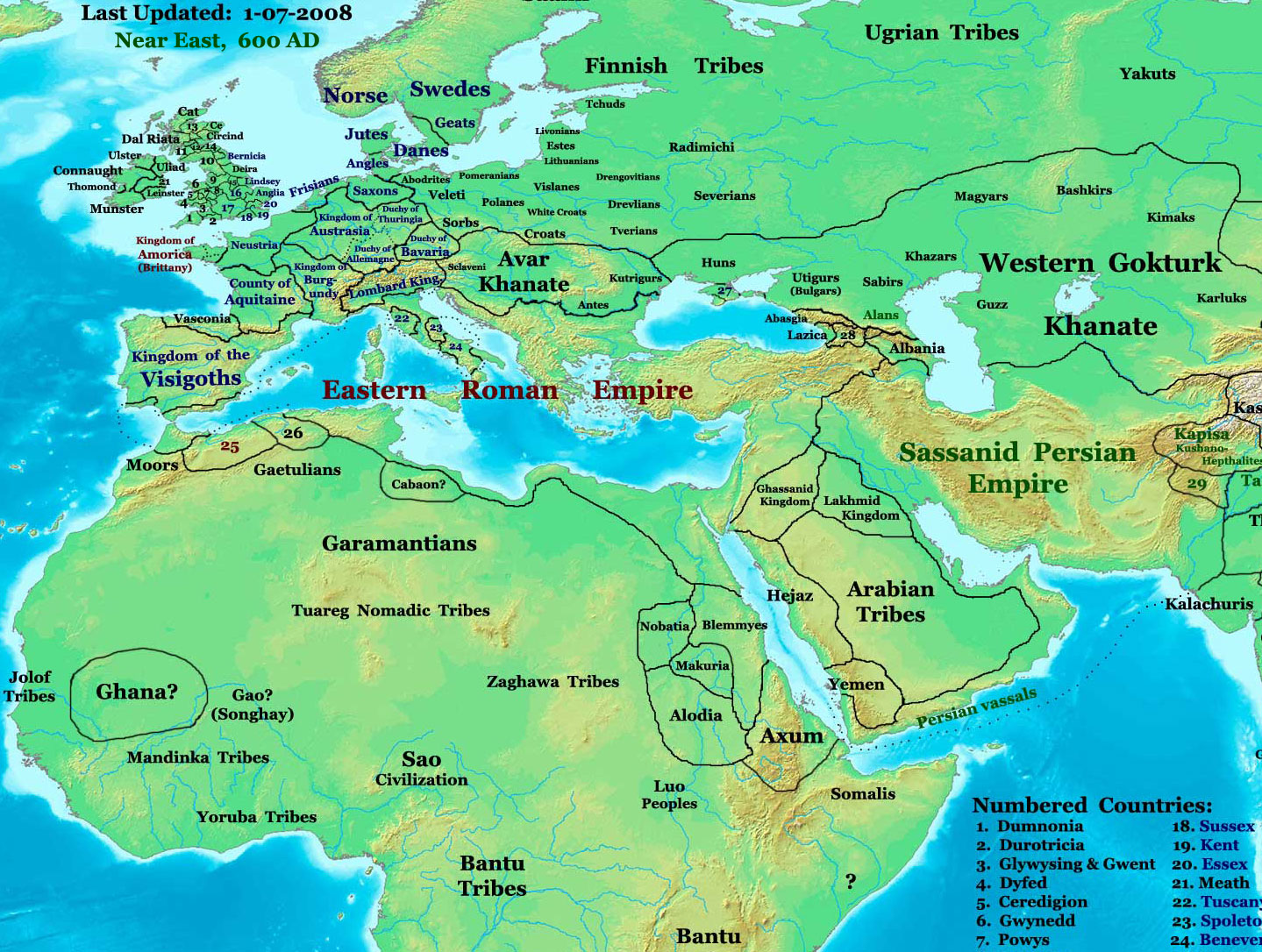
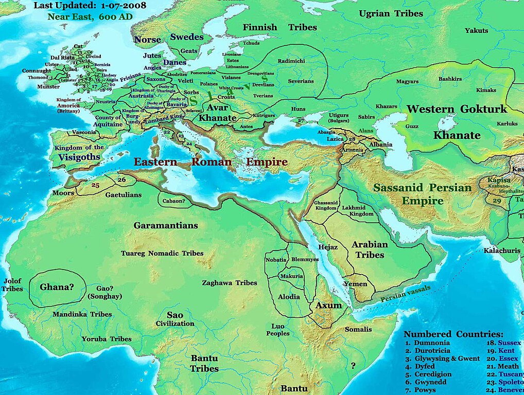
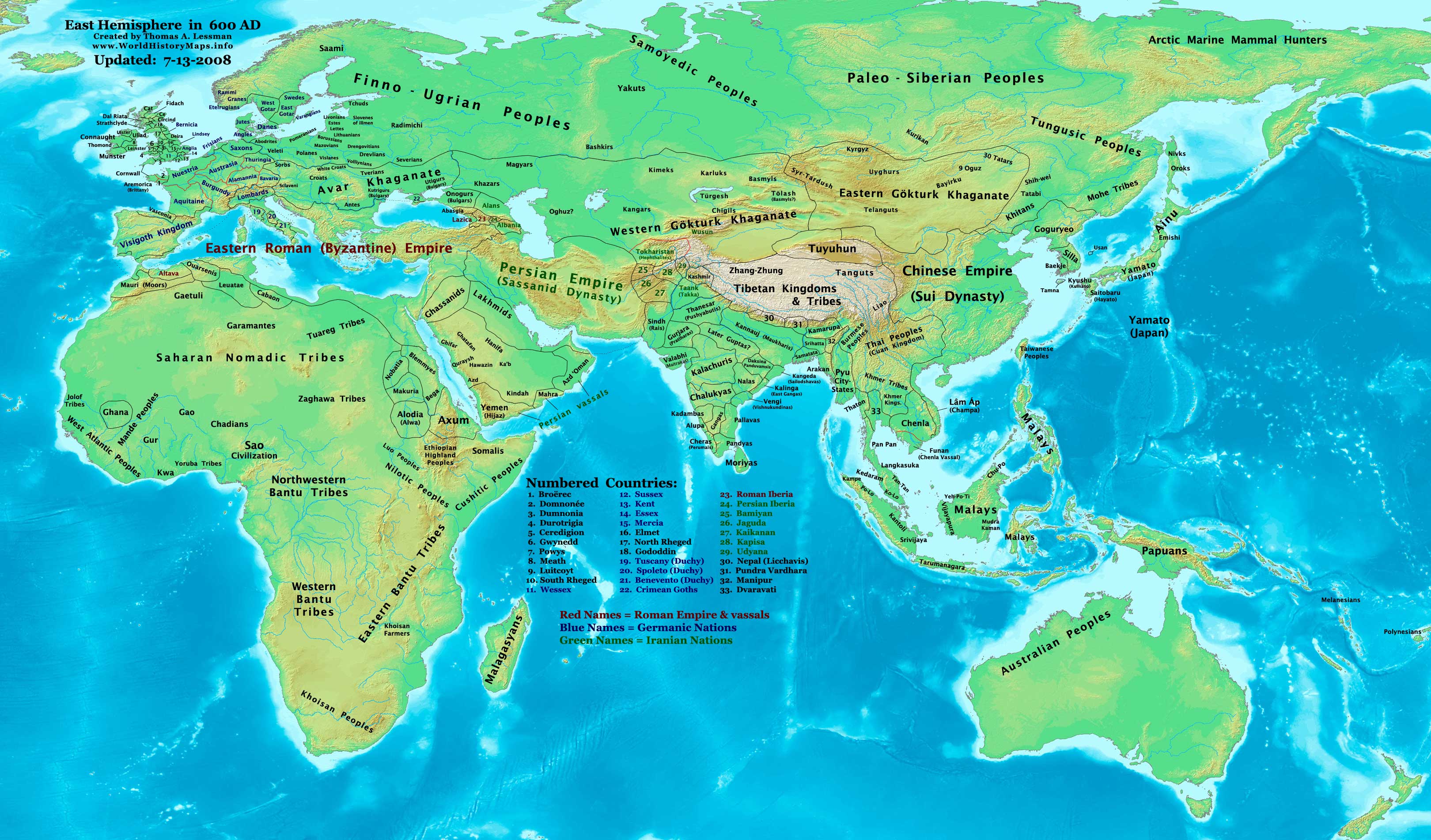
English: part of: Eastern Hemisphere in 600 AD.
Description: This image is a zoomed-in version of the Eastern Hemisphere in 600 AD. Author: Thomas A. Lessman (talessman@yis.us), later modified by others. Source URL: http://www.worldhistorymaps.info/images/East-Hem_600ad.jpg. Image Summary:Created by Thomas Lessman, based on this map of Eastern Hemisphere in 600 AD. Free for educational use. If you use this image, please credit the author (Thomas Lessman) and include (Source URL: http://www.worldhistorymaps.info/images/East-Hem_600ad.jpg). If you can help improve this map, please contact Thomas Lessman at talessman@yis.us. Other Historical Maps by Thomas Lessman
|
|||||||||||||||||||||||||
| 날짜 | 2008년 1월 17일 (원본 올리기 일시) | |||||||||||||||||||||||||
| 출처 | en.wikipedia에서 공용으로 옮겨왔습니다. | |||||||||||||||||||||||||
| 저자 | 영어 위키백과의 Talessman | |||||||||||||||||||||||||
| 저작권 (이 파일을 인용하기) |
|
|||||||||||||||||||||||||
| 다른 버전 | Disputed map because the version with « Romanised Dacians » (= Olahok, Vlachs) and « Slavs » (Totok, Slavons, Slovens...) may be a romanian and slavic POV, but this « Only Avars and no other people north of the Danube, in the future Kingdom of Hungary », according to the Eduard Rössler's « Awarenwüste » theory, shows an Austrian-Hungarian POV: one is not more objective than the other and unfortunately no synthesis is possible. | |||||||||||||||||||||||||
라이선스

|
GNU 자유 문서 사용 허가서 1.2판 또는 자유 소프트웨어 재단에서 발행한 이후 판의 규정에 따라 본 문서를 복제하거나 개작 및 배포할 수 있습니다. 본 문서에는 변경 불가 부분이 없으며, 앞 표지 구절과 뒷 표지 구절도 없습니다. 본 사용 허가서의 전체 내용은 GNU 자유 문서 사용 허가서 부분에 포함되어 있습니다. |
| 이 파일은 크리에이티브 커먼즈 저작자표시-동일조건변경허락 3.0 Unported 라이선스로 배포됩니다. | ||
| 저작자표시: Talessman at the English Wikipedia | ||
| ||
| 이 라이선스 틀은 GFDL 라이선스 변경의 일부로 이 파일에 추가되었습니다. |
| Maps of the eastern hemisphere showing history
Bold dates are available on Wikimedia or Wikipedia. | ||
| Primeval | ||
| Ancient
|
·| 600 BC | 550 BC | 527 BC | 500 BC |
400 BC | ·| 1 AD | 50 AD | 100 AD | 200 AD | 300 AD | | |
| Medieval |
·| 500 AD | 565 AD | 600 AD | 700 AD | | |
| Modern |
·| 1500 AD | · * For historical maps of the whole world, | |
·
기존 올리기 기록
- 2008-01-17 20:07 Talessman 1439×1086× (513542 bytes) Added more info for Africa, corrected some info on Europe.
- 2007-11-02 18:55 Talessman 1450×988× (440135 bytes) Corrected borders in Africa/Sudan and Arabia.
- 2007-10-31 20:30 Talessman 1429×927× (437106 bytes) Corrected borders of Ghana, made other names easier to read, other misc. corrections.
- 2007-10-21 00:19 Talessman 1251×779× (341469 bytes) Author: Thomas A. Lessman. Source URL: http://www.ThomasLessman.com/History/images/East-Hem_600ad.jpg. Image was created by me (Thomas Lessman) based on map of Eastern Hemisphere in 600ad. Image is free for public and/or educational use. I would appreciat
파일 역사
날짜/시간 링크를 클릭하면 해당 시간의 파일을 볼 수 있습니다.
| 날짜/시간 | 섬네일 | 크기 | 사용자 | 설명 | |
|---|---|---|---|---|---|
| 현재 | 2024년 6월 10일 (월) 01:54 | | 1,439 × 1,086 (502 KB) | OrionNimrod | Reverted to version as of 19:28, 26 September 2023 (UTC) restore original |
| 2024년 3월월 8일 (금) 02:26 |  | 1,439 × 1,086 (1.14 MB) | Nihil scimus | Restored a more accurate map uploaded march 15, 2023 by Moodylo333: Armenia was not Byzantine (see Claude Murafian's & Eric Van Lauwe's ''Atlas historique de l'Arménie'', Autrement publ., ISBN 2746701006); Highlighted the boundaries of the Eastern Roman Empire, Sassanid Persia and the Göktürk Khanate; Drawn the Slavic perimeter and reduced the Avar perimeter (greatly exaggerated) according to [https://commons.wikimedia.org/wiki/File:Avar_settlement_area.jpg] and to Vladislav Popovic's «La des... | |
| 2023년 9월 27일 (수) 04:28 |  | 1,439 × 1,086 (502 KB) | OrionNimrod | Reverted to version as of 09:20, 1 February 2009 (UTC) keep original | |
| 2023년 3월월 16일 (목) 01:28 |  | 1,439 × 1,086 (1.14 MB) | Moodylo333 | More accurate map: see explanations. | |
| 2022년 10월 28일 (금) 22:38 |  | 1,439 × 1,086 (502 KB) | OrionNimrod | Reverted to version as of 09:20, 1 February 2009 (UTC) "Romance Dacians in 600" in Transylvania is clearly a Romanian nationalist POV, and there is Avar archeological sites, but the Avar territory was decreased in the updated map. Dacians in 600??? | |
| 2022년 10월 28일 (금) 00:47 |  | 1,439 × 1,086 (744 KB) | Nihil scimus | Modifications from academic historical books do not "invent nations" or falsifie Commons' digital incomplete maps, but enrich them. | |
| 2022년 10월 7일 (금) 02:29 |  | 1,439 × 1,086 (502 KB) | OrionNimrod | Reverted to version as of 09:20, 1 February 2009 (UTC) restored the original one which was extract from the big original map, the map was falsified with did not exist nations at that time 600 AD | |
| 2014년 12월 11일 (목) 21:55 |  | 1,439 × 1,086 (744 KB) | Spiridon Ion Cepleanu | Garamantian & Arabic tribes areas | |
| 2014년 11월 21일 (금) 02:26 |  | 1,439 × 1,086 (742 KB) | Spiridon Ion Cepleanu | Lakes & Caspian shorelines | |
| 2014년 11월 15일 (토) 22:21 |  | 1,439 × 1,086 (737 KB) | Spiridon Ion Cepleanu | Add missing names: Altava, Warsenia, Iberia, Kaikanan |
이 파일을 사용하는 문서
다음 문서 1개가 이 파일을 사용하고 있습니다:
이 파일을 사용하고 있는 모든 위키의 문서 목록
다음 위키에서 이 파일을 사용하고 있습니다:
- ast.wikipedia.org에서 이 파일을 사용하고 있는 문서 목록
- az.wikipedia.org에서 이 파일을 사용하고 있는 문서 목록
- ba.wikipedia.org에서 이 파일을 사용하고 있는 문서 목록
- bg.wikipedia.org에서 이 파일을 사용하고 있는 문서 목록
- ca.wikipedia.org에서 이 파일을 사용하고 있는 문서 목록
- cv.wikipedia.org에서 이 파일을 사용하고 있는 문서 목록
- el.wikipedia.org에서 이 파일을 사용하고 있는 문서 목록
- en.wikipedia.org에서 이 파일을 사용하고 있는 문서 목록
- en.wikiversity.org에서 이 파일을 사용하고 있는 문서 목록
- es.wikipedia.org에서 이 파일을 사용하고 있는 문서 목록
- fa.wikipedia.org에서 이 파일을 사용하고 있는 문서 목록
- fr.wikipedia.org에서 이 파일을 사용하고 있는 문서 목록
- hu.wikipedia.org에서 이 파일을 사용하고 있는 문서 목록
- id.wikipedia.org에서 이 파일을 사용하고 있는 문서 목록
- it.wikipedia.org에서 이 파일을 사용하고 있는 문서 목록
- ja.wikipedia.org에서 이 파일을 사용하고 있는 문서 목록
- lt.wikipedia.org에서 이 파일을 사용하고 있는 문서 목록
이 파일의 더 많은 사용 내역을 봅니다.