파일:PIA17202 - Approaching Enceladus.jpg
미리 보기 크기: 600 × 600 픽셀 다른 해상도: 240 × 240 픽셀 | 480 × 480 픽셀 | 1,020 × 1,020 픽셀
원본 파일 (1,020 × 1,020 픽셀, 파일 크기: 1.1 MB, MIME 종류: image/jpeg)
파일 설명
| 설명 |
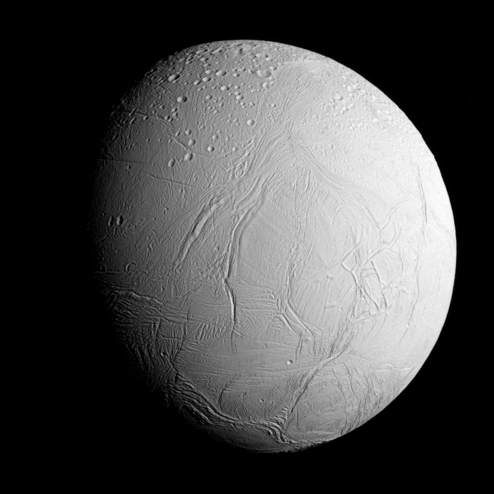
English: Original caption: NASA's Cassini spacecraft captured this view as it neared icy Enceladus for its closest-ever dive past the moon's active south polar region. The view shows heavily cratered northern latitudes at top, transitioning to fractured, wrinkled terrain in the middle and southern latitudes. The wavy boundary of the moon's active south polar region -- Cassini's destination for this flyby -- is visible at bottom, where it disappears into wintry darkness.
This view looks towards the Saturn-facing side of Enceladus. North on Enceladus is up and rotated 23 degrees to the right. The image was taken in visible light with the Cassini spacecraft narrow-angle camera on Oct. 28, 2015. The view was acquired at a distance of approximately 60,000 miles (96,000 kilometers) from Enceladus and at a Sun-Enceladus-spacecraft, or phase, angle of 45 degrees. Image scale is 1,896 feet (578 meters) per pixel. |
| 날짜 | |
| 출처 | PIA17202 from the NASA/JPL Photojournal |
| 저자 | National Aeronautics and Space Administration (NASA) / Jet Propulsion Laboratory (JPL) |
라이선스
| 이 파일은 NASA에서 제작하였으므로 퍼블릭 도메인입니다. NASA의 저작권 정책에 따르면 NASA의 자료는 명시하지 않는 이상 저작권의 보호를 받지 않습니다. (Template:PD-USGov, 또는 NASA 저작권 정책 문서, JPL 그림 사용 정책을 참고하세요.) | ||
 |
주의사항:
|
파일 역사
날짜/시간 링크를 클릭하면 해당 시간의 파일을 볼 수 있습니다.
| 날짜/시간 | 섬네일 | 크기 | 사용자 | 설명 | |
|---|---|---|---|---|---|
| 현재 | 2020년 10월 8일 (목) 16:20 | | 1,020 × 1,020 (1.1 MB) | Vlixes | from tiff, rgb |
| 2015년 10월 31일 (토) 08:16 |  | 920 × 920 (191 KB) | PhilipTerryGraham | User created page with UploadWizard |
이 파일을 사용하는 문서
다음 문서 2개가 이 파일을 사용하고 있습니다:
이 파일을 사용하고 있는 모든 위키의 문서 목록
다음 위키에서 이 파일을 사용하고 있습니다:
- an.wikipedia.org에서 이 파일을 사용하고 있는 문서 목록
- ary.wikipedia.org에서 이 파일을 사용하고 있는 문서 목록
- arz.wikipedia.org에서 이 파일을 사용하고 있는 문서 목록
- azb.wikipedia.org에서 이 파일을 사용하고 있는 문서 목록
- bn.wikibooks.org에서 이 파일을 사용하고 있는 문서 목록
- bs.wikipedia.org에서 이 파일을 사용하고 있는 문서 목록
- ca.wikipedia.org에서 이 파일을 사용하고 있는 문서 목록
- ckb.wikipedia.org에서 이 파일을 사용하고 있는 문서 목록
- cs.wikipedia.org에서 이 파일을 사용하고 있는 문서 목록
- el.wikipedia.org에서 이 파일을 사용하고 있는 문서 목록
- en.wikipedia.org에서 이 파일을 사용하고 있는 문서 목록
- Pioneer 11
- Cassini–Huygens
- Enceladus
- Moons of Saturn
- Naming of moons
- List of natural satellites
- Dunyazad (crater)
- Ahmad (crater)
- Peri-Banu (crater)
- Aladdin (crater)
- Ali Baba (crater)
- Julnar (crater)
- Salih (crater)
- Dalilah (crater)
- Samad (crater)
- Musa (crater)
- Gharib (crater)
- Duban (crater)
- Shahryar (crater)
- Sindbad (crater)
- Daryabar Fossa
- Bassorah Fossa
- List of gravitationally rounded objects of the Solar System
- Al-Fakik
- Marjanah (crater)
- Ayyub (crater)
- Fitnah (crater)
- Ghanim (crater)
- Al-Haddar
- Sharrkan (crater)
- Khusrau (crater)
이 파일의 더 많은 사용 내역을 봅니다.