파일:Paricutin 30 612.jpg

미리 보기 크기: 400 × 600 픽셀 다른 해상도: 160 × 240 픽셀 | 320 × 480 픽셀 | 667 × 1,000 픽셀
원본 파일 (667 × 1,000 픽셀, 파일 크기: 53 KB, MIME 종류: image/jpeg)
파일 설명
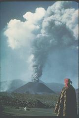
| 설명 | This slide shows the cinder cone soon after its birth in 1943 in a Mexican cornfield. During its brief nine-year lifespan (1943-1952), it built a 410-meter-high cone with extensive lava fields around the base of the cone. Most of the 2 km3 of eruptive products (ash, cinders, and lava) were produced in the first few years. Cinder cones such as this one are commonly formed by one eruption. Each subsequent eruption in the same area forms its own cinder cone. |
| 날짜 | |
| 출처 | http://www.ngdc.noaa.gov/seg/hazard/slideset/30/30_612_slide.shtml |
| 저자 | Photo credit: K. Segerstrom, U.S. Geological Survey |
| 저작권 (이 파일을 인용하기) |
PD-USGov-NOAA |
|
|
파일 역사
날짜/시간 링크를 클릭하면 해당 시간의 파일을 볼 수 있습니다.
| 날짜/시간 | 섬네일 | 크기 | 사용자 | 설명 | |
|---|---|---|---|---|---|
| 현재 | 2006년 10월 18일 (수) 05:31 | | 667 × 1,000 (53 KB) | Alhen | {{Information |Description= Paricutin, Mexico;19.48 N 102.25 W;3,170 m elevation This slide shows the cinder cone soon after its birth in 1943 in a Mexican cornfield. During its brief nine-year lifespan (1943-1952), it built a 410-mete |
| 2006년 10월 18일 (수) 05:18 |  | 667 × 1,000 (49 KB) | Alhen | {{Information |Description= w:Paricutin, Mexico;19.48 N 102.25 W;3,170 m elevation This slide shows the cinder cone soon after its birth in 1943 in a Mexican cornfield. During its brief nine-year lifespan (1943-1952), it built a 410-meter-high co |
이 파일을 사용하는 문서
다음 문서 1개가 이 파일을 사용하고 있습니다:
이 파일을 사용하고 있는 모든 위키의 문서 목록
다음 위키에서 이 파일을 사용하고 있습니다:
- ar.wikipedia.org에서 이 파일을 사용하고 있는 문서 목록
- ast.wikipedia.org에서 이 파일을 사용하고 있는 문서 목록
- ca.wikipedia.org에서 이 파일을 사용하고 있는 문서 목록
- de.wikipedia.org에서 이 파일을 사용하고 있는 문서 목록
- dv.wikipedia.org에서 이 파일을 사용하고 있는 문서 목록
- el.wikipedia.org에서 이 파일을 사용하고 있는 문서 목록
- en.wikipedia.org에서 이 파일을 사용하고 있는 문서 목록
- en.wikibooks.org에서 이 파일을 사용하고 있는 문서 목록
- es.wikipedia.org에서 이 파일을 사용하고 있는 문서 목록
- fa.wikipedia.org에서 이 파일을 사용하고 있는 문서 목록
- fr.wikipedia.org에서 이 파일을 사용하고 있는 문서 목록
- hu.wikipedia.org에서 이 파일을 사용하고 있는 문서 목록
- it.wikipedia.org에서 이 파일을 사용하고 있는 문서 목록
- ja.wikipedia.org에서 이 파일을 사용하고 있는 문서 목록
- lt.wikipedia.org에서 이 파일을 사용하고 있는 문서 목록
- mk.wikipedia.org에서 이 파일을 사용하고 있는 문서 목록
- mr.wikipedia.org에서 이 파일을 사용하고 있는 문서 목록
- nah.wikipedia.org에서 이 파일을 사용하고 있는 문서 목록
- nn.wikipedia.org에서 이 파일을 사용하고 있는 문서 목록
- no.wikipedia.org에서 이 파일을 사용하고 있는 문서 목록
- oc.wikipedia.org에서 이 파일을 사용하고 있는 문서 목록
- pl.wikipedia.org에서 이 파일을 사용하고 있는 문서 목록
- ro.wikipedia.org에서 이 파일을 사용하고 있는 문서 목록
- ru.wikipedia.org에서 이 파일을 사용하고 있는 문서 목록
- sh.wikipedia.org에서 이 파일을 사용하고 있는 문서 목록
- tr.wikipedia.org에서 이 파일을 사용하고 있는 문서 목록
- uk.wikipedia.org에서 이 파일을 사용하고 있는 문서 목록