원본 파일 (894 × 899 픽셀, 파일 크기: 39 KB, MIME 종류: image/png )
파일 설명 Español:
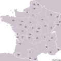
Pre-Republican provinces of France , numbered according to union with France , with provincial capitals marked.
Created by reference to a 1952 Nouveau Petit Larousse by User:OwenBlacker and licenced under the GFDL .
Provinces as follows, in the format English name (French name , Year of union; Capital):
Royal Domain (Île-de-France 987 , Paris )Berry (Berry 1101 , Bourges )Duchy of Orléanais (Orléanais 1198 , Orléans )Normandy (Normandie 1204 , Rouen )Languedoc , mainly the County of Toulouse (Languedoc 1270 , Toulouse )Lyonnais (Lyonnais 1313 , Lyon )Dauphiné , (Dauphiné 1349 , Grenoble )County of Champagne (Champagne 1361 , Troyes )Aunis , a fief of Aquitaine (Aunis 1371 , La Rochelle )Saintonge (Saintonge 1371 , Saintes )Poitou (Poitou 1416 , Poitiers )Duchy of Aquitaine (Aquitaine 1453 , Bordeaux ), taken from England and split into provinces of Gascogne (Armagnac ) and Guyenne (Bordeaux ), but excluding the viscounties of Foix, Béarn, Bigorre and Périgord (kept by Navarre )Duchy of Burgundy (Bourgogne 1477 , Dijon )Picardy (Picardie 1482 , Amiens )Anjou (Anjou 1482 , Angers )County of Provence (Provence 1482 , Aix-en-Provence )County of Angoulême (Angoumois 1515 , Angoulême )Duchy of Bourbon (Bourbonnais 1527 , Moulins )La Marche (Marche 1527 , Guéret )Duchy of Britanny (Bretagne 1532 , Rennes )County of Maine (Maine 1584 , Le Mans ) and County of Perche (Perche 1525 , Nogent-le-Rotrou )Touraine (Touraine 1584 , Tours )Limousin (Limousin 1589 , Limoges ), excluding Viscounty of Périgord (kept by Navarre )County of Foix (Comté de Foix 1607 , Foix ) and Viscounty of Périgord (Périgord , 1607, Périgueux , attached to province of Guyenne), both former fiefs from NavarreDuchy of Auvergne (Auvergne 1610 , Clermont-Ferrand )Viscounty of Béarn (Béarn 1620 , Pau )Alsace (Alsace 1648 , Strasbourg )County of Artois , a fief of the w:Habsburgs ' Spanish Netherlands (Artois 1659 , Arras )Roussillon (Roussillon 1659 , Perpignan )Flanders , a fief of the w:Habsburgs ' Spanish Netherlands (Flandre 1668 , Lille )Free County of Burgundy (Franche-Comté 1678 , Besançon )Duchy of Lorraine , a personal territory of Stanisław I of Poland within the Holy Roman Empire (Lorraine 1766 , Nancy )Corsica (off map, Corse 1768 , Ajaccio )The following were not provinces of France before the Revolution, but joined or were annexed to France after it, when departments had replaced all former provinces: Duchy of Nivernais (Nivernais 1789 , Nevers )Comtat Venaissin , a Papal fief (Comtat Venaissain 1791 , Avignon )Imperial Free City of Mulhouse (Mulhouse 1798 )Duchy of Savoy , a state of the Kingdom of Sardinia-Piedmont (Savoie 1860 , Chambéry )County of Nice , a state of the Kingdom of Sardinia-Piedmont (Comté de Nice 1860 , Nice )Principality of Montbéliard (Montbéliard 1816 , Montbéliard )Free cities of Menton and Roquebrune (1861 ), joining France after the separation (under the protectorate of Sardinia ) in 1848 from Monaco
GNU 자유 문서 사용 허가서 자유 소프트웨어 재단 에서 발행한 이후 판의 규정에 따라 본 문서를 복제하거나 개작 및 배포할 수 있습니다. 본 문서에는 변경 불가 부분이 없으며, 앞 표지 구절과 뒷 표지 구절도 없습니다. 본 사용 허가서의 전체 내용은 GNU 자유 문서 사용 허가서 부분에 포함되어 있습니다.http://www.gnu.org/copyleft/fdl.html GFDL GNU Free Documentation License true true
이 파일은 크리에이티브 커먼즈 저작자표시-동일조건변경허락 3.0 Unported 라이선스로 배포됩니다.
이용자는 다음의 권리를 갖습니다:
공유 및 이용 – 저작물의 복제, 배포, 전시, 공연 및 공중송신재창작 – 저작물의 개작, 수정, 2차적저작물 창작
다음과 같은 조건을 따라야 합니다:
저작자표시 – 적절한 저작자 표시를 제공하고, 라이센스에 대한 링크를 제공하고, 변경사항이 있는지를 표시해야 합니다. 당신은 합리적인 방식으로 표시할 수 있지만, 어떤 방식으로든 사용권 허가자가 당신 또는 당신의 사용을 지지하는 방식으로 표시할 수 없습니다.동일조건변경허락 – 만약 당신이 이 저작물을 리믹스 또는 변형하거나 이 저작물을 기반으로 제작하는 경우, 당신은 당신의 기여물을 원저작물과 동일하거나 호환 가능한 라이선스 에 따라 배포하여야 합니다.
이 라이선스 틀은 GFDL 라이선스 변경 의 일부로 이 파일에 추가되었습니다. http://creativecommons.org/licenses/by-sa/3.0/ CC BY-SA 3.0 Creative Commons Attribution-Share Alike 3.0 true true
derivative works 이 파일은 다음으로 파생됨: Forteresses marches de Bretagne.png
한국어 이 파일이 나타내는 바에 대한 한 줄 설명을 추가합니다
파일 역사
이 파일을 사용하는 문서
다음 문서 32개가 이 파일을 사용하고 있습니다:
이 파일을 사용하고 있는 모든 위키의 문서 목록
다음 위키에서 이 파일을 사용하고 있습니다:
an.wikipedia.org에서 이 파일을 사용하고 있는 문서 목록
ar.wikipedia.org에서 이 파일을 사용하고 있는 문서 목록
이 파일의 더 많은 사용 내역 을 봅니다.


