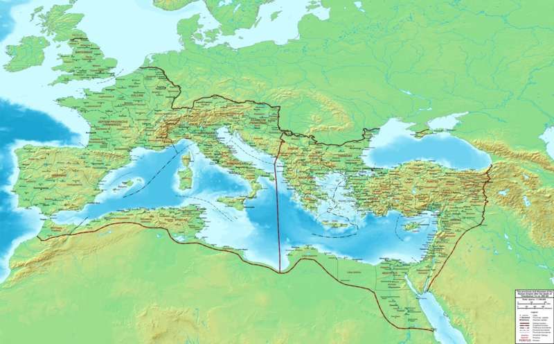
파일:The Roman Empire ca 400 AD.png

미리 보기 크기: 800 × 496 픽셀 다른 해상도: 320 × 198 픽셀 | 640 × 397 픽셀 | 1,024 × 635 픽셀 | 1,280 × 793 픽셀 | 2,560 × 1,587 픽셀 | 4,339 × 2,689 픽셀
원본 파일 (4,339 × 2,689 픽셀, 파일 크기: 12.8 MB, MIME 종류: image/png)
파일 역사
날짜/시간 링크를 클릭하면 해당 시간의 파일을 볼 수 있습니다.
| 날짜/시간 | 섬네일 | 크기 | 사용자 | 설명 | |
|---|---|---|---|---|---|
| 현재 | 2015년 2월 20일 (금) 07:27 |  | 4,339 × 2,689 (12.8 MB) | Cplakidas | added potential location of Valentia beyond Hadrian's Wall, removed provincial boundaries in Britannia as too tentative |
| 2011년 7월 21일 (목) 22:03 |  | 4,339 × 2,689 (10.9 MB) | Cplakidas | fixed Persian border, differentiated between Eastern and Western empire, different borders for praet. prefectures | |
| 2009년 3월 21일 (토) 11:37 |  | 4,475 × 2,600 (9.99 MB) | Cplakidas | minor corrections | |
| 2008년 5월 29일 (목) 21:30 |  | 3,800 × 2,370 (8.1 MB) | Cplakidas | ||
| 2008년 5월 29일 (목) 21:17 |  | 4,560 × 2,850 (11.22 MB) | Cplakidas | clearer version & addition of the Armenian satrapies | |
| 2007년 12월 30일 (일) 11:02 |  | 3,380 × 2,120 (5.96 MB) | Cplakidas | added names of dioceses, legend box, various minor adjustments | |
| 2007년 12월 13일 (목) 23:27 |  | 3,550 × 2,200 (6.65 MB) | Cplakidas | new improved version made with Inkscape, slight corrections in borders, added several cities in Africa & Spain | |
| 2007년 11월 13일 (화) 04:27 |  | 3,550 × 2,200 (4.75 MB) | Cplakidas | minor corrections in southern Gaul | |
| 2007년 11월 5일 (월) 21:58 |  | 3,550 × 2,200 (4.75 MB) | Cplakidas | New version, with some corrections & additions | |
| 2007년 11월 1일 (목) 01:55 |  | 3,436 × 2,142 (4.5 MB) | Cplakidas | {{Information |Description=Map of the Roman Empire ca. 400 AD, showing the administrative division into dioceses and provinces, as well as the major cities. The demarcation between Eastern and Western Empires is noted in red. |Source=Base map found at |
이 파일을 사용하는 문서
다음 문서 2개가 이 파일을 사용하고 있습니다:
이 파일을 사용하고 있는 모든 위키의 문서 목록
다음 위키에서 이 파일을 사용하고 있습니다:
- af.wikipedia.org에서 이 파일을 사용하고 있는 문서 목록
- ar.wikipedia.org에서 이 파일을 사용하고 있는 문서 목록
- ary.wikipedia.org에서 이 파일을 사용하고 있는 문서 목록
- ast.wikipedia.org에서 이 파일을 사용하고 있는 문서 목록
- bg.wikipedia.org에서 이 파일을 사용하고 있는 문서 목록
- bn.wikipedia.org에서 이 파일을 사용하고 있는 문서 목록
- ca.wikipedia.org에서 이 파일을 사용하고 있는 문서 목록
- ceb.wikipedia.org에서 이 파일을 사용하고 있는 문서 목록
- cs.wikipedia.org에서 이 파일을 사용하고 있는 문서 목록
- de.wikipedia.org에서 이 파일을 사용하고 있는 문서 목록
- el.wikipedia.org에서 이 파일을 사용하고 있는 문서 목록
- en.wikipedia.org에서 이 파일을 사용하고 있는 문서 목록
- eo.wikipedia.org에서 이 파일을 사용하고 있는 문서 목록
- es.wikipedia.org에서 이 파일을 사용하고 있는 문서 목록
- et.wikipedia.org에서 이 파일을 사용하고 있는 문서 목록
- fr.wikipedia.org에서 이 파일을 사용하고 있는 문서 목록
- he.wikipedia.org에서 이 파일을 사용하고 있는 문서 목록
- hi.wikipedia.org에서 이 파일을 사용하고 있는 문서 목록
- hr.wikipedia.org에서 이 파일을 사용하고 있는 문서 목록
- hu.wikipedia.org에서 이 파일을 사용하고 있는 문서 목록
- id.wikipedia.org에서 이 파일을 사용하고 있는 문서 목록
- it.wikipedia.org에서 이 파일을 사용하고 있는 문서 목록
- la.wikipedia.org에서 이 파일을 사용하고 있는 문서 목록
- lt.wikipedia.org에서 이 파일을 사용하고 있는 문서 목록
- nl.wikipedia.org에서 이 파일을 사용하고 있는 문서 목록
이 파일의 더 많은 사용 내역을 봅니다.


