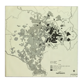
파일:US Strategic Bombing of Tokyo 1944-1945.png

미리 보기 크기: 600 × 600 픽셀 다른 해상도: 240 × 240 픽셀 | 480 × 480 픽셀 | 768 × 768 픽셀 | 1,024 × 1,024 픽셀 | 2,048 × 2,048 픽셀 | 3,072 × 3,072 픽셀
원본 파일 (3,072 × 3,072 픽셀, 파일 크기: 2.57 MB, MIME 종류: image/png)
파일 역사
날짜/시간 링크를 클릭하면 해당 시간의 파일을 볼 수 있습니다.
| 날짜/시간 | 섬네일 | 크기 | 사용자 | 설명 | |
|---|---|---|---|---|---|
| 현재 | 2014년 3월 4일 (화) 10:59 |  | 3,072 × 3,072 (2.57 MB) | Mopenstein | Apparently I uploaded the incorrect file last time. This is the correct repaired image |
| 2014년 3월 4일 (화) 10:57 |  | 3,072 × 3,072 (2.57 MB) | Mopenstein | Fixed patch of blurred image increasing the definition | |
| 2009년 10월 6일 (화) 06:11 |  | 3,072 × 3,072 (2.79 MB) | Andy Anderson | {{Information |Description={{en|1="Effects of air attack on urban complex Tokyo-Kawasaki-Yokohama". Map of the U.S. strategic bombing campaign on Tokyo from November 29, 1944 - March 9, 1945 Image extracted from PDF of original document and saved as PNG, |
이 파일을 사용하는 문서
다음 문서 1개가 이 파일을 사용하고 있습니다:
이 파일을 사용하고 있는 모든 위키의 문서 목록
다음 위키에서 이 파일을 사용하고 있습니다:
- azb.wikipedia.org에서 이 파일을 사용하고 있는 문서 목록
- ca.wikipedia.org에서 이 파일을 사용하고 있는 문서 목록
- cs.wikipedia.org에서 이 파일을 사용하고 있는 문서 목록
- de.wikipedia.org에서 이 파일을 사용하고 있는 문서 목록
- en.wikipedia.org에서 이 파일을 사용하고 있는 문서 목록
- eu.wikipedia.org에서 이 파일을 사용하고 있는 문서 목록
- fr.wikipedia.org에서 이 파일을 사용하고 있는 문서 목록
- id.wikipedia.org에서 이 파일을 사용하고 있는 문서 목록
- ja.wikipedia.org에서 이 파일을 사용하고 있는 문서 목록
- no.wikipedia.org에서 이 파일을 사용하고 있는 문서 목록
- vi.wikipedia.org에서 이 파일을 사용하고 있는 문서 목록
- www.wikidata.org에서 이 파일을 사용하고 있는 문서 목록
- zh.wikipedia.org에서 이 파일을 사용하고 있는 문서 목록
