파일:Union Pacific Railroad system map.svg

SVG 파일의 PNG 형식의 미리보기 크기: 800 × 457 픽셀. 다른 해상도: 320 × 183 픽셀 | 640 × 366 픽셀 | 1,024 × 585 픽셀 | 1,280 × 731 픽셀 | 2,560 × 1,463 픽셀 | 1,400 × 800 픽셀
원본 파일 (SVG 파일, 실제 크기 1,400 × 800 픽셀, 파일 크기: 1.56 MB)
파일 설명
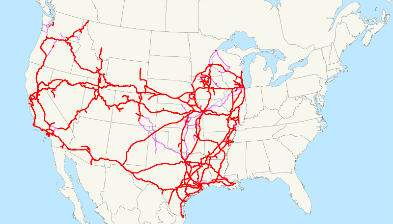
| 설명 | This is a map of the Union Pacific Railroad as of 2008, with trackage rights in purple (the special Chicago-Kansas City intermodal trackage rights are lighter). Email me if you would like a copy of the GIS data I created (modified from Bureau of Transportation Statistics North American Transportation Atlas Data) or if you see any errors. |
| 날짜 | 2008년 8월 26일 (원본 올리기 일시) |
| 출처 | No machine-readable source provided. Own work assumed (based on copyright claims). |
| 저자 | No machine-readable author provided. NE2 assumed (based on copyright claims). |
라이선스
| 나는 이 작품의 저작권자로서, 이 작품을 퍼블릭 도메인으로 모두에게 공개합니다. 이 공개 선언은 전 세계적으로 유효합니다. 만약 저작권의 포기가 법률적으로 가능하지 않은 경우, 나는 이 작품을 법적으로 허용되는 한도 내에서 누구나 자유롭게 어떤 목적으로도 제한없이 사용할 수 있도록 허용합니다. |
파일 역사
날짜/시간 링크를 클릭하면 해당 시간의 파일을 볼 수 있습니다.
| 날짜/시간 | 섬네일 | 크기 | 사용자 | 설명 | |
|---|---|---|---|---|---|
| 현재 | 2009년 3월월 18일 (수) 13:52 | | 1,400 × 800 (1.56 MB) | NE2 | Verifying that nothing has gotten screwed up. |
| 2009년 2월월 23일 (월) 22:08 |  | 1,400 × 800 (1.54 MB) | NE2 | Changed the display of lines owned by the government for the purposes of passenger rail, so that if UP is the primary freight operator it is not shown as trackage rights. | |
| 2009년 1월월 15일 (목) 20:03 |  | 1,400 × 800 (1.51 MB) | NE2 | Just checking that I haven't lost any data over the months. | |
| 2008년 8월 27일 (수) 08:09 |  | 1,120 × 640 (1.47 MB) | NE2 | == Summary == This is a map of the Union Pacific Railroad as of 2008, with w:trackage rights in purple (the special Chicago-Kansas City intermodal trackage rights are lighter). Email me if you would like a copy of the GIS d |
이 파일을 사용하는 문서
다음 문서 1개가 이 파일을 사용하고 있습니다:
이 파일을 사용하고 있는 모든 위키의 문서 목록
다음 위키에서 이 파일을 사용하고 있습니다:
- da.wikipedia.org에서 이 파일을 사용하고 있는 문서 목록
- de.wikipedia.org에서 이 파일을 사용하고 있는 문서 목록
- en.wikipedia.org에서 이 파일을 사용하고 있는 문서 목록
- eo.wikipedia.org에서 이 파일을 사용하고 있는 문서 목록
- es.wikipedia.org에서 이 파일을 사용하고 있는 문서 목록
- fa.wikipedia.org에서 이 파일을 사용하고 있는 문서 목록
- fi.wikipedia.org에서 이 파일을 사용하고 있는 문서 목록
- fr.wikipedia.org에서 이 파일을 사용하고 있는 문서 목록
- he.wikipedia.org에서 이 파일을 사용하고 있는 문서 목록
- hu.wikipedia.org에서 이 파일을 사용하고 있는 문서 목록
- id.wikipedia.org에서 이 파일을 사용하고 있는 문서 목록
- it.wikipedia.org에서 이 파일을 사용하고 있는 문서 목록
- ja.wikipedia.org에서 이 파일을 사용하고 있는 문서 목록
- ms.wikipedia.org에서 이 파일을 사용하고 있는 문서 목록
- mt.wikipedia.org에서 이 파일을 사용하고 있는 문서 목록
- nl.wikipedia.org에서 이 파일을 사용하고 있는 문서 목록
- no.wikipedia.org에서 이 파일을 사용하고 있는 문서 목록
- pl.wikipedia.org에서 이 파일을 사용하고 있는 문서 목록
- pt.wikipedia.org에서 이 파일을 사용하고 있는 문서 목록
- ro.wikipedia.org에서 이 파일을 사용하고 있는 문서 목록
- ru.wikipedia.org에서 이 파일을 사용하고 있는 문서 목록
- simple.wikipedia.org에서 이 파일을 사용하고 있는 문서 목록
- sk.wikipedia.org에서 이 파일을 사용하고 있는 문서 목록
- sv.wikipedia.org에서 이 파일을 사용하고 있는 문서 목록
- uk.wikipedia.org에서 이 파일을 사용하고 있는 문서 목록
- www.wikidata.org에서 이 파일을 사용하고 있는 문서 목록
- zh-min-nan.wikipedia.org에서 이 파일을 사용하고 있는 문서 목록
- zh.wikipedia.org에서 이 파일을 사용하고 있는 문서 목록