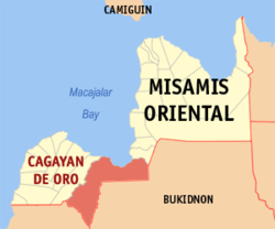
카가얀데오로
카가얀데오로(영어: City of Cagayan de Oro, 힐리가이논어: Dakbayan sa Cagayan de Oro, 타갈로그어: Lungsod ng Cagayan de Oro)는 필리핀 동미사미스주의 주도로, 민다나오섬 북부 연안에 위치하며 면적은 488.86km2, 인구는 675,950명(2015년 기준)이다. 북민다나오 지방의 행정 중심지 역할을 겸한다.

인구
편집| 연도 | 인구 | ±% p.a. |
|---|---|---|
| 1903 | 10,937 | — |
| 1918 | 28,062 | +6.48% |
| 1939 | 53,194 | +3.09% |
| 1948 | 54,293 | +0.23% |
| 1960 | 68,274 | +1.93% |
| 1970 | 128,319 | +6.51% |
| 1975 | 165,220 | +5.20% |
| 1980 | 227,312 | +6.59% |
| 1990 | 339,598 | +4.10% |
| 1995 | 428,314 | +4.44% |
| 2000 | 461,877 | +1.63% |
| 2010 | 602,088 | +2.69% |
| 2015 | 675,950 | +2.23% |
| 2020 | 728,402 | +1.48% |
| Source: Philippine Statistics Authority [1] [2] [3][4] | ||
기후
편집| Cagayan de Oro (Lumbia Airport) 1981–2010, extremes 1979–2012의 기후 | |||||||||||||
|---|---|---|---|---|---|---|---|---|---|---|---|---|---|
| 월 | 1월 | 2월 | 3월 | 4월 | 5월 | 6월 | 7월 | 8월 | 9월 | 10월 | 11월 | 12월 | 연간 |
| 최고 기온 기록 °C (°F) | 35.0 (95.0) |
36.0 (96.8) |
37.6 (99.7) |
37.0 (98.6) |
38.2 (100.8) |
38.4 (101.1) |
36.2 (97.2) |
37.8 (100.0) |
36.7 (98.1) |
39.0 (102.2) |
34.7 (94.5) |
34.4 (93.9) |
39.0 (102.2) |
| 평균 일 최고 기온 °C (°F) | 29.6 (85.3) |
30.2 (86.4) |
31.3 (88.3) |
32.5 (90.5) |
32.9 (91.2) |
32.0 (89.6) |
31.6 (88.9) |
32.1 (89.8) |
31.8 (89.2) |
31.4 (88.5) |
30.9 (87.6) |
30.1 (86.2) |
31.4 (88.5) |
| 일 평균 기온 °C (°F) | 25.6 (78.1) |
25.8 (78.4) |
26.5 (79.7) |
27.5 (81.5) |
28.0 (82.4) |
27.4 (81.3) |
27.0 (80.6) |
27.3 (81.1) |
27.1 (80.8) |
26.9 (80.4) |
26.5 (79.7) |
26.0 (78.8) |
26.8 (80.2) |
| 평균 일 최저 기온 °C (°F) | 21.6 (70.9) |
21.4 (70.5) |
21.6 (70.9) |
22.4 (72.3) |
23.2 (73.8) |
22.8 (73.0) |
22.4 (72.3) |
22.5 (72.5) |
22.3 (72.1) |
22.3 (72.1) |
22.1 (71.8) |
21.8 (71.2) |
22.2 (72.0) |
| 최저 기온 기록 °C (°F) | 16.1 (61.0) |
17.1 (62.8) |
17.1 (62.8) |
18.0 (64.4) |
20.7 (69.3) |
20.0 (68.0) |
20.0 (68.0) |
19.4 (66.9) |
19.0 (66.2) |
19.0 (66.2) |
18.0 (64.4) |
17.8 (64.0) |
16.1 (61.0) |
| 평균 강우량 mm (인치) | 98.9 (3.89) |
68.0 (2.68) |
49.8 (1.96) |
52.6 (2.07) |
125.0 (4.92) |
212.7 (8.37) |
245.6 (9.67) |
195.8 (7.71) |
219.7 (8.65) |
185.9 (7.32) |
136.0 (5.35) |
113.2 (4.46) |
1,703.3 (67.06) |
| 평균 강우일수 (≥ 0.1 mm) | 12 | 8 | 6 | 5 | 12 | 17 | 18 | 15 | 16 | 16 | 12 | 11 | 148 |
| 평균 상대 습도 (%) | 84 | 82 | 80 | 77 | 78 | 81 | 83 | 80 | 82 | 83 | 83 | 84 | 81 |
| 출처: PAGASA[5][6] | |||||||||||||
경제
편집각주
편집- ↑ 인구 조사 (2015). 〈Region X (Northern Mindanao)〉. 《Total Population by Province, City, Municipality and Barangay》. PSA. 20 jun 2016에 확인함.
- ↑ 인구 및 가구 조사 (2010). 〈Region X (Northern Mindanao)〉. 《Total Population by Province, City, Municipality and Barangay》. NSO. 29 jun 2016에 확인함.
- ↑ 인구 조사 (1903–2007). 〈Region X (Northern Mindanao)〉. 《Table 1. Population Enumerated in Various Censuses by Province/Highly Urbanized City: 1903 to 2007》. NSO.
- ↑ “Province of Misamis Oriental”. 《Municipality Population Data》. Local Water Utilities Administration Research Division. 2016년 12월 17일에 확인함.
- ↑ “Lumbia Airport, Misamis Oriental Climatological Normal Values”. Philippine Atmospheric, Geophysical and Astronomical Services Administration. 2018년 10월 10일에 원본 문서에서 보존된 문서. 2018년 10월 10일에 확인함.
- ↑ “Lumbia Airport, Misamis Oriental Climatological Extremes”. Philippine Atmospheric, Geophysical and Astronomical Services Administration. 2018년 10월 10일에 원본 문서에서 보존된 문서. 2018년 10월 10일에 확인함.
- ↑ “Poverty incidence (PI):”. Philippine Statistics Authority. 2020년 12월 28일에 확인함.
- ↑ “Estimation of Local Poverty in the Philippines” (PDF). 2005년 11월 29일.
- ↑ “2003 City and Municipal Level Poverty Estimates” (PDF). 2009년 3월 23일.
- ↑ “City and Municipal Level Poverty Estimates; 2006 and 2009” (PDF). 2012년 8월 3일.
- ↑ “2012 Municipal and City Level Poverty Estimates” (PDF). 2016년 5월 31일.
- ↑ “Municipal and City Level Small Area Poverty Estimates; 2009, 2012 and 2015”. 2019년 7월 10일.
- ↑ “PSA Releases the 2018 Municipal and City Level Poverty Estimates”. 2021년 12월 15일. 2022년 1월 22일에 확인함.
- ↑ “PSA Releases the 2021 City and Municipal Level Poverty Estimates”. 2024년 4월 2일. 2024년 4월 28일에 확인함.
외부 링크
편집| 이 글은 필리핀에 관한 토막글입니다. 여러분의 지식으로 알차게 문서를 완성해 갑시다. |