파일:20080929-laura-full.jpg
원본 파일 (6,431 × 7,806 픽셀, 파일 크기: 34.11 MB, MIME 종류: image/jpeg)
파일 설명
| 설명 |
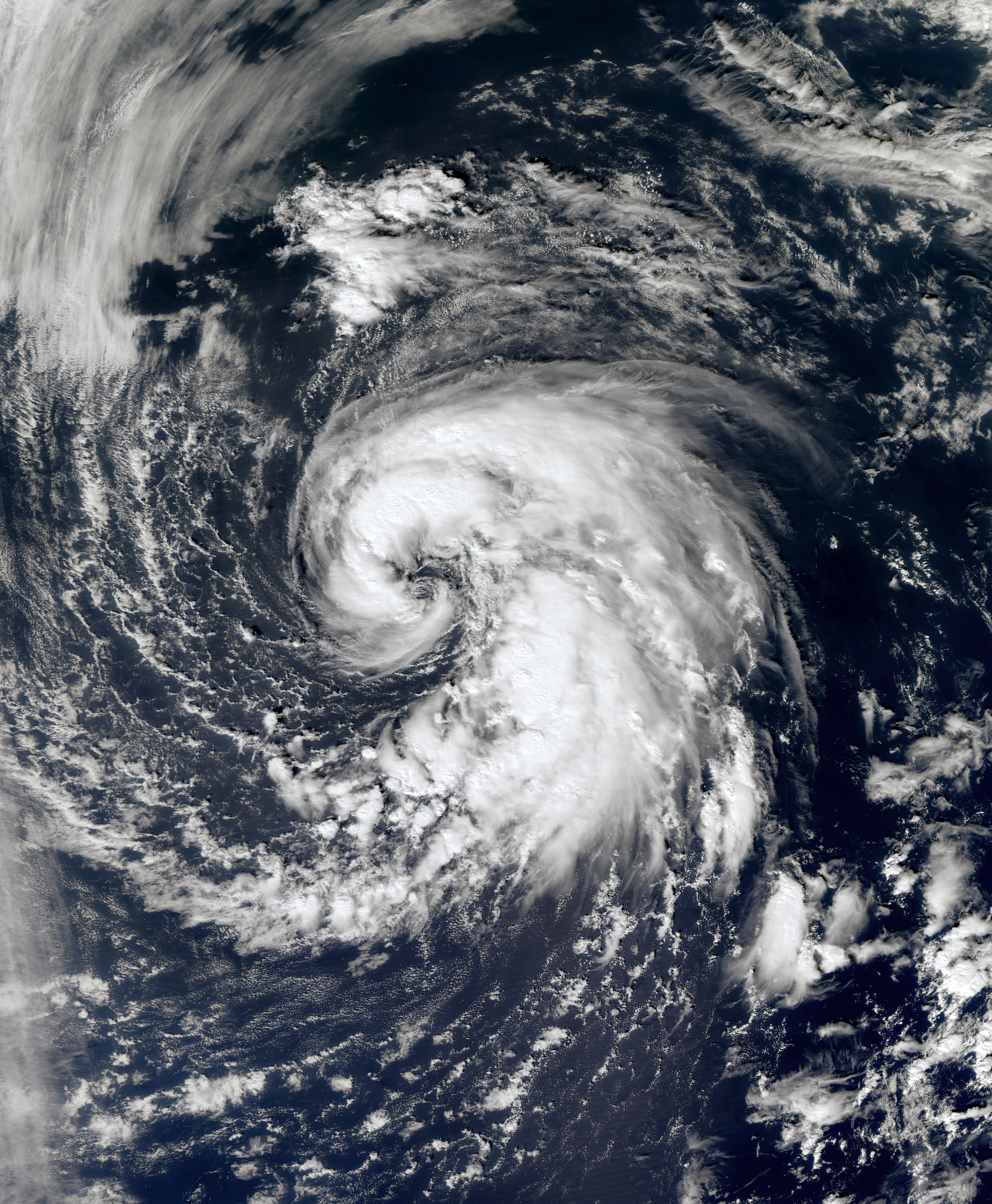
English: In late September, a large non-tropical system located over the north-central Atlantic slowly moved westward away from the Azores. The low produced hurricane-force winds, but did not exhibit the characteristics of a tropical cyclone. The storm steadily weakened over the following days, but developed tropical characteristics as it moved over slightly warmer waters.
By September 29, the low had developed sufficient convection and was declared Subtropical Storm Laura. Upon being upgraded, cold cloud tops began to wrap around the center of Laura and consolidate near the center of circulation. The convection organized around the center quickly and a satellite pass over the storm revealed that it could be intensifying. A later satellite pass disregarded the possibility of intensification as the intensity was confirmed to be at 60 mph (95 km/h). The overall structure of Laura remained subtropical but there were indications that it might have been acquiring tropical characteristics. As of 11 p.m. AST September 29 (0300 UTC September 30), Subtropical Storm Laura is located within 20 nautical miles of 38.3°N 48.4°W, about 585 mi (940 km) south-southeast of Cape Race, Newfoundland and Labrador. Maximum sustained winds are 50 knots (60 mph, 95 km/h), with stronger gusts. Minimum central pressure is 995 mbar (hPa; 29.38 InHg), and the system is moving north at 8 kt (9 mph, 15 km/h). |
| 날짜 | |
| 출처 | NASA Worldview |
| 저자 | NASA |
| 저작권 (이 파일을 인용하기) |
Public domain |
라이선스
| 이 파일은 NASA에서 제작하였으므로 퍼블릭 도메인입니다. NASA의 저작권 정책에 따르면 NASA의 자료는 명시하지 않는 이상 저작권의 보호를 받지 않습니다. (Template:PD-USGov, 또는 NASA 저작권 정책 문서, JPL 그림 사용 정책을 참고하세요.) | ||
 |
주의사항:
|
파일 역사
날짜/시간 링크를 클릭하면 해당 시간의 파일을 볼 수 있습니다.
| 날짜/시간 | 섬네일 | 크기 | 사용자 | 설명 | |
|---|---|---|---|---|---|
| 현재 | 2013년 4월 2일 (화) 20:31 | | 6,431 × 7,806 (34.11 MB) | Supportstorm | Geo-rectify |
| 2013년 3월 26일 (화) 14:51 |  | 7,329 × 7,915 (11.07 MB) | Earth100 | 250 meter res, better quality. |
이 파일을 사용하는 문서
다음 문서 1개가 이 파일을 사용하고 있습니다:
이 파일을 사용하고 있는 모든 위키의 문서 목록
다음 위키에서 이 파일을 사용하고 있습니다:
- de.wikipedia.org에서 이 파일을 사용하고 있는 문서 목록
- en.wikipedia.org에서 이 파일을 사용하고 있는 문서 목록
- es.wikipedia.org에서 이 파일을 사용하고 있는 문서 목록
- eu.wikipedia.org에서 이 파일을 사용하고 있는 문서 목록
- pt.wikipedia.org에서 이 파일을 사용하고 있는 문서 목록
- ru.wikipedia.org에서 이 파일을 사용하고 있는 문서 목록
- uk.wikipedia.org에서 이 파일을 사용하고 있는 문서 목록
- www.wikidata.org에서 이 파일을 사용하고 있는 문서 목록
- zh.wikipedia.org에서 이 파일을 사용하고 있는 문서 목록