파일:Aeolian Islands.jpg

미리 보기 크기: 396 × 599 픽셀 다른 해상도: 159 × 240 픽셀 | 317 × 480 픽셀 | 508 × 768 픽셀 | 677 × 1,024 픽셀 | 2,032 × 3,072 픽셀
원본 파일 (2,032 × 3,072 픽셀, 파일 크기: 610 KB, MIME 종류: image/jpeg)
파일 설명
| 설명 |
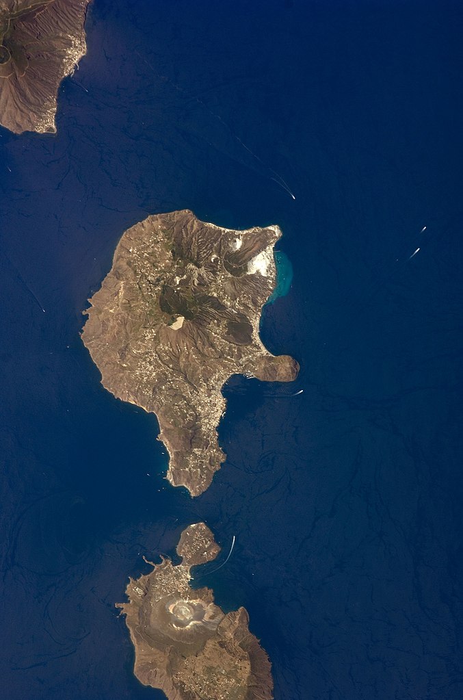
English: This detailed astronaut photograph features Lipari Island and the northern portion of Vulcano Island. Tan, speckled areas on both islands are urban areas and towns. Lipari is the largest of the Aeolian Islands, and it is a popular tourist destination due to its rugged volcanic topography and beaches (several boat wakes are visible around the islands). White pumice beaches and caves are located along the northern and northeastern coastlines of Lipari; black sand beaches derived from lava flows can also be found on the island. The most recent eruptive activity on Lipari took place from approximately AD 580–729.
|
||||||||||||||||||||||||||||||||||||||||||||||||||
| 날짜 | |||||||||||||||||||||||||||||||||||||||||||||||||||
| 출처 | NASA Earth Observatory | ||||||||||||||||||||||||||||||||||||||||||||||||||
| 저자 | This image was taken by the NASA Expedition 17 crew. | ||||||||||||||||||||||||||||||||||||||||||||||||||
| 카메라 위치 | | 이 지역의 다른 사진을 보기: OpenStreetMap |
|---|
This image or video was catalogued by Johnson Space Center of the United States National Aeronautics and Space Administration (NASA) under Photo ID: ISS017-E-9777. This tag does not indicate the copyright status of the attached work. A normal copyright tag is still required. See Commons:Licensing. Other languages:
|
This photograph was acquired with a Nikon D2Xs digital camera fitted with a 400 mm lens, and is provided by the ISS Crew Earth Observations experiment and the Image Science & Analysis Laboratory, Johnson Space Center.
라이선스
| 이 파일은 NASA에서 제작하였으므로 퍼블릭 도메인입니다. NASA의 저작권 정책에 따르면 NASA의 자료는 명시하지 않는 이상 저작권의 보호를 받지 않습니다. (Template:PD-USGov, 또는 NASA 저작권 정책 문서, JPL 그림 사용 정책을 참고하세요.) | ||
 |
주의사항:
|
파일 역사
날짜/시간 링크를 클릭하면 해당 시간의 파일을 볼 수 있습니다.
| 날짜/시간 | 섬네일 | 크기 | 사용자 | 설명 | |
|---|---|---|---|---|---|
| 현재 | 2013년 11월 15일 (금) 10:45 | | 2,032 × 3,072 (610 KB) | Rotatebot | Bot: Image rotated by 90° |
| 2011년 5월 5일 (목) 02:07 |  | 3,072 × 2,039 (555 KB) | Originalwana | higher res | |
| 2009년 5월 24일 (일) 01:23 |  | 939 × 586 (115 KB) | Originalwana | {{Information |Description={{en|1=This detailed astronaut photograph features Lipari Island and the northern portion of Vulcano Island. Tan, speckled areas on both islands are urban areas and towns. Lipari is the largest of the Aeolian Islands, and it is |
이 파일을 사용하는 문서
다음 문서 1개가 이 파일을 사용하고 있습니다:
이 파일을 사용하고 있는 모든 위키의 문서 목록
다음 위키에서 이 파일을 사용하고 있습니다:
- ar.wikipedia.org에서 이 파일을 사용하고 있는 문서 목록
- ast.wikipedia.org에서 이 파일을 사용하고 있는 문서 목록
- ca.wikipedia.org에서 이 파일을 사용하고 있는 문서 목록
- ceb.wikipedia.org에서 이 파일을 사용하고 있는 문서 목록
- cy.wikipedia.org에서 이 파일을 사용하고 있는 문서 목록
- de.wikivoyage.org에서 이 파일을 사용하고 있는 문서 목록
- el.wikipedia.org에서 이 파일을 사용하고 있는 문서 목록
- en.wikipedia.org에서 이 파일을 사용하고 있는 문서 목록
- en.wikivoyage.org에서 이 파일을 사용하고 있는 문서 목록
- es.wikipedia.org에서 이 파일을 사용하고 있는 문서 목록
- eu.wikipedia.org에서 이 파일을 사용하고 있는 문서 목록
- fr.wikivoyage.org에서 이 파일을 사용하고 있는 문서 목록
- gl.wikipedia.org에서 이 파일을 사용하고 있는 문서 목록
- he.wikivoyage.org에서 이 파일을 사용하고 있는 문서 목록
- hr.wikipedia.org에서 이 파일을 사용하고 있는 문서 목록
- id.wikipedia.org에서 이 파일을 사용하고 있는 문서 목록
- it.wikipedia.org에서 이 파일을 사용하고 있는 문서 목록
- it.wikivoyage.org에서 이 파일을 사용하고 있는 문서 목록
- lb.wikipedia.org에서 이 파일을 사용하고 있는 문서 목록
- nl.wikipedia.org에서 이 파일을 사용하고 있는 문서 목록
- ro.wikipedia.org에서 이 파일을 사용하고 있는 문서 목록
- sl.wikipedia.org에서 이 파일을 사용하고 있는 문서 목록
- www.wikidata.org에서 이 파일을 사용하고 있는 문서 목록
- zh-yue.wikipedia.org에서 이 파일을 사용하고 있는 문서 목록
- zh.wikipedia.org에서 이 파일을 사용하고 있는 문서 목록