파일:Cadarache (red dot) CIA World Factbook map.png
최대 해상도입니다.
Cadarache_(red_dot)_CIA_World_Factbook_map.png (327 × 350 픽셀, 파일 크기: 15 KB, MIME 종류: image/png)
_CIA_World_Factbook_map.png?uselang=ko)
파일 설명
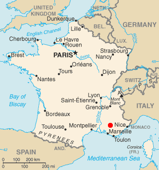
After seeing http://upload.wikimedia.org/wikipedia/en/5/56/1cadarache-arrow.JPG[dead link], my eyes hurt from its highly unprofessional look. I was sure I could do better in 10 seconds, so here is a map showing (roughly) the location of the Cadarache research center. The map is based on the CIA World Factbook article on France updated in November 2005, with a red dot placed as accurately as I could on the location of Cadarache, based on the ugly image mentioned above and external maps.
라이선스
이 파일은 미국 법전 제17편 제1장 제105조에 따른 미국 연방정부의 공무원 또는 피고용인이 공무상 작성한 저작물로, 미국에서 퍼블릭 도메인입니다.
주의: 본 라이선스는 미국 연방정부의 저작물에 관해서만 효력이 있습니다. 미국의 주, 군, 기타 지방자치단체가 만든 저작물에 대해서는 적용되지 않습니다. 또한 미국 우정청이 1978년부터 발행한 우표 디자인에도 적용되지 않습니다.
|
 | |
| 이 저작물은 모든 저작인접권을 포함한 저작권법하의 규제로부터 자유로운 것으로 확인되었습니다. | ||
파일 역사
날짜/시간 링크를 클릭하면 해당 시간의 파일을 볼 수 있습니다.
| 날짜/시간 | 섬네일 | 크기 | 사용자 | 설명 | |
|---|---|---|---|---|---|
| 현재 | 2012년 1월 7일 (토) 04:24 | | 327 × 350 (15 KB) | Quibik | Removed the thin border. |
| 2005년 12월 25일 (일) 06:47 |  | 328 × 353 (15 KB) | Gspr~commonswiki | After seeing [http://upload.wikimedia.org/wikipedia/en/5/56/1cadarache-arrow.JPG], my eyes hurt from its highly unprofessional look. I was sure I could do better in 10 seconds, so here is a map showing (roughly) the location of the Cadarache research |
이 파일을 사용하는 문서
다음 문서 1개가 이 파일을 사용하고 있습니다:
이 파일을 사용하고 있는 모든 위키의 문서 목록
다음 위키에서 이 파일을 사용하고 있습니다:
- bs.wikipedia.org에서 이 파일을 사용하고 있는 문서 목록
- en.wikipedia.org에서 이 파일을 사용하고 있는 문서 목록
- eo.wikipedia.org에서 이 파일을 사용하고 있는 문서 목록
- es.wikipedia.org에서 이 파일을 사용하고 있는 문서 목록
- fi.wikipedia.org에서 이 파일을 사용하고 있는 문서 목록
- fr.wikipedia.org에서 이 파일을 사용하고 있는 문서 목록
- hi.wikipedia.org에서 이 파일을 사용하고 있는 문서 목록
- hu.wikipedia.org에서 이 파일을 사용하고 있는 문서 목록
- it.wikipedia.org에서 이 파일을 사용하고 있는 문서 목록
- ja.wikipedia.org에서 이 파일을 사용하고 있는 문서 목록
- lt.wikipedia.org에서 이 파일을 사용하고 있는 문서 목록
- nl.wikipedia.org에서 이 파일을 사용하고 있는 문서 목록
- pl.wikipedia.org에서 이 파일을 사용하고 있는 문서 목록
- pl.wikinews.org에서 이 파일을 사용하고 있는 문서 목록
- ru.wikipedia.org에서 이 파일을 사용하고 있는 문서 목록
- sv.wikipedia.org에서 이 파일을 사용하고 있는 문서 목록
- tr.wikipedia.org에서 이 파일을 사용하고 있는 문서 목록
- tt.wikipedia.org에서 이 파일을 사용하고 있는 문서 목록
- uk.wikipedia.org에서 이 파일을 사용하고 있는 문서 목록
- uz.wikipedia.org에서 이 파일을 사용하고 있는 문서 목록
- zh.wikipedia.org에서 이 파일을 사용하고 있는 문서 목록
_CIA_World_Factbook_map.png)